Get Forecast For:
Lawrenceville Weather

Hurricane Activity to Increase After Gustav

Monday, September 1st, 2008

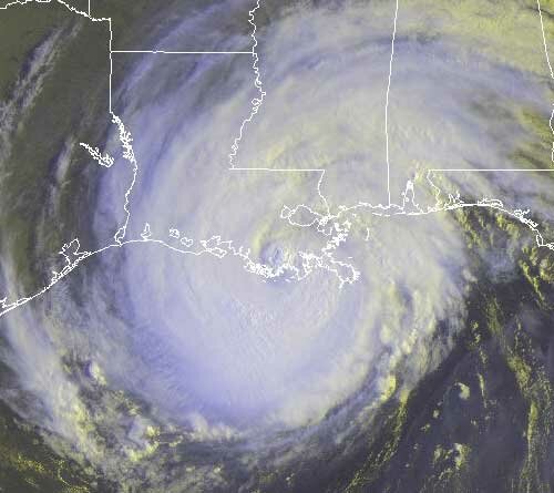
Hurricane Gustav made landfall about 10 AM in Cocodrie, Louisiana, about 70 miles southwest of New Orleans. At this point, it looks like New Orleans will not face a repeat of the disaster brought about by Hurricane Katrina, although I suspect that we’ll know more in the morning. Here’s a satellite picture of Gustav taken about 9:45, just before landfall:
Gustav is expected to linger in the Arkansas/Texas/Oklahoma area for a few days dropping plenty of rain, possibly up to 20 inches in some areas. At some point, it’s going to get picked up by a low pressure system and taken northwest into Ohio. This means that except for the few showers Georgia is seeing today from extended hurricane bands, we aren’t likely to have any effects from Gustav.

Don’t worry though, because there is more where that came from. Hanna was upgraded to a hurricane this morning, about a day faster than what was previously forecast by the Tropical Prediction Center. The latest estimate is that Hanna will not change position much through Tuesday before becoming a category 2 hurricane early Thursday and beginning a northward trek that could lead to landfall in Georgia. The current estimate puts landfall near Savannah sometime on Friday, followed by a rapid move north into the Mid-Atlantic.

There is still some uncertainty over exactly where Hanna will make landfall and the exact strength of the storm when it does, but no matter whether it’s Brunswick, Savannah or Charleston, I wonder if the networks will pay as much attention to Hanna as they are to Gustav. In any case, as I heard Joe Bastardi say on the radio this afternoon, Atlanta and Macon are likely to get only a “glancing blow” from Hanna. Bastardi pointed to Hurricane Floyd back in 1999 as his guess of a comparable storm.

If Gustav and Hanna aren’t going to be drought-busters in Georgia, maybe the third time will be the charm. The Hurricane Center today identified Tropical Depression Eight, which by afternoon became Tropical Storm Ike. Ike has been brewing as a low pressure system off the coast of Africa for the past few days, and will move across the Atlantic fairly rapidly, probably turning into a hurricane by Wednesday. By Saturday, it will be in roughly the same location that Hanna is today.

While it’s too early to tell exactly what will happen to Ike once he approaches the Bahamas. It could follow Hanna north along the east coast, or move into the Gulf coast either through or south of Florida. The European model has Ike moving into the eastern Gulf and then recurving north through Alabama and Georgia sometime after September 10th.

And don’t look now, but there’s another strong tropical wave southeast of the Cape Verde Islands that the hurricane center says could develop into yet another tropical depression or storm in the next day or two. If it does, it will be named Josephine.

Sphere: Related Content

Share

1.9 Million Evacuate Coastal Louisiana in Preparation for Gustav

Sunday, August 31st, 2008

Not wanting to get caught like they did 3 years ago with Katrina, an estimated 90-95% of coastal Louisianans have left for locations north and west to get out of the way of Gustav, including an estimated 200,000 from New Orleans. Overall, things seem to be much better prepared than they were three years ago, although I wonder where Mayor Ray Nagin got this idea (via the New York Times):

The storm, he said, was now 900 miles wide, compared with 400 miles for Katrina. Even the capital of Baton Rouge, 80 miles inland from New Orleans, could experience hurricane force winds of up to 100 m.p.h., he said. But Dennis Feltgen, a spokesman for the National Hurricane Center, said he had no idea what the mayor meant by a 900-mile footprint, saying that hurricane force winds do not extend nearly that far.

New Orleans goes quiet before the storm

In any case, at 5 PM, Gustav was a category 3 hurricane, with winds of 115 MPH, located 215 miles southeast of the Mississippi River. Satellite images show banding reaching up into South Georgia. The latest pressure reading was 957 millibars. The storm has not strengthened as much as was expected previously, which is good, with the storm expected to make landfall west of New Orleans sometime early Monday afternoon.

Comparing Gustav with Katrina, shortly before landfall, Katrina had winds of 166 MPH, with a minimum pressure of 902 MB: a much stronger storm. However, the Weather Service has issued a strong warning:

IN THE AREA NEAR LANDFALL OF THE EYE…EXTREMELY DANGEROUS WINDS WILL CAUSE EXTENSIVE DAMAGE…AND ALL MOBILE HOMES WILL BE DESTROYED. HOUSES OF POOR TO AVERAGE CONSTRUCTION MAY BE SEVERELY DAMAGED OR DESTROYED. MODERATE TO MAJOR DAMAGE COULD OCCUR TO WELL CONSTRUCTED HOMES. MANY GABLED ROOFS MAY FAIL ALONG WITH SOME EXTERIOR WALLS. ALUMINUM AND LIGHT STEEL ROOFS WILL BE TORN OFF BUILDINGS AT INDUSTRIAL PARKS. PARTIAL ROOF AND EXTERIOR WALL FAILURES ARE LIKELY AT LOW RISE APARTMENT BUILDINGS…ESPECIALLY THOSE OF POOR TO AVERAGE CONSTRUCTION. SOME WINDOWS IN HIGH RISE OFFICE BUILDINGS WILL BE BLOWN OUT. AIRBORNE DEBRIS HAS THE POTENTIAL TO CAUSE ADDITIONAL MAJOR DAMAGE…AS WELL AS INJURIES AND A FEW FATALITIES. NEAR TOTAL POWER LOSS IS EXPECTED WITH NUMEROUS LINES AND POWER POLES KNOCKED DOWN. THE AVAILABILITY OF POTABLE WATER WILL BE DIMINISHED AS FILTRATION SYSTEMS BEGIN TO FAIL. NUMEROUS TREES…ESPECIALLY SMALL TO MEDIUM TREES…WILL BE DOWNED…SNAPPED OR UPROOTED.

MANY RESIDENCES OF AVERAGE CONSTRUCTION IMPACTED BY THE STORM SURGE MAY BE HEAVILY DAMAGED OR DESTROYED. NUMEROUS ROADS WILL BE SWAMPED. ENTIRE FLOOD PRONE COASTAL COMMUNITIES WILL BE CUTOFF BY STORM SURGE FLOODING. SIGNIFICANT STORM SURGE FLOODING WILL MOVE WELL INLAND ESPECIALLY ALONG BAYS AND BAYOUS. A STORM SURGE OF THIS MAGNITUDE COULD RESULT IN EXTENSIVE FLOODING AND POSE A THREAT TO LIFE AND PROPERTY.

The threat of the storm caused the Republican National Committee to hold activities at their St. Paul convention to a minimum on Monday. About all we can do now is wait and hope for the best. If you want to get a sense of what’s going on from the New Orleans perspective, visit the New Orleans Times Picayune website. You can also stream New Orleans’ TV stations here.

The next question is what is going to happen to Gustav after landfall. Some models indicate that the storm will linger in the Louisiana/Texas area and eventually peter out, while others show the remnants of Gustav being picked up by a low pressure system, and dragged east, which could affect North Georgia and Atlanta’s weather by next weekend.

Also, Tropical Storm Hanna has been chugging along slowly in the Atlantic. The latest projected track has Hanna making landfall somewhere near Savannah, Georgia as a Category 1 hurricane on Friday. Some models show landfall further north in North or South Carolina, while others pull the storm southwest towards Florida. Landfall to the north would minimize the storm’s effect on the Atlanta area, while a more southerly track could bring Hanna’s presence known here.

What happens with both Gustav and Hanna will be determined by three upper level features: a strong ridge of high pressure that will move from the Midwest to the Mid-Atlantic in the next day or so, a closed low pressure system that will develop off the New England coast and the aforementioned low pressure trough in the Northwest. Until we know the exact effects of these systems, North Georgia will actually be in for some good weather, with lower humidity for midweek, courtesy of the ridge.

Sphere: Related Content

Share

Gustav Set to Hit Monday – Hanna May Be a Bigger Georgia Threat

Saturday, August 30th, 2008

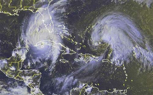
The twin threats of Hurricane Gustav and Tropical Storm Hanna almost guarantee that tropical weather will be in the news for the next week to ten days. Gustav is just about to make landfall as a powerful category 4 hurricane over western Cuba, while Hanna is becoming slightly more organized as a tropical storm about 250 miles east of the Bahamas.

Gustav is expected to strengthen into a category 5 hurricane after it passes over Cuba, and all models have it making landfall somewhere on the Louisiana coast sometime Monday afternoon. The intensity is expected to drop to category 4 by the time he makes landfall, and the storm is likely to move northwest through Louisiana and Texas in the two or three days after landfall. After the devastation caused by Katrina three years ago, officials are taking no chances, but if the storm follows the NHC path, while New Orleans will get a lot of rain, there is less risk to the levees if the storm follows its current projected path. Evacuation efforts have begun, and FEMA is assembling materials needed should disaster strike.

(more…)

Sphere: Related Content

Share

What a Difference a Storm Makes

Thursday, August 28th, 2008

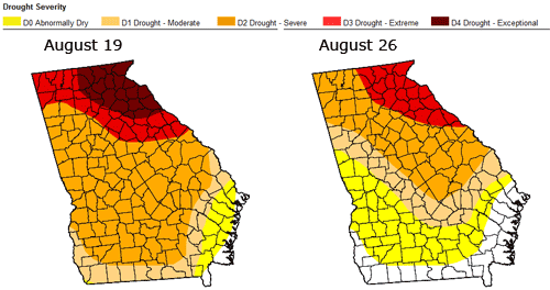
The two maps below show the tremendous difference a tropical system can make in dampening the effects of a drought. The map at left shows drought conditions in Georgia as of Tuesday, August 19th, when almost ten percent of the state was in exceptional drought conditions and only two percent was drought free. The right hand map shows conditions as of Tuesday morning the 26th at 7 AM. Now, none of the state is in exceptional drought, and 16% is drought free.

Remember, the cutoff for the drought maps was 7 AM Tuesday, which was before a good bit of the rain hit North Georgia, so I expect to see continued improvement with next week’s drought monitor as well. Lake Lanier has also risen just over two feet from the rainfall brought on by Fay.

The weather service has investigated the severe weather brought about by Fay, and has issued a report saying that there were six tornadoes in Georgia brought on by the storm. Most of the damage was in Hall and Jackson counties. Three EF1 tornadoes with 90 MPH winds were verified in Hall, where trees were knocked down and damage was reported to an elementary school.

Another tornado with 100 MPH winds touched down near Commerce in Jackson County, while two additional EF0 tornadoes with 70 MPH winds were reported in Monroe and Wilkes counties.

(more…)

Sphere: Related Content

Share

Fay Brings Welcome Rainfall, With Maybe More to Come

Tuesday, August 26th, 2008

It looks like the worst of Fay has finally left north Georgia, although some counties to the east of Atlanta are having tornado warnings, the tornado watch was just extended until 2 AM Wednesday for much of northeast Georgia and South Carolina, and a flash flood watch remains in effect until 8 PM. We may get a few more showers overnight, but there are bits of blue skies showing. Fay is becoming extratropical, and will move northeast to bother the mid Atlantic states for the next day or so.

Let’s take a look at some of what Fay has done. First of all, Lake Lanier has risen about six inches as of noontime today from where it was early Monday morning. Much of the Lake Lanier watershed received some good rainfall over the past day or two, including Gainesville, with 2.64 inches so far today and .73 inches yesterday and Helen with 4.01 inches over the past two days. I expect Lanier to continue to rise over the next few days as much of the runoff from the storm continues to flow into the lake.

With 2.07 inches of rain today and .99 inches on Monday evening and Tuesday, I’ve recorded 48 hour precipitation of 3.06 inches at my weather station. Today’s rain here is the most in one calendar day since November 15, 2006, when 2.19 inches of rain fell, and as best as I can tell is the most 2 day precipitation since Tropical Storm Cindy came through on July 6-7, 2005, leaving 4.62 inches of rainfall.

My station, which is obviously not official, is on the low end of the rainfall scale. Some other two day rainfall totals include Alpharetta with 5.39 inches, Atlanta Hartsfield with 3.09 inches, Cleveland with 5.14 inches, Cumming with 4.52 inches and Cedartown, with 2.87 inches. It looks like Thomasville, Georgia is going to have the most rainfall from Fay–even beating anywhere in Florida–with a whopping 27.5 inches total precipitation through 2 PM today.

(more…)

Sphere: Related Content

Share