Tropical Weather Finally Shows Up
Tuesday, August 11th, 2009It has been one of the quietest starts to the hurricane season in years. While most years have at least one named Atlantic storm in July, there have been none yet this year. The last time it took this long to get a named storm was 1992, when Hurricane Andrew hit Florida. The lack of storms is being blamed on El Nino conditions this year, which tend to produce conditions in the Atlantic that don’t favor tropical development.
We still don’t have a named storm, but are likely to get one by this time tomorrow. The National Hurricane Center has identified Tropical Depression Two forming from a wave off the African coast. The depression, which will become tropical storm Ana if it intensifies, is too far east to know where or if it will impact the US coastline.
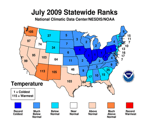
As a followup to my earlier post on July temperatures, the NCDC released its official temperature rankings for July, and it looks like a lot of records were broken.

It was the coldest July in 115 years of recordkeeping on Iowa, Illinois, Indiana, Ohio, Pennsylvania and West Virginia, with Wisconsin, Missouri, Michigan and Kentucky having their second coldest July ever. In Georgia, it was the 15 coolest July on record.
The 90 degree temperatures we’ve seen for the last week or so have kept August about 1.5 degrees above normal so far. Today will likely be the last day we see 90 for the rest of the week, as an approaching frontal system and the attendant clouds and storms will keep temperatures down. Today is the last of the Dog Days, traditionally the hottest period of the summer, from July 3rd through August 11th. And today’s ‘normal’ low dropped by a degree from yesterday, from 71 to 70. By the end of the month, the daily average temperature will have dropped by three degrees from today’s 80.
Sphere: Related Content
