Get Forecast For:
Lawrenceville Weather

First Frost of the Fall This Week?
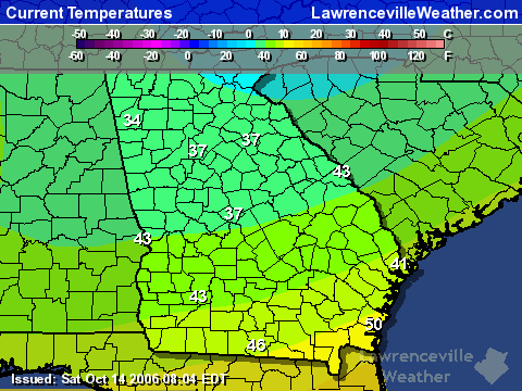
Monday, October 27th, 2008

The chilly wind you feel today is courtesy of a cold front bringing Canadian air into North Georgia. The front stretched from New York to Louisiana early this morning, crossing the Atlanta area, and by this evening will be into mid-Florida. Tonight, we’ll have the coldest temperatures of the year so far, with an expected low around 34. Possible freezing conditions extend as far south as Florida:

Tuesday night could be even colder, with dry air and clear skies radiating whatever warmth we get during the day. The possible good news is that unless if it doesn’t get down to freezing, we may not get much frost tonight due to the winds. By tomorrow night, the winds should start to diminish, making frost more likely.

Unless temperatures get much colder than expected, it probably won’t be a record. The record low for October 28th at Hartsfield airport is 31 degrees, set back in 1957, while the record for the 29th is 28 degrees in 1976.

So if you’re like me, and still have houseplants outdoors, today might be a good day to bring the plants inside. For that matter, if you still have summer annuals outside, pull them up–it’s a lot easier to do before the cold weather gets to them.

Sphere: Related Content

Share

Tropical Storm Noel Forms South of Cuba

Sunday, October 28th, 2007

The low pressure system south of Haiti was upgraded to a tropical depression last evening, and this afternoon, was upgraded to a tropical storm.  Noel (pronounced Nole, by the way, not like the Christmas synonym) is presently 125 miles south of Haiti, and is headed towards Cuba.

Forecasters expect Noel to move northwest, and cross Cuba sometime Tuesday morning.  While the official forecast calls for winds to remain in the tropical storm range for the next few days, it’s not out of the question that it could intensify into a hurricane, either before or after crossing Cuba.

The ultimate path is still uncertain, and it’s possible that the storm could bring some rainfall to Georgia. It’s worth keeping an eye on.

Another thing worth keeping an eye on is the nighttime low temperatures over the next few days.  The Weather Service has issued a special weather statement advising of the possibility of frost tonight in the Georgia mountains tonight, and a better possibility of frost all the way south to a La Grange – Thomaston  – Warrenton line on Monday night.

The cold blast is bringing a freeze to Southern Ohio, West Virginia, and parts of Virginia tonight, and slightly further south Monday night.  If the cold weather doesn’t get here Monday night, there’s a chance coming again next week, so it’s probably a good time to get the house plants inside.

Sphere: Related Content

Share

Masters Outlook: Frost Delays?

Friday, March 30th, 2007

The world’s golf community will arrive in Georgia next week for the Masters in Augusta. Taking an early look at the weather forecast for the event, it looks like those that make the cut will need to wear warm clothes as they drive down Magnolia Lane.

No matter which way you look at it, it looks like Georgia (and much of the East) is due for a cold spell from next weekend through the middle of April. The Climate Predication Center’s 6-10 day outlook for the 5th through 9th calls for colder than normal temperatures for the eastern part of the country, particularly the northeast. The period of the 7th through the 13th continues the trend, although with a little less confidence.

Accuweather is predicting low temperatures just above freezing next Saturday and Sunday mornings, which could mean a frost delay for the early morning rounds. Weather.com is more conservative, calling for lows in the low 40s. We will see what the Weather Service has to say on Sunday. Similar low temperatures are being forecast for the Atlanta area.

Had the PGA been following its old schedule, we would have the AT&T Classic in Duluth going on right now. While today’s surprise shower probably wouldn’t have been a big issue, the 1-2 inches of rain we could get on Sunday would have been a big problem. The good news about that amount of rain in the forecast is that it will definitely wash the pollen away, in addition to bringing much-needed rain to north Georgia.

So, if you’re thinking about planting your annuals this weekend, you might want to think twice. The weather of the last week or so may make it feel like summer is here, but we’re only at the first of April, and you don’t want to look like a fool should your new plants freeze on Easter weekend.

Sphere: Related Content

Share

Cold Weather In Store for Atlanta, Much of the Nation This Week

Sunday, December 3rd, 2006

While Georgia managed to avoid the effects of last week’s storm, which left snow in a wide swath from Texas to Michigan, and left hundreds of thousands of people without power, it looks like this week’s cold wave will bring the coldest temperatures yet this season to the area.

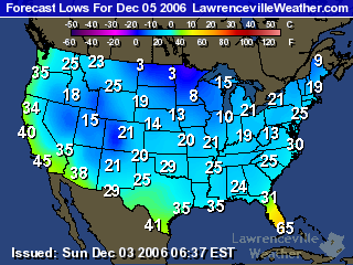
The map to the right shows the predicted lows for the US on Tuesday morning. Here in the Atlanta area, we’ll likely see temperatures below 25 degrees Tuesday morning, and maybe just slightly warmer on Wednesday. Monday isn’t likely to be any picnic either, with highs in the mid 40s, and blustery winds to make it feel even colder.

The good news is that these may be the lowest temperatures we see for the rest of the year. We’re somewhat due for a real killing frost: in my yard, the wood ferns are still growing, the ornamental peppers are still producing fruit, and a few volunteer impatiens are still blooming. They should all be history by Tuesday afternoon. Last year, we saw temperatures in the mid 20s before Thanksgiving.

There’s also some concern that we could see some wintry weather by the end of the week as a low pressure system in the Gulf brings moisture into the area as a high pressure system pushes colder air in from the Northwest. This morning’s forecast for Gainesville calls for a chance of freezing rain on Saturday morning, although it’s not predicted –yet– for metro Atlanta. It’s a situation that bears watching.

Sphere: Related Content

Share

Record Cold for North Georgia

Saturday, October 14th, 2006

This morning’s low temperature of 37 degrees recorded here in Lawrenceville is close to a record. The record low for Atlanta for October 14th is 38 degrees, set back in 1979. Other area lows this morning include 34 degrees in Duluth at the Atlanta Athletic Club and in Alpharetta at the Golf Club of Georgia, and 42 degrees at Atlanta Hartsfield Airport. The map below shows the below 40 degree weather extended as far south as Macon.

Early reports also show temperatures dropped to freezing this morning in Dalton, Rome, and Peachtree City. Overall, temperatures this morning are between 15 and 20 degrees below the normal low of 55.

While this morning’s cold may have been a record for the day in some locations, it’s not the earliest frost. That would be on October 11th for Atlanta, or October 9th for Athens. Normally, the first frost in metro Atlanta is around November 10th. In 2005, the first frost was on November 17th, while in 2004, we stayed frost free until December 14th.

This morning may have been the coldest of the current cool weather, caused by a Canadian high pressure system that brought record lake-effect snow to the Buffalo, New York area, (2 feet, including 8.6 inches on Thursday — an October record) and snows across the Great Lakes area.

This high pressure system will move out of the area by Sunday evening, making way for something we haven’t seen much of this month, rain. Later in the week, temperatures could rise back into the mid 80s by Wednesday, and more seasonable temperatures through the end of the month.

Sphere: Related Content

Share