Get Forecast For:
Lawrenceville Weather

Labor Day Weekend: Donate to Katrina Relief
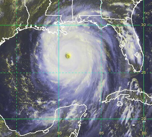
Thursday, September 1st, 2005

Over the last few days, it has become obvious that the destruction caused by Katrina to New Orleans, Mississippi, and the Gulf Coast has gone from bad to worse. The Internet Community is responding by declaring September 1st through 5th as Hurricane Katrina Blog for Relief Weekend.

The idea is that each blogger will recommend a charity for donations to Katrina relief. In my case, I’m recommending the Atlanta Red Cross. If you would like to make a donation, click here. I have made a generous donation, and I encourage you to donate what you can.

If you prefer, you can select another charity for your contribution; Instapundit maintains a comprehensive list.

Hurricane Katrina is going to rank as one of the worst natural disasters ever to hit the United States. You just don’t think of Americans being called refugees. The Atlanta area is already becoming a major destination for people fleeing the wrath of Katrina. Several hundred sick and injured people from New Orleans hospitals were flown into Dobbins Air Force Base today, and will be taken care of by Atlanta area hospitals. Colleges and universities in Georgia have announced they will accept students that were planning to attend school in the storm affected area.

People in Gwinnett will certainly make their contribution to the Katrina relief effort. You can help by making a contribution to the Atlanta Red Cross.

Technorati categories: flood aid and hurricane katrina

If you make a contribution, make sure you log it here.

Sphere: Related Content

Share

Observations on Katrina

Wednesday, August 31st, 2005

By now, I think that most people have had a chance to understand the devastation that Hurricane Katrina caused in Louisiana and the Gulf Coast. After watching the news tonight, I am amazed not only at the destruction in Mississippi and Alabama that the storm caused, but at the fact that the predictions made by the weather service for New Orleans seem to have come true.

While the country will have to deal with the effects of Katrina (and everyone is encouraged to contribute to the Katrina Relief effort), there are a few weather-related observations that need to be made:

  • The effects of a hurricane can be measured not only by wind speed, but by the barometric pressure at the eye of the storm. When the storm hit New Orleans, the barometric pressure was 915 millibars, or 27.02 inches of mercury. It had been as low as 902 millibars, or 26.64 inches of mercury. With pressure as low as this (“normal pressure” is about 30 inches), it’s no wonder that the storm had such a damaging effect.
  • The intensity of the hurricanes this season in general, and Hurricane Katrina in particular, was not caused by global warning, and there wasn’t anything anyone could ‘do’ to prevent it. Hurricanes are Nature’s way of equalizing the temperature differences between the heat of the tropics and the cold of the Arctic. Essentially hurricanes move the heat of the oceans up into the upper atmosphere. As David Chandley explained in a talk at the NFL Luncheon today, were it not for hurricanes, the tropics would be even warmer, and the polar regions would be solid ice.

If there’s any good news to be had on the weather front, it’s that the weather in Atlanta for Labor Day weekend is expected to be wonderful. The heat and humidity of summer is losing its grip. By the weekend, we could be seeing temperatures in the low to mid 80s during the day, and lows in the low to mid 60s, with low humidity.

On the tropical storm front, Tropical Depression 13 has become Tropical Storm Lee as of 5 PM today.

It continues its slow moving path, and is not expected to affect the United States.

Sphere: Related Content

Share

Katrina Reduced to Tropical Storm; Cooler Weather Ahead

Monday, August 29th, 2005

Hurricane Katrina made landfall this morning in southern Louisiana, and fortunately did not make a direct hit on New Orleans. It appears that the worst of the storm’s effects will be in Mississippi, although as of now, fatalities appear to be minimal. The storm will still be marked as a memorable one, with even the Atlanta Journal-Constitution issuing an Extra edition for newsstands this morning with late breaking news from Louisiana.

As of early this evening, Katrina had been reduced to a tropical storm, although it will continue to bring rain and the possibility of tornados as it moves northward through Tennessee, Kentucky, and the northeast through the end of the week.

In Georgia, numerous tornado warnings were issued in the metro Atlanta area from about 5:00 PM through mid evening. As could be expected with the center of the storm so far to the west, it appears that the worst of the damage was in Carroll County, close to the Alabama state line. Additional rain bands from the storm will continue to affect our area through mid afternoon on Tuesday. Models predict that Katrina will continue heading north through Mississippi before taking a more easterly path once it reaches the Tennessee border, meaning that we are likely to see, at most, a few inches of rain.

With the end of August at hand, it’s time for some cooler weather, and it looks like that may happen shortly after Labor Day. Long range models predict cooler than normal temperatures (and lower than normal rainfall) for Labor Day week, with a distinct possibility of nighttime temperatures dropping below 60 degrees on several evenings.

As far as tropical weather goes, TD 13 appears to have petered out, and is unlikely to affect US weather at all.

Sphere: Related Content

Share

How Bad is Hurricane Katrina Likely To Be?

Sunday, August 28th, 2005

I copied this advisory from the National Weather Service. It was issued at 5:13 PM EST on Sunday afternoon. The only thing I changed was all uppercase to mixed case to make it easier to read.

URGENT – WEATHER MESSAGE NATIONAL WEATHER SERVICE NEW ORLEANS LA 413 PM CDT SUN AUG 28 2005

…Extremely Dangerous Hurricane Katrina Continues to Approach the Mississippi River Delta… …Devastating damage expected…

Most of the area will be uninhabitable for weeks…perhaps longer. At least one half of well constructed homes will have roof and wall failure. All gabled roofs will fail…leaving those homes severely damaged or destroyed.

The majority of industrial buildings will become non functional. Partial to complete wall and roof failure is expected. All wood framed low rising apartment buildings will be destroyed. Concrete block low rise apartments will sustain major damage…including some wall and roof failure.

High rise office and apartment buildings will sway dangerously…a few to the point of total collapse. All windows will blow out.

Airborne debris will be widespread…and may include heavy items such as household appliances and even light vehicles. Sport utility vehicles and light trucks will be moved. The blown debris will create additional destruction. Persons…pets…and livestock exposed to the winds will face certain death if struck.

Power outages will last for weeks…as most power poles will be down and transformers destroyed. Water shortages will make human suffering incredible by modern standards.

The vast majority of native trees will be snapped or uprooted. Only the heartiest will remain standing…but be totally defoliated. Few crops will remain. Livestock left exposed to the winds will be killed.

An inland hurricane wind watch is issued when sustained winds near hurricane force…or frequent gusts at or above hurricane force…are possible within the next 24 to 36 hours.

I was in New Orleans in late June. It’s a wonderful city. I hope there is something left by this time tomorrow.

Sphere: Related Content

Share

Katrina: Mixing the Worst of Camille and Betsy

Sunday, August 28th, 2005

Hurricane Betsy hit Louisiana in September, 1965, as a category 3 storm, with winds of 135 MPH, following a track similar to what we are seeing with Katrina. She caused 8.5 billion dollars of damage, in 2000 dollars. Four years later, on August 16th, 1969, Camille struck as a category 5 storm, with winds of 200 MPH. Forecasters believe that Katrina may rank along with these two powerful hurricanes in terms of effects and damage.

New Orleans is hunkering down. The city is being evacuated, and about 100,000 people are taking refuge in the Superdome. Katrina is presently located 150 miles south of the mouth of the Mississippi River. It’s a category 5 storm, with winds up to 165 MPH. If it remains a Category Five storm, it will be one four category 5 storms ever to make landfall in the United States. With expected storm surges of up to 25 feet, the city could be underwater by this time on Monday.

The image above was taken around 4 PM this afternoon, and shows the eye of the storm, and the bands of rain affecting Louisiana and Mississippi. This powerful storm has hurricane force winds extending out 100 miles in each direction from the center. The very first rain bands are beginning to affect central and north Georgia this afternoon.


The image to the right is the National Weather Service estimate of precipitation from 8 PM Sunday through 8 PM Tuesday. Atlanta could receive 3 to 4 inches of rain, along with the possibility of tornadoes.

Meanwhile, Tropical Depression 13 is now a reality. It is expected to become Tropical Storm Lee by sometime Tuesday afternoon. The projected path takes the storm northeast of the Dominican Republic by Friday afternoon, and could be affecting the east coast of the US by the day after Labor Day.

Sphere: Related Content

Share