Get Forecast For:
Lawrenceville Weather

The Weather May Put a ‘Wedge’ in Election Day Voting

Friday, October 31st, 2008

The effect of the weather on voter turnout is an oft debated question.  Certainly, it makes sense that more people will be likely to vote on a sunny, warm day than one that is cold and raining.  Unfortunately, at least here in Georgia, it looks like the weather won’t be ideal for voting, and other parts of the country could see rain and snow as well:
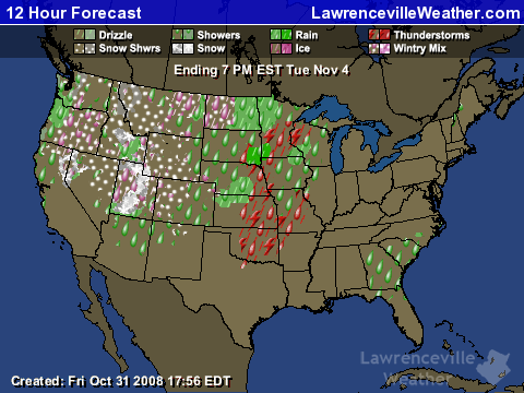
As you can see from the image above, which shows expected weather conditions from 7AM through 7PM on Tuesday, there’s a reasonable chance for some light rain while the polls are open. The weather pattern sets up like this: There is a low pressure system that tonight is bringing thunderstorms to Arkansas. Cut off from the main jet stream, the low will migrate south over the weekend, until it reaches the Florida Panhandle. Then, it moves northeast into Georgia.

Meanwhile, high pressure moves down from New England, setting the stage for cold air damming, or the wedge. This weather phenomenon occurs when colder, high pressure air is trapped against the Appalachian mountains as the lower pressure, lighter air moves on top of it. It generally means cool weather with lots of clouds and drizzle. Right now, a high of 66 is predicted for Atlanta, but that could go down depending on the strength of the wedge.

Bad weather is also likely to affect the battleground states of Montana, Missouri and Arizona. It might also affect some of the leaning states such as Colorado, where snow is expected in the mountains, with rain in the plain from Denver east. However, Ohio and Florida–the key states in the previous two elections–are now forecast to have good weather on Election Day.

How all this will affect the election results remains to be seen. Unlike previous years, many people have taken advantage of early voting and don’t have to worry about election day weather. But, if it does rain on Tuesday, keep in mind what my mother always used to say when it rained–unless you’re the wicked witch of the west you won’t melt. Bring an umbrella and vote.

Sphere: Related Content

Share

Wedge Keeps Atlanta Cooler Than Normal; Summer Weather Scorecard

Wednesday, September 17th, 2008

If you have looked at the morning weather forecasts over the past few days, you might have noticed that high temperatures did not reach what was predicted. Despite forecasts for the mid 70s today, the high in Lawrenceville didn’t make it above 68. On Tuesday, the high was 75 in Lawrenceville, and 80 in Atlanta.

Blame the whole thing on cold air damming, popularly known as the wedge effect, where high pressure at the surface is trapped by the mountains and is overrun by lower pressure. We’ve got a high located near the Georgia/North Carolina border that is interacting with lower pressure arriving from the west. Since air at high pressure is heavier than air at low pressure, the lower pressure air forms a ‘blanket’ over the high pressure, causing cloudiness, lower temperatures, and winds from the east.

Tuesday, the damming effect wasn’t as pronounced, and ended just west of Gwinnett, so Atlanta wasn’t affected, and got warmer than it did further east. As the high moved further south, it got stronger, affecting a wider area today.

(more…)

Sphere: Related Content

Share

Rain Mostly a Bust

Wednesday, August 13th, 2008

Well, it looks like those predictions for all that rain this week didn’t exactly come true. Despite predictions of one to two inches made as late as Monday, most of the Atlanta area received less than an inch of rain from the storm.

The official rain gauge in Atlanta recorded .53 inches of precipitation as of 8 this morning. Other locations include Chamblee with .28 inches, Marietta with .24 inches, Macon with .69 inches and Athens with .35 inches. Isolated areas got soaked, though. Brunswick reported 1.6 inches, Cordele had an inch and a half, Plains had 2.37 inches and it looks like West Point got the day’s highest rainfall, with 2.97 inches. However, a few miles away in Columbus, then had .7 inches, so the possibility of ‘isolated heavy rainfall’ did come true in a few locations.

I guess you could say that in the battle of pressures, the high pressure won out. The dry air and the very nice weather we had over the weekend had to be forced out in order to get the moist rain producing tropical air into the northern half of the state. As late as 4 PM, the dew point hadn’t gone above 60, and we had a case of cold air damming–unusual in the summer–where the high pressure was being forced up against the mountains, giving the low pressure nowhere to go.

All of this could result in another typical winter phenomenon, a Nor’Easter running up the Atlantic coast, bringing heavy precipitation to the mid-Atlantic and New England. The low will seek its escape out into the Atlantic and keep moving north, bringing unneeded rain to the northeast. Between the CAD (which because it was summer, wasn’t really that cold) and the Nor’Easter, this storm was more typical of what you would see in the winter, instead of the middle of August.

Of course, Fall is rapidly approaching. We’ve finally started lowering both the daily average high and low temperatures, and we’ve lost almost an hour of daylight since the beginning of summer two months ago. Due to the drought the leaves on my trees are dropping, making it look more like mid-October than mid-August, but that’s not due to the cooler weather.

The best hope for drought relief remains tropical weather, and it looks like we may see some activity beginnining this weekend. A tropical wave east of Cuba is drawing attention, and could develop into a tropical storm by the weekend. Some models have it crossing Florida into the gulf, while others keep it along the Atlantic. The northeast quadrant of a storm is the one that tends to get the most rain, so for really beneficial rainfall in north Georgia, we really need to see something come from the gulf, rather than from the Atlantic. If this wave doesn’t do the trick, however, there will likely be others behind it.

Sphere: Related Content

Share

The Wedge Is Back for This Week, but Look Out for Cold to Follow

Sunday, April 6th, 2008

If you are like me, you were probably looking forward to the predicted sunny skies this afternoon, which obviously didn’t happen. The moist air left over from Saturday’s rain remained in place as the slow moving cold front that brought the rain stalled across south Georgia. This kept the clouds in place and kept the temperatures cooler than expected.

If you were hoping for bright April skies this week, it looks like that won’t happen either, and there is a possibility of rain affecting the upcoming Masters Tournament in Augusta this weekend. For the first part of the week, we’ll see another wedge keep temperatures cooler than normal, with a good chance of fog and drizzle in northeast Georgia.

The wedge moves out on Wednesday, leaving us with a pleasant day for the first round of the Masters on Thursday, but setting us up for a chance of showers and thunderstorms through the weekend. Right now, it looks like the greatest chance of rain is in the western part of the state, but golfers could see rain on Friday and Saturday. The storm system moves out Saturday night, leaving better weather for Sunday.

The week of the 13th promises to be interesting, at least by the early forecasts. There’s a good possibility that cold Canadian air will make one last stand, with a chance of a very late freeze for the first part of the week. Both the 6-10 and 8-14 day outlooks are calling for colder than normal temperatures, and Accuweather is calling for lows in the mid 30s a week from Monday and Tuesday. If you were planning to get your annuals out this week, it might be a good idea to hold off until the forecast becomes clearer as the week wears on.

(more…)

Sphere: Related Content

Share

Cold Air Damming Makes Freezing Rain Likely Thursday

Tuesday, January 15th, 2008

It looks like things could get fairly nasty Wednesday Night and into Thursday for much of the Atlanta area north of Interstate 20, and especially for the northeast counties, including Gwinnett.  An incoming low pressure system in the Gulf of Mexico will bring precipitation to Georgia beginning Wednesday morning.  Meanwhile, the high currently over the eastern part of Kentucky will move northeast, running into the Appalachians, and causing a ‘wedge’, or cold air damming to affect northeast Georgia.

What happens is that the colder air gets trapped on the western edge of the mountains, and the approaching lower pressure, warmer air slides above the colder, heavier air. You can tell when we’re in a CAD situation when the wind comes from the east, and it doesn’t warm up much during the day.

The presence of warm air above cooler closer to the ground tends to favor the formation of sleet or freezing rain, since the warm air layer will melt any snow as it passes through, while the cold air close to the ground will either re-freeze the precipitation, or cause freezing when the water hits the surface.

In the last day, forecasters have increased the total amount of expected precipitation from the storm to almost an inch, while dropping the low temperature Wednesday night, especially in the northeast counties most affected by the wedge.

(more…)

Sphere: Related Content

Share