Get Forecast For:
Lawrenceville Weather

Is the North Georgia Drought Finally Over?

Thursday, May 7th, 2009

Compared to the past few years, the weather this spring in North Georgia has been wet. Virtually the entire state reported above-normal rainfall in April, which followed a wetter than normal March.

Some unofficial reports of rainfall totals in April were over ten inches in South Georgia, while the highest official total was 7.3 inches in Alma, over four inches above normal. Atlanta was 1.56 inches above normal for April, and Athens had 1.12 inches above normal precipitation.

May has gotten off to a wet start as well. As of May 6th, Atlanta had recorded 2.05 inches of rain, which is 1.31 inches above normal for the first week in May. With this morning’s storms and chances of more wet weather still ahead through the weekend, we are close to reaching the 2.8 inches of precipitation recorded for all of May, 2008, and will have more May rain than since at least 2004. Normal May rainfall in Atlanta is 3.95 inches for the entire month.

Lake Lanier continues to fill as well. The lake level is at 1064.95 feet at Buford Dam, 7 inches above where it was when the current rains started a week ago, and just six feet below full pool.

The latest drought outlook from the Climate Prediction Center says,

Several inches of precipitation are forecast in the short-term for the last vestiges of the once expansive drought that covered the interior Southeast. Given the expected heavy precipitation through the forthcoming weekend, and nothing indicating enhanced probabilities for significantly below-normal rainfall through the end of July, it seems likely that we will finally be able to close the books on this protracted and at one time serious, large-scale drought that has been affecting the Southeast for the last 3 years.

And, State Climatologist David Stooksbury reported earlier this week that conditions on Lakes Lanier and Hartwell have improved to mild drought from moderate drought because of the increasing lake levels. The rest of the state is drought free. He reports above normal soil moisture for most of the state, and normal to above normal stream flows. He says,

May is typically one of the drier months in Georgia. Additionally, with high temperatures routinely in the 80s and plant water use very high, moisture loss is accelerated. We normally expect the soils to start to dry out this month.

As we progress through the summer into the middle of fall, moisture loss from the soil – due to evaporation and plant use – is normally greater than rainfall. With normal weather over the next several months, Georgians can expect to see a drying of the soils. However, this is normal and does not mean that Georgia is heading back into a drought.

Sphere: Related Content

Share

March Rains Largely End North Georgia’s Drought

Monday, March 30th, 2009

Widespread March rainfall has caused all but a few North Georgia counties to become drought free. According to information from Georgia Climatologist David Stooksbury, the only counties still considered to be in moderate drought are Union, Towns, Rabun, Lumpkin, White, Habersham, Hall and Stephens. A few northwest Georgia counties are drought free, while the remainder, including Gwinnett, are classified as abnormally dry, mostly due to the long-term rain deficit we’ve experienced for the past four years.

Atlanta has recorded 7.12 inches of rain in March, over two inches more than normal. For the year, the deficit is 1.09 inches. With 7.03 inches of March rain in Athens, the Classic City is only .39 inches below normal for the year. With an additional inch or so expected Tuesday through Thursday, both cities could be back to normal rainfall by the end of the week.

While the plentiful precipitation seems to have encouraged Atlanta area flora to show their spring colors more strongly than in recent years, the hidden subtext of the drought picture, which I assume will be reflected in Thursday’s drought monitor, is that the counties that make up Lake Lanier’s drainage basin, including Hall and Habersham, are still in a moderate drought. Last week’s rainfall raised Lanier’s level by over a foot, but the lake is still ten feet below full summer pool.

The current climate pattern of a weak La Nina transitioning to neutral is responsible for much of the changes to a wetter spring. According to Stooksbury:

Currently the climate pattern is a weak La Niña pattern tending toward a neutral pattern. A typical weak La Niña spring brings wet weather across the northern piedmont into the mountains, just like north Georgia experienced in March.

Moisture conditions are in good shape across most of the state’s northern half, but the typical moisture recharge period will be ending soon. By the middle of April, plants are in full spring growth and using tremendous amounts of water.

By the middle of April we can expect the soils to begin to dry because of increased plant water use. Additionally, by the middle of April, temperatures are routinely in the 70s to low 80s. This means that evaporation will increase. This late spring and summer drying is normal.

The outlook is for a few more weeks of recharge followed by the normal drying of the soils due to plant water use and evaporation. May is usually a dry month. Little recharge is expected from May through October, but this is typical for Georgia.

The big unknown is what the tropics will bring Georgia this summer and winter. Much of the state’s late summer and fall rain comes from tropical disturbances. Without moisture from the tropics, August through October can be very dry. At this time there are no clear indications of how much rainfall the summer will bring.

Sphere: Related Content

Share

Warm Weekend Weather Will Have Georgians Thinking Spring

Tuesday, March 3rd, 2009

I was winding my way through the big box home center today picking up a few things, when I noticed the racks of petunias, geraniums and even tomatoes in gallon containers waiting to be sold to unsuspecting consumers.

We’re about to see a real warm up starting on Thursday. By the weekend, we’re likely to see high temperatures in the mid-70s, with lows around 50, which will continue through the middle of next week. Undoubtedly, these tender annuals will be picked up by eager gardeners ready to start Spring. These same folks are likely to be disappointed by the following weekend, when nighttime lows drop below freezing again.

Now, I’m as ready for spring as the next person. And, I’m hoping that Randy’s Nursery will open this weekend so I can get a start planting perennials, which unlike the tomatoes and geraniums won’t expire when the temperatures drop.

State climatologist David Stooksbury recently issued his spring climate outlook, which he says will be influenced by a change from a neutral pattern into a mild La Nina pattern. For Georgia, Stooksbury says, this means it’s likely to be dry in the middle and southern portions of the state, while north of a Carrolton to Elberton line, the climatology is likely to produce normal rainfall. In the Georgia mountains, it’s likely to be either very wet or very dry, depending on the position of the jet stream.

Temperatures are likely to vary widely over the next month and a half:

As far as temperatures are concerned, we can expect a continuation of a wide range, especially through the middle of April.

The date of the last killing freeze, or 28 F or below, or the last frost has no relationship with the climate pattern. Knowing that Georgia is currently under the influence of a weak La Niña tells us nothing about when the last freeze will occur.

Just as important, a warm March does not tell us anything about the likelihood of a late freeze. The 2007 Easter freeze is a prime example. March 2007 had been very warm and most plants had broken their dormancy. Then a devastating freeze hit in early April.

Stooksbury also points out the snow and ice storms are not that unusual in March, either.

So get out and enjoy the upcoming weekend. Within a week’s period Georgians will have been able to play in the snow and break out the shorts and T-Shirts. That’s one reason I like Georgia weather. But, hold off on those annuals until after the Master’s tournament in April.

Sphere: Related Content

Share

First Two Months of 2009 Not Promising for Drought

Thursday, February 26th, 2009

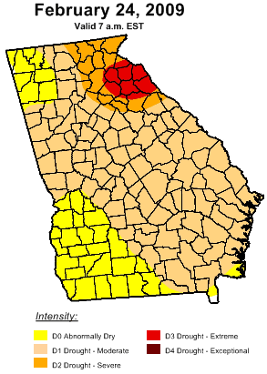
Georgia Drought, 2/24/09As far as the weather goes, winter is almost over, and with it, the best chance for reducing Georgia’s long-term drought. However, looking at the rainfall we’ve had for the first two months of the year, we are woefully behind where we should be. As of this morning, we’ve had 4.39 inches of rain in Lawrenceville, compared to a normal of 9.19 inches, or 48%. Atlanta is doing even worse, with only 3.84 inches, or 42% of normal rainfall.

Most of the state is now listed as being in some sort of drought, as you can see in the map to the right. The biggest change over the last week is that the part of the state in moderate drought has increased from 30% to 76%. Less than 1% of the state is drought free.

In his latest assessment, state climatologist David Stooksbury says,

The cool season – October through April – is critical for the state. That’s when it typically receives moisture recharge to the soils, groundwater, rivers and reservoirs. Without significant rain in the next two months, Georgia is primed for another year of drought.

The major reservoirs of Lanier, Hartwell, Russell and Clarks Hill remain near record lows with diminishing hope for recharge unless there is a major weather pattern shift over the next few months.

This weekend does promise to bring some relief, with rain predicted for much of the northern half of the state on Friday and Saturday. Accuweather is forecasting 2.25 inches of rain for Gwinnett over the period, while the weather service says there could be nearly four inches of rain in parts of north Georgia, with the western half of the state more likely to get the heaviest rainfall.

However, once this system moves on through, the outlook for much of March, and indeed the Spring months is for drier than normal conditions for much of the Southeast. Lake Lanier stands at 1056.9 feet, pretty much where it was after heavy rains in early January raised the lake’s level by about three feet. Rain this weekend should help some, but it doesn’t look like we’ll be getting back to normal any time soon.

Sphere: Related Content

Share

Damp Weather Pattern May Move Out with a Flourish

Monday, January 5th, 2009

The metro Atlanta area is about to see a change in the weather pattern that has brought greater than normal precipitation, and mostly warmer temperatures to north Georgia for the past month. Much of December featured an upper level trough in the west and a ridge in the east, meaning by and large cold in the west and warm in the east. It’s the big ridge over the southeast that has prevented much of the cold from reaching the Atlanta area, and has caused fronts to stall in the Atlanta area.

Right now, it’s 65 degrees here in Lawrenceville, but just to our west in Huntsville, Alabama, it’s 20 degrees cooler. A bit further north, in Lynchburg, Tennessee, it’s 25 degrees colder than here. Tonight, tomorrow and Wednesday, we’re set up for a storm that could be similar to the rain we got back on the second week of December, as Gulf moisture travels up the spine of the front. right now, it looks like the heaviest rains will be to the north and west of Atlanta, but we could still get between 1.5 and two inches before it all ends sometime Wednesday as the cold front is finally able o overpower the southeast ridge.

The weakening ridge marks the pattern change that puts a ridge in the west and a trough in the east. That means we’re likely to have more normal Winter temperatures and most likely less rainfall than we’ve seen recently. If we do get below normal temperatures, it’s most likely to be next week rather than this week. After the middle of the month, temperatures could moderate somewhat, although I’m reluctant to call for a heat wave.

Is there a chance of snow in the forecast? If you believe the GFS model, we might see some next Tuesday or Wednesday.

State Climatologist David Stooksbury said last week that it might be time to reconsider what normal rainfall should be for Georgia, noting that the overall precipitation pattern in the southeast US has been drier than normal since 1979. The Weather Service uses the period from 1970 through 2000 to calculate its normal rainfall, and eight of the last eleven years have seen rainfall less than the normal 50 inches per year. In any case, all this rain has been good for Lake Lanier. The current level is 1053.3 feet, which is almost three feet higher than it was before the rains started in December. Look for the level to go even higher with this week’s rain.

Sphere: Related Content

Share