Get Forecast For:
Lawrenceville Weather

September and October Second Wettest Ever for Atlanta

Sunday, November 1st, 2009

With October now in the history books, it’s pretty clear that north Georgia had its second very wet month in a row. Athens reported 9.14 inches of precipitation, with only 1937 being wetter, with 11.23 inches. In Atlanta, Hartsfield-Jackson airport recorded 8.71 inches, with only 1995′s Hurricane Opal bring more October rain than last month, with 11.04 inches.

Here in Lawrenceville, I recorded 7.47 inches, in Gainesville, they had 11.2 inches or rain, with Macon and Columbus still top-ten wet, with 6.37 and 6.39 inches of precipitation, respectively. Even more of an eye-opener is the two month totals for September and October, shown graphically below:
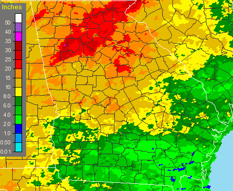
September-October, 2009 Georgia rainfall

The two month period saw 17.65 inches of rain fall in Atlanta, second only to 1888, when 18.25 inches fell. Both Athens and Macon had their wettest September and October ever, with 19 inches in Athens and 17.05 inches of rain in Macon. Columbus had it’s third wettest September-October with 11.69 inches, and in Lawrenceville, which received some of the heaviest rainfall in the September flooding, I recorded 23.3 inches for the period.

Usually heavy late-summer rain is brought about via tropical storms or hurricanes affecting Georgia, but not this year. (This season has had the least tropical activity since 1997, with one month to go before it ends). And of course the one benefit to all the rain is that it returned Lake Lanier to full pool, marking a recovery from the drought.

October also proved to be cooler than normal for North Georgia. Atlanta’s average temperature of 61 degrees was 1.9 degrees cooler than normal, while in Athens, the average of 60.7 degrees was 1.1 degree less than normal. Here in Lawrenceville, I recorded an average of 59 degrees, cooler still.

It looks like we’ll have a chance to dry out during the first two weeks of November, though, and perhaps see temperatures a bit warmer than normal for mid-Autumn. The short term forecast is for dry weather, while the 6-10 and 8-14 day forecasts are also calling for warm and dry. For the month as a whole, the Climate Prediction center calls for a 33% chance of drier than normal conditions, and equal chances of above or below normal temperatures.

Enjoy November, because the winter forecasts from December through February I’ve seen are almost unanimous in their call for a cold, wet winter.

Sphere: Related Content

Share

More Rain for North Georgia

Monday, October 12th, 2009

It’s starting to feel like we really are making up for all that missing rainfall from the drought. Today’s rainfall here in Lawrenceville of 2.52 inches brings the total rain for October here to 4.55 inches — more than an inch above what would be expected for the entire month. It’s the wettest October in at least five years.

Atlanta set a new rainfall record for October 12th today, with 2.5 inches. That makes the yearly rainfall for Hartsfield Airport to 50.68 inches. Normal annual rain for Atlanta is 50.2 inches, so we’ve met that milestone with nearly a quarter of the year to go. Athens also set a rainfall record for the day with 3.83 inches. The previous October 12 rainfall record for both cities was set in 1994. Lake Lanier is now at 1070.58 feet above sea level, having gained over half a foot during the day. The lake is now less than half a foot from full pool, although it would take a lake level of 1085 feet before it would be considered flooded. The last time Lanier was at full pool was in September, 2005.

Flooding is occurring, though. Suwanee Creek in Suwanee is at 9.79 feet, with flooding beginning at 8 feet. Big Creek in Alpharetta and the Chattahoochee River in Vinings are also at flood stage. I saw where the Yellow River had escaped its banks into the flood plain in my area.

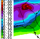
Preciptation Prediction through ThursdayUnfortunately, it looks like we’re up for more rain on Wednesday. After a relatively pleasant day tomorrow, the rain will return, and according to the latest estimate from the Weather Service, shown at right, we could have another two to two and a half inches through Thursday evening, with higher amounts in the northeast Georgia mountains. If that scenario does pan out, expect more possible flooding, since the ground will be even more saturated than when the rain started this morning.

Once all the rain does go away on Friday, we will be in for some cooler weather over the weekend. The cold Canadian air that has brought an early Winter to much of the Plains states is moving east. Right now, overnight temperatures for the weekend are predicted to be in the mid 40s, but I wouldn’t be surprised if they end up a bit lower than that.

Speaking of cold in the west, I’ve got to take note of the fact that in Denver, Colorado, temperatures dropped to a chilly 18 degrees Saturday morning, and didn’t get out of the 20s, forcing the cancellation of the third game of the baseball playoffs. The low temperature was the coldest it’s been so early in the season in Denver. Temperatures also dropped below the freezing mark this morning in Chicago. It was 34 in Dayton, Ohio and 28 in Grand Rapids, Michigan on Sunday morning. Record cold temperatures were felt in Montana, and the cold in Idaho may make it difficult for farmers in Idaho to harvest their potato crop.

It doesn’t look like things are going to get much better in Georgia at least through the end of the month. The 6-10 and 8-14 day forecasts call for continued chances of above normal precipitation, and colder than normal temperatures in the 6-10 day period. Long-range winter forecasts call for a cold and wet winter in the southeast, a topic I’ll try to cover in more detail later in the week.

Sphere: Related Content

Share

Rainfall Totals from Around Atlanta

Monday, September 21st, 2009

The weather service has reported 24 hour rainfall totals for North Georgia ending at 8 AM on Monday, September 21st. Here are some highlights:

Athens: .65 inches
Atlanta: .87 inches
Canton: 3.95 inches
Carrollton: 7.66 inches
Cartersville: 1.68 inches
Cleveland: 3.68 inches
Chamblee: 4.28 inches
Cumming: 1.80 inches
Doraville: 5.37 inches
Gainesville: .82 inches
Lafayette: 7.20 inches
Marietta: 3.54 inches
Rome: 2.61 inches
Sautee: 5.18 inches
West Point: 4.33 inches

Sphere: Related Content

Share

Incredible Rainfall Pounds Atlanta

Monday, September 21st, 2009

If you think we had plenty of rain over the last six days, it looks like day seven is the one to beat them all. As of 6:50 this morning, my rain gauge is reporting 5.84 inches of precipitation fell…this morning. The AJC is reporting that Spaghetti Junction is closed because of heavy rain (both I-85 and I-285). In Gwinnett, two feet of water is blocking the intersection of Scenic Highway and Sugarloaf Parkway, and there is additional flooding in downtown Lawrenceville. The weather service is reporting 7 inches of rain in Lilburn, over 3 inches in downtown Atlanta, and 9 inches in southwest Atlanta.

So, that brings the total rainfall for the last week to 12.57 inches. In Atlanta, 3.72 inches of rain fell on Saturday, breaking a record. I’m sure there will be more records set today. Flash flood warnings are in effect until later this morning, with flood warnings until

And if you’re wondering about Lake Lanier, it’s rising rapidly as well. After being fairly stable until the weekend, the runoff and excessive rain has cause the lake’s level to rise by a foot since Sunday morning, and I imagine it will continue to go up. The current level is 1065.81 feet.

Sphere: Related Content

Share

Rain, Rain Go Away

Thursday, September 17th, 2009

Much of the southeast US has been caught up in a blocking pattern over the past few days, with an upper level low pressure system stuck over the Mississippi/Louisiana area causing wet, tropical air to be brought up from the Gulf of Mexico. While there’s no tropical storm bringing in all this precipitation, the effects are much the same.

In fact, the three day total rainfall I’ve recorded at my home of 4.45 inches is the largest three day total since exactly five years ago on September 16-17, 2004, when 4.73 inches of rain fell as the remnants of Hurricane Ivan came through the state. And it’s possible that we’ll get even more rain later today to beat that record.

Rainfall amounts are varying widely across north Georgia. While I don’t yet have official readings for today, yesterday, Atlanta recorded .76 inches of rain, while I received 2.23 inches. Other areas with a lot of rain yesterday include Chamblee with 1.99 inches and Charlie Brown field with 1.16 inches.

Unfortunately, the rain is going to stick around through the weekend and possibly into the first part of next week before we get to a dry spell. With the ground already saturated from rain, much of Georgia from the Atlanta metro area south has been placed in a flood watch until Saturday morning. As of now, there are no reports of flooding, but it’s certainly possible.

Sphere: Related Content

Share