Get Forecast For:
Lawrenceville Weather

Archive for the ‘Winter 2006-07’ Category

Next Threat for Wintry Weather Tuesday

Saturday, February 10th, 2007

Friday’s threatened wintry mix didn’t work out, with temperatures largely staying above freezing, and little to no precipitation in the metro Atlanta area. By my count, that’s now three potential storms over the past few weeks that didn’t really cause any problems. Don’t let your guard down yet, however, since it appears that winter isn’t over yet, despite what the groundhogs said.

After a relatively mild weekend, the next storm sets up for Tuesday into Wednesday. A low pressure system heads towards Georgia on Tuesday, bringing up to an inch of rain. The forecast gets tricky though, because the models are trying to figure out exactly how far south the low gets.

If it tracks to the north, then all we get is rain, and New York and New England are in for a major snowstorm. If it tracks further south, then north Georgia gets more precipitation plus a chance of a wintry mix Tuesday night, and the heaviest snow will be in the Carolinas through Washington, DC. Right now, the most precipitation is forecast for Tennessee, and there’s a chance of a wintry mix on a line from Chattanooga to Athens; just touching the northern part of Gwinnett. But, the storm bears watching, because, as usual, we are on the borderline.

Temperatures so far this month are about five degrees below normal. The intense dip of the northern jet that’s been bringing all the cold may lessen by the President’s Day, but after Tuesday’s weather and until the 20th, it’s going to continue to be colder than normal, with highs struggling to reach 50 degrees. The consensus I heard at the Southeastern Flower Show yesterday was that while a month ago, we were a month ahead of the normal springtime blooming schedule, since then, things have slowed down, and we may now be behind. Last year on President’s day, the cherry trees were blooming along Ronald Reagan Parkway: I bet that when they Run the Reagan next Saturday, there’ll be nary a bloom in sight.

Sphere: Related Content

Share

Surprise Wintry Weather Possible Friday

Thursday, February 8th, 2007

In somewhat of a sudden reversal, the Weather Service has now issued an advisory for Friday, calling for the possibility of some type of wintry weather during the day. The thinking goes that overnight, we will see low temperatures around 30 degrees. Because of clouds from the incoming storm, we won’t get much warmer during the day, and when the precipitation arrives, it could be snow, sleet, rain, or a combination of the above–a wintry mix.

This is a pretty big change from what was forecast as late as this morning. At that point, we were looking at highs in the upper 40s, and a slim chance of any rainfall at all. In fact, forecasters were warning of the possibility of having to issue a red flag warning due to low relative humidities.

Part of the problem is that the models used to predict the weather have been all over the map for the last few days, especially the GFS, which is the model the weather service relies on most. Unlike our storms earlier this month, this one is approaching from the north, not the Gulf coast.

There are still a lot of variables that could make this a problem or a non-event. It looks to me, as usual, that the temperatures we actually have will make the biggest difference. The forecast hinges on some of that real cold air up north making its way into north Georgia, and keeping daytime temperatures lower than what we’ll see when the sun rises. Also, the exact amount of precipitation is likely to be small.

I wouldn’t go out and buy your bread and milk yet. If there is a storm, it will most likely hit north of I-285 and I-85, with more southerly areas getting mostly rain. Once the storm passes through Friday night, the weekend won’t be too bad, although overall, we aren’t done with the cold weather yet.

Sphere: Related Content

Share

Freezing Rain Wednesday Night?

Tuesday, January 16th, 2007

There’s a reasonable chance that metro Atlanta might get its first wintry weather Wednesday night and into Thursday, but the forecast is tricky, and a lot of what will happen will depend on exactly how conditions set up.

During the day Wednesday, North Georgia will be under control of a high pressure system located over Virginia. This will make for a chilly day again. Meanwhile, a low pressure system is moving east. It’s the same one that has brought freezing rain to Texas earlier this week. Whether we get a major winter event depends on how these two systems interact.

As the warm, moist air moves into Georgia, it will meet the colder air. Since the colder air is heavier than the warmer air, it will remain below the warm air. This effect is called Cold Air Damming, or popularly, ‘the wedge’. The possible effect is that instead of temperatures rising with the incoming rainfall, it will remain cold enough at the surface to cause sleet or freezing rain.

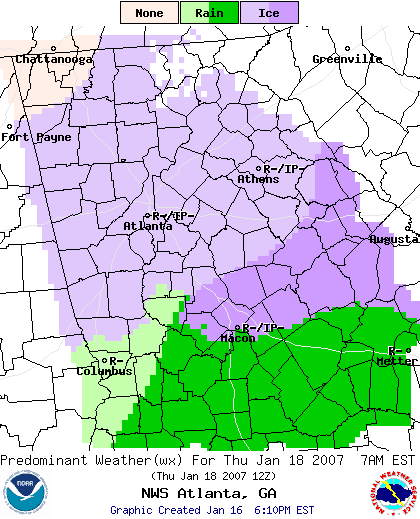
Below is the Weather Service graphical forecast for 7 AM on Thursday:

You can see that below Macon, there will be heavier precipitation, and it will be all rainfall. There’s an area north of that that may see heavier icing, since it will be in the more active part of the rainy sector, while also under the influence of the wedge. North of a line from Columbus to Athens, including Gwinnett County, freezing rain is also predicted.

So what happens on Thursday morning is a function of how strong a wedge develops, and how fast the precipitation moves. Since the ground is warm because of the springlike weather we saw before today, there isn’t likely to be any accumulation on the ground. However, if we do get freezing rain, it will affect trees and power lines, and things could turn nasty. If it’s too cold, we get sleet, which won’t be a problem. And, if the wedge is weak, we may get all rain as temperatures close to the surface remain above 32 degrees.

Stay tuned…

Sphere: Related Content

Share

Warm Temperatures Ending Soon

Saturday, January 13th, 2007

Much of the eastern half of the country has experienced unusually warm weather so far this winter. New York City finally saw its first flakes of snow this week–the latest first snowfall ever recorded. Temperatures in North Georgia so far this month are between seven and eight degrees above normal. This weekend, the Atlanta area could see temperatures around 70 degrees. Newspapers have run articles lamenting poor sales of winter coats and snow blowers.

If you’re thinking that it’s time to sharpen your lawnmower blades and get out the gardening gloves, you would most likely be wrong.

The split-flow upper air pattern that has been keeping the cold air up in Canada has begun to change, and at least one prominent meteorologist thinks that we could be seeing one of the coldest 30 day periods in the last 50 years.

Accuweather put out a press release on Monday featuring comments from forecaster Joe Bastardi. Bastardi says “the mild weather we’re experiencing now will be a distant memory,” and notes cold air will be moving across the country the week of the 15th, and a cold weather pattern will dominate the second half of the month.

The central part of the country is seeing this change now, and they are going to have a long slog this weekend. A slow-moving front stretches from East Texas to Maine, and is the dividing line between cold and warm air. It’s also bringing a lot of precipitation, as snow in the north and west, and as rain in areas stretching from Louisiana through southern Ohio. In between there’s going to be a major ice storm stretching from the Texas-Oklahoma panhandle through parts of Illinois, Indiana and Ohio. Once all of this moves through by the middle of next week, the cold air will settle in.

Georgia is likely to miss all the weather excitement, at least through Monday evening. By that time, we may see some rain as the front exits the area, and the real cold air will stay out of the way for a few more days. But, by the week of the 22nd, we could see highs only in the mid 40s, and lows in the low 20s; much colder than normal.

Sphere: Related Content

Share

One More Week of Warm Weather – But the Real Cold May Be in February

Thursday, December 14th, 2006

I hope you’ve had a chance go go out and enjoy the warmer than normal temperatures we’ve had this week. We’ve seen temperatures about ten degrees above normal, and it looks like temperatures could get into the low 70s over the weekend.

Of course, it can’t go on forever. The pattern is likely to change a week from now, after a good chance of rainy weather midweek next week. After that, look for temperatures approaching normal to slightly below normal through the end of the year.

If you want to get a peek at what we could see for the rest of the winter, check out this graphic. It shows the expected deviations from normal for temperatures for the next six months, based on the CFS climate modeling system developed by the National Weather Service.

The models show a colder than normal December in Georgia–we are running about 3 degrees cooler than normal this month– followed by a normal to slightly cooler than normal January, a better chance for a cold February, a normal March, and a cold April. While these aren’t official forecasts, they do give some indications of what models say we’ll see this winter.

Even though the winter solstice is one week away, today was the first day since last July that the sun set later in the day than it did yesterday. Although we’ll see later sunrises for another three weeks, we’ll gain about ten minutes of evening light between now and the first of the year.

Sphere: Related Content

Share