Get Forecast For:
Lawrenceville Weather

Archive for the ‘Global Warming’ Category

Looking Ahead to February and Early Spring

Saturday, January 23rd, 2010

We’re now about three fourths of the way through January, and just about two thirds of the way through Winter. December was 2.7 degrees colder then normal (15th coldest on record) and the second wettest on record, with 9.1 inches of rain. So far in January, Atlanta Hartsfield-Jackson airport is 5.4 degrees colder than normal, but with 2.19 inches of precipitation, only 54% of normal. With more rain predicted for Sunday, and again at the end of the week, we could easily get back to normal January precipitation of 5.03 inches. The verdict for the first part of Winter would have to be colder and wetter than normal.

Looking forward to February, and anticipating the groundhogs next month, the early part of spring, it looks like we can expect more of the same. The Climate Prediction Center released its February outlook earlier this week, which is reproduced below:
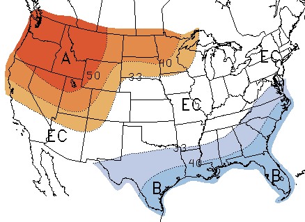
February Temperature Outlook

February Precipitation Outlook

As is typical for El Nino winters, it’s likely to be colder than normal for much of the Southeast, and warmer than normal for the Northwest. The remainder of the country could be above or below normal. On the precipitation side, most of the southern half of the country will be wetter than normal, with equal chances of dry or wet weather in the north. The greatest chance of excessively wet weather is in southern California and Arizona, not welcome news for an area which has seen extensive flooding this week.
(more…)

Sphere: Related Content

Share

A Climate Change Scandal?

Tuesday, November 24th, 2009

Last week, someone managed to access emails and other information from the Climate Research Unit of Britain’s University of East Anglia. The CRU is charged by the British Met Office to investigate global warming, and is responsible for much of the research into the field. These emails and files were posted to a public site, and the evidence they provide does not reflect well on the scientific method of the researchers.

Among other things, the files show that CRU scientists and their partners across the world tried to silence those who didn’t agree with the CO2/Global warming theory, tried to prevent others from accessing the data they used to make their predictions and used methods to falsify data that was later presented to the United Nations IPCC. Officials with the university confirm that information was taken from their servers, and the emails, etc. appear to be genuine.

If all this is true, it poses a real problem for the scientific community and for the theory that climate change/global warming is a big problem.

Here are some links to more information:

Excerpts from the emails exchanged
Evidence that the “Hockey Stick” chart showing future increases in temperature used deceptive data
Comments in program code used to create temperature series are further evidence of data manipulation
Wall Street Journal says climate scientists are trying to hide the truth
Three things you must know about Climategate
This research is the foundation for new, expensive regulations on the US economy

There’s a lot more out there, if you search for it. It will be interesting to see how this plays out, especially with the Copenhagen talks coming up next month.

Sphere: Related Content

Share

Storms and Rumors of Storms

Friday, January 30th, 2009

While the last two weeks have been relatively quiet weather-wise in Atlanta, that certainly hasn’t been the case elsewhere in the country. a massive storm earlier this week brought snow, then ice, then more snow to a wide area from Arkansas to Pennsylvania, with Kentucky perhaps suffering the most. State officials there are calling the power outage caused by the ice storm the worst in the state’s history. Chicago has had six or more inches of snow on the ground for the last 20 days, a top ten record, and as of yesterday is recording its third coldest January on record, with a mean temperature of 15.8 degrees, more than six degrees below normal.

Despite a general impression of a cold January in Atlanta, it’s actually been warmer than normal. At Hartsfield, the mean temperature through today is 44 degrees, 1.3 above normal. It’s been a bit cooler here in Lawrenceville, with a mean of 42.5 degrees, but that’s to be expected. The January mean temperature in 2008 was actually over a degree cooler than this year, although 2007 and 2006 were both above normal.

After this weekend, which could be quite pleasant, we have the threat of the worst storm of the winter season. The eyes of the weather world are focusing on Monday and Tuesday, when a powerful storm will start in the southeast and move north, bringing a chance of snow to North Georgia, and likely a doozy of a storm to the mid-Atlantic states.

Most of the country’s weather this winter has been affected by the northern branch of the jet stream. In essence, the northern branch divides cold Canadian air from the (slighly warmer) air to the south. It can dive south, as we saw mid-month when we got the coldest temperatures of the season. For the first time this winter, the southern branch is also active as well. The southern branch divides warmer, tropical air to the south and the colder air to the north. When these two branches join back up, you have a good possibility of wintry weather.

The forecast models have been changing from run to run on the position of the two jet streams, and where the snow will fall, but there is a definite possibility that Atlanta could see some wintry weather on Monday or Monday night. In the worst-case scenario, we could see something like what happened in March, 1993, when the Atlanta area got over a foot of snow. Or, we could get just rain, and not much rainfall at that. Keep your eyes on the forecast over the weekend to get updates.

The History of the Global Warming Argument

The founder of the Weather Channel, John Coleman, has published a blog entry describing the history of the global warming (or climate change, to use the current PC term) debate. Coleman says there is no basis for the climate change threat, which he argues was blown way out of proportion because a researcher was looking for more government funding.

Sphere: Related Content

Share

Cold, Dry Weather to Continue Through Thanksgiving

Monday, November 17th, 2008

If it seems colder than normal for mid-November, you’re right. North Georgia got its first cold shot on Sunday after the wet weather moved out. This afternoon, another cold front passed through, although with the dry air, there wasn’t any precipitation associated with the front. Behind the front, there’s more cold air blowing in, literally. There’s a wind advisory for Tuesday, so even though temperatures in the Atlanta area will only reach the mid 40s, it will feel like the low 30s tomorrow afternoon.

We get the coldest weather of the season so far on Wednesday morning, with lows predicted in the low 20s in metro Atlanta, and freezing temperatures as far south as the Tampa area. The cold weather is unlikely to break a record, however. The record low for November 19th in Atlanta is 18 degrees, set back in 1903. Although forecasters have predicted freezing temperatures on and off for the last few weeks, much of the Atlanta area has yet to get a freeze. Wednesday should put an end to that for everybody, making the first freeze of 2008 about ten days later than normal. The record low for Atlanta in November, by the way is 2 degrees, set on November 25th, 1950. Fortunately, it won’t get that cold.

After this round of cold, things warm up, but only slightly. We should be seeing highs around 60 and lows around 40 for the last two weeks in November, instead look for highs in the upper 50s and lows in the low to mid 30s through the end of the month. What about Thanksgiving weather? The cold, dry air is going to keep most of the US dry for the next week, and following that, there’s a chance of rain moving from west to east.

(more…)

Sphere: Related Content

Share

No Sunspots in August Points to Global Cooling?

Monday, September 1st, 2008

Normally at the beginning of each month, I do a post on some of the weather records from the previous month. This month’s notable record, however, has less to do with the weather than it does with the atmosphere. The Daily Tech is reporting that August was the first month in 100 years with no sunspots. Why is this significant? Historical record show that the lack of sunspots correlate closely with periods of global cooling. According to the article,

In the past 1000 years, three previous such events — the Dalton, Maunder, and Spörer Minimums, have all led to rapid cooling. One was large enough to be called a “mini ice age”. For a society dependent on agriculture, cold is more damaging than heat. The growing season shortens, yields drop, and the occurrence of crop-destroying frosts increases.

Now, I won’t say we’re going into a mini Ice Age. But, global temperatures have not been following the model predicted by the global warming agonistes; instead the increase in temperature has leveled off in recent years, corresponding to the reduced number of sunspots. Of course, since Al Gore and his crowd can’t control sunspots, much less cow flatulence, it’s much easier to blame carbon dioxide emissions from automobiles and power plants.

Hat tip to the Drudge Report for alerting me to this article.

Sphere: Related Content

Share