Get Forecast For:
Lawrenceville Weather

Archive for the ‘Tropics 2006’ Category

The 2006 Hurricane Season Goes Out With a Whimper

Friday, December 1st, 2006

Now that the 2006 hurricane season is officially over, let’s face the facts. Despite early predictions of a season that would rival the number of storms and possible the damage seen in 2005, 2006 turned out to be a lighter than normal year. We had nine named storms, as opposed to the 15 or so predicted, and five hurricanes, as opposed to the nine that were forecast. No hurricanes hit the US coast this year. Dr. Gray described it well in his seasonal recap when he said, “Our 2006 seasonal hurricane forecast was not successful.”

Forecasters were unable to see the El Nino pattern that emerged this summer, which tends to reduce the number of hurricanes. Nor did they see the relatively dry weather in the Atlantic, including the presence of dust storms over Africa that retarded tropical development. On the bright side, the prediction of storms affecting the Atlantic coast, even though there weren’t many of them, was right on.

This season also had its share of rainmakers that either were never declared to be official storms by the National Hurricane Center, or were declared extratropical prior to causing their most intense damage. You may remember Ernesto causing a state of emergency throughout Pennsylvania, although by the time it got there, it was no longer a storm.

In any case, we’re now free to fret about the possibility of snow this winter, but be advised, the first preliminary forecast for the 2007 season is just a week away. I’ll keep you informed.

Sphere: Related Content

Share

Labor Day Weekend Stays Humid: Relief Later This Week

Monday, September 4th, 2006

The hoped for cooler temperatures and lower humidity forecast for Labor Day weekend never really happened. Various parts of Gwinnett saw showers both Saturday and Sunday, although so far Labor Day itself remains dry, despite a 40% chance of rain. Two powerful upper level lows — one over the Midwest, and the other over the northeast — combined to keep tropical air in the Atlanta area over the weekend.

The good news is that by Tuesday evening, the surface front associated with the lows, which has been planted over north Georgia, will move further south, and allow dryer, cooler air into the area. By Wednesday evening, we could see overnight lows in the 50s, which would be the first time temperatures dropped that low since back on June 7th. The pleasant weather will last most of the week, and possibly into the weekend, before another wave of rain comes in. In fact, the long range forecast from the 10th through the 16th calls for below normal temperatures, and below normal rainfall.

What could change that, though, is Tropical Depression Six, which formed yesterday in the Atlantic. It’s off to a somewhat slow start, with winds not going much above 35 MPH. However, the depression could become a topical storm by tomorrow, and a hurricane by Friday. Depending on its path, it could be causing problems somewhere along the east coast by this time next week.

Sphere: Related Content

Share

August 2006 Ends Wet, Thanks to Ernesto

Friday, September 1st, 2006

August ended up having two distinct weather patterns. For the first ten days of the month, Lawrenceville had high temperatures above 90 degrees on all but one day, and had just over an inch of rain, slightly below normal. For the rest of the month, temperatures broke 90 degrees on only 3 days, and we had over 4.5 inches of rain, more than what would be expected for the entire month.

Here are the temperature and rainfall statistics for August, 2006:

Atlanta Hartsfield had a mean temperature of 81.0 degrees, 2.1 degrees above the normal 78.9 degrees. There was 8.74 inches of rain recorded, a whopping 238% above the normal 3.67 inches of precipitation.

In Athens, temperatures averaged out at 80.7 degrees, 2.3 degrees above normal (and one day above 100 degrees). Athens received 5.77 inches of rain, or 153% of the normal 3.78 inches of precip.

Gainesville had an average temperature 3.6 degrees above normal, with 81.1 degrees. They had less rainfall than expected, with 3.39 inches recorded, compared to a normal of 3.97 inches.

And, here in Lawrenceville, I recorded a mean temperature of 78.5 degrees, and a total of 5.63 inches of rain.

Tropical Storm Ernesto has now made landfall in South Carolina, and is expected to bring plenty of rain to the Delmarva area, and into western Pennsylvania later this weekend. All in all, the storm turned out to be slightly less than what it could have been, but coming on the heels of the 1 year anniversary of Hurricane Katrina, I guess a certain amount of hype could be expected. It reminds me of what happened after the infamous January 1982 Snow Jam, when six inches of unexpected snow fell during an afternoon rush hour, causing six hour commutes. The following year, vowing ‘never again’, city leaders told everyone to go home at lunch time as a few flakes fell, and, of course, the snow never happened.

Many areas in Georgia saw a few inches of rain as a result of Ernesto. Almost half Atlanta Hartsfield’s rain for the month came yesterday, with 4.3 inches recorded — more than Charleston, SC, which reported 2.61 inches of rainfall. The huge Atlanta rainfall broke a record dating back to 1918. Obviously, a storm cell sat over the airport yesterday.

Conditions should be improving over the next few days as Ernesto works his way north. The Weather Service is predicting cooler than normal temperatures for the first half of September, and above normal precipitation for the month. Look for the next major chance of rain to occur late next week, when, of all things, the remnants of Hurricane John, about to make landfall on the west coast, drift into our area.

Sphere: Related Content

Share

Ernesto Over Florida

Wednesday, August 30th, 2006

This morning, Tropical Storm Ernesto is over southern Florida, with winds reported at 45 MPH. Fortunately for Floridians, the storm didn’t pick up much steam as it traveled between Cuba and the US. However, the storm has an eye, which you can see in the picture below, taken shortly after 8:00 on Wednesday.

By early Thursday, the storm will have moved off the Florida coast and will again be over open water. The Hurricane Center isn’t predicting that he will become a hurricane again before making landfall again in South Carolina late Thursday night, but has left open the possibility with a hurricane watch along the coast. Once the storm makes it’s second landfall, it will travel through North Carolina and Virginia as a tropical storm, and then dissipate somewhere near Erie, Pennsylvania on Sunday.

Here in Atlanta, the main effect of Ernesto will be to stall out a frontal system over our area for the next 36 hours. Our area has been sandwiched between the low pressure system to the north, and Ernesto to the south, keeping dewpoints and the chance of precipitation high. We’ll see the same type of weather through the start of the weekend. Over the weekend, it will be cooler and a little less humid, although there is a chance of a thunderstorm each day.

Sphere: Related Content

Share

Ernesto Prepares For a Direct Hit on Florida

Monday, August 28th, 2006

The latest forecasts for Ernesto show the storm returning to hurricane status after it spends today moving over Cuba. By early Wednesday morning, Ernesto will pass over the Florida Keys, and will spend the day on Wednesday raining on Florida, before emerging into the Atlantic early Thursday. By the end of the week, the hurricane will be near the North Carolina-Virginia Border.

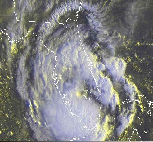
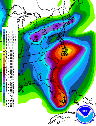
This is going to bring a lot of rain along the Eastern seaboard, as you can see from the five day precipitation forecast shown at the right. About 8 inches of rain is expected in the Miami area, and up to ten inches in the outer banks of North Carolina.

The storm is being kept from moving further west by an upper level trough and its associated surface front currently stretching from Illinois to New Jersey. That low pressure system is slowly moving south, and will likely give us rain on Tuesday and Wednesday, before it is finally absorbed by Ernesto.

The trough is not only increasing the chances that Ernesto will cause minimal havoc to west Florida, Georgia, and South Carolina. It’s also likely to be the system that breaks the back of our summer heat. After everything passes through on Thursday, temperatures will moderate to the upper 70s to low 80s for Labor Day weekend, with lows in the low 60s. With dewpoints in the 50s on Labor Day, the humidity will be gone as well.

Typically Atlanta gets a front like this that brings some relief from summer weather in mid-August, only to see a final blast of summer before things cool down permanently in mid-September. We didn’t see that this year; instead it looks like we are going to see fall-like weather enter our area to stay before Labor Day.

Sphere: Related Content

Share