Get Forecast For:
Lawrenceville Weather

Warmest Day of 2009, So Far

Saturday, June 27th, 2009

If it seems pretty warm out there, you’re right. Today’s high temperature of 95.1 in Lawrenceville at 2:20 PM makes it the warmest day of 2009 so far. Of course, the 93-95 degree high temperatures we’ve had for the last two weeks are 5-8 degrees above normal. In Atlanta, it’s been over ten days since the low temperature dropped below 70 degrees, another sign of a heat wave. For the month to date, Atlanta is 2.9 degrees above normal, with an average temperature of 79.5. In Lawrenceville, where nighttime temperatures don’t have the same heat island effect as Atlanta, the average is 77.4 degrees.

All of this isn’t being helped by the lack of rainfall — none here in the last two weeks. Now I know that it has rained in places around Atlanta — just not here. Rain chances increase from this afternoon to tomorrow evening, but after a cold front passes through Sunday night, it’s back to warmer than normal temperatures and dry weather for the work week.

Sphere: Related Content

Share

Possible Record Temperatures Could Give Way to Cooler Weather

Thursday, June 18th, 2009

There is a possibility that we might be seeing some of the warmest weather of this summer over the next few days. With temperatures in the mid 90s today and in the upper 90s in metro Atlanta on Friday and Saturday, we will be seeing the warmest weather since August 6th, 2008, when temperatures reached 94 at Hartsfield Airport, and 99 here at my home thermometer in Lawrenceville.

The warmest temperatures of 2008 were also recorded in June, with the high for the year of 98 on June 9th in Atlanta. Today’s record high temperature was 101 degrees, set back in 1944. A warm stretch back in 1933 set the records for Friday, Saturday and Sunday with 99, 98 and 98 degrees, so we will be coming close to breaking a temperature record.

After the official start to summer on Sunday, we’ll be in for more normal temperatures, with highs in the upper 80s predicted for next week. In the longer term, however, the trend may be towards lower then normal temperatures. The Climate Prediction Center’s July outlook released today calls for a 33% chance of cooler than normal weather over much of the Southeast, including all of Georgia. The three month outlook through September indicates equal chances of above or below normal temperatures for the east coast, except for southern Florida. Above normal precipitation is forecast in July south of an Atlanta to Columbus line, so it looks like south Georgia will continue to be wet. South-central and southeast Georgia had the most rainfall on record for the March, April and May time period.

Sphere: Related Content

Share

Warmest Day So Far This Year / Updated Hurricane Forecast

Wednesday, August 6th, 2008

The August heat wave looks like it will go on through Thursday, but at least here at my house, today was the warmest day so far in 2008. It got up to 99 degrees (well, 98.7) at 2:10 PM, topping the 97.1 reached on both June 8 and July 10. It could have been worse though: with the dew point in the low 60s, the heat index was only 102 degrees.

Temperatures reached the century mark today in Augusta, Milledgeville, Savannah, Athens and Vidalia. For whatever reason, it stayed a bit cooler in Atlanta today, with highs only in the low 90s. Tomorrow, the humidity goes back up, and by tomorrow afternoon, the approaching front will bring a chance of rainfall, and at least a temporary end to the excessive heat we’ve been seeing recently.

Hurricane Forecast Update

We’re about ready to get into the strongest part of the hurricane season, from mid-August through the end of October.  The folks at Colorado State University have updated their tropical forecast and are now calling for more storms than they predicted back in April and repeated in June.

Instead of 15 named storms, the predicted total has been upped to 17, with nine hurricanes, instead of eight. Five of those should be intense, compared to four predicted previously.  Part of the reason for upping the predictions is the number of storms we’ve seen through July, with four named storms, two hurricanes and one intense hurricane. That doesn’t count Edouard, which was the first storm in August.  According to the forecast, only 2005 (the year of Katrina) and 1916 have had more active pre-August tropical activity.

There’s a 2/3 chance of a major hurricane making landfall somewhere in the US during the rest of the season, with a better than 40% chance of a storm striking either the east coast or the gulf coast.  Overall, the forecasters are predicting a tropical season that is 190% as active than the average season from 1950-2000.

In addition to providing forecasts for the rest of the season, the Dr. Gray and his team are providing a forecast for August tropical activity. If they are right, we will have four storms, three of which will become hurricanes, and one intense hurricane this month. With Edouard already occuring, that’s the non-hurricane storm, if their forecast is correct. They will also issue forecasts for September and October at the beginning of those months.

Sphere: Related Content

Share

The Temperature’s Rising, but the Rain isn’t Falling

Monday, August 4th, 2008

We’re here at the beginning of the last week of Dog Days, the warmest part of the year, and the temperatures haven’t been disappointing. Highs over the last few days have been in the mid 90s, five or six degrees above normal. Both June and July saw 97 degrees, though, which we haven’t seen in August. Be glad we aren’t in Texas, where temperatures have been over 100 degrees for the last three or four days.

At least Texas is going to get a bit of a break with Tropical Storm Edouard getting ready to bring plenty of rain to much of the Bluebonnet state. I wish the same could be said for here, where I’ve had less than two tenths of an inch of precipitation in the last two weeks. Most of my plants are wilting, and it’s a challenge to try to use my little bit of watering time to apply first aid to the plants that are showing stress the most. As I said in my last post, other areas have had no problem with rainfall, but the thunderstorm gods haven’t decided to visit my corner of Gwinnett county.

Rain chances may increase on Wednesday or Thursday, though. Models indicate that a cold front could pass through midweek. The problem is that typically Georgia doesn’t get cold fronts in the dog days of summer–they usually don’t have enough energy to get this far south. Accuweather is optimistic, though, calling for over an inch of rain before Friday. I hope they’re right.

Sphere: Related Content

Share

Drought Worsens With Heat Wave

Thursday, June 12th, 2008

With high temperatures in the 90s for the past eight days (and counting), and no significant rainfall in about three weeks, it’s understandable that drought conditions in North Georgia are worsening. The Gwinnett Daily Post’s banner headline this morning said, “Official: Drought getting worse.”

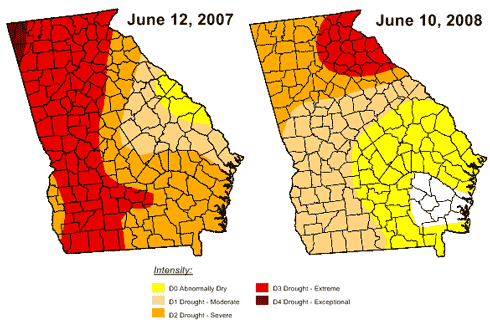
And, indeed the latest drought monitor for Georgia shows an area of extreme drought in the northeast corner of the state enlarging to the west, including portions of Gwinnett county, and virtually all of the Lake Lanier drainage basin. As of Tuesday, 8.9% of Georgia was in extreme drought, compared to 2.3% last week. 61% of the state is classified as being in a moderate drought. However, as the comparison below shows, we’re still better off than we were at this time last year. On June 12, 2007, 47% of Georgia was in extreme drought and 96.1% was in at least a moderate drought.

Drought Conditions Comparison in Georgia, June 2007-2008

The upper level high pressure system that brought the excessive heat and kept rainfall away has moved off the Georgia coast. This has allowed thundershowers to develop, which we’ve seen for the last few nights. Until last evening, they managed to avoid Gwinnett, however around midnight, .57 inches of rain fell at my house—the first significant rain I’ve recorded since May 23rd. The hit or miss nature of these storms is evident in the rainfall totals for yesterday. Atlanta received only .03 inches, Athens only .05 inches and Cartersville .08. However Gainesville recorded .54 inches, Charlie Brown airport .59, and Peachtree DeKalb appeared to have led the metro in rain with .74 inches of precipitation.

Nature responded appropriately, and the view from my window is much greener than it was at this time yesterday. However, the dry soil will quickly absorb all the water. Fortunately, more storms are predicted through the weekend. What we really need is some of the water that has inundated the rivers in Indiana, Illinois and Iowa, which has caused hundred-year-old records to fall.

Sphere: Related Content

Share