Get Forecast For:
Lawrenceville Weather

Dennis Hits Metro Atlanta Hard
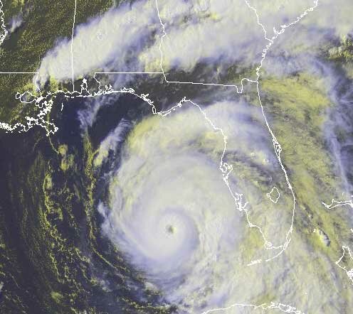
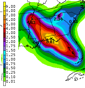
Monday, July 11th, 2005

While Hurricane Dennis managed to slow down a bit before making landfall, its effects were widespread. In addition to the expected coastal damage near where the storm hit the gulf, here are some rainfall amounts from the southeast for Dennis, through 1 PM on Monday:

Austell GA – 9.57 inches
Peachtree City GA – 7.94 inches
Atlanta Hartsfield Jackson Airport – 6.72 inches
Tallahassee FL – 6.64 inches
Fort Myers FL – 4.54 inches
Meridian MS – 3.18 inches

It’s amazing that Georgia has apparently received more rain from Dennis than other locations, particularly in Alabama and Florida, however, that’s the best information that I can find. Mobile Alabama is reporting 10.33 inches through today, and Pensacola reports 4.76 inches of rain for the month. And, that’s through two tropical events.

Atlanta’s monthly rainfall to date is 13 inches, a new record that eclipses that of July, 1994, when tropical storm Alberto stalled in Georgia. Here in Lawrenceville, we’ve had 1.95 inches of rain from Dennis and a total of 6.8 inches for the month — a reflection of the fact that the worst of Dennis occurred on the south and west sides of the metro area. For the year, Atlanta is reporting 33.2 inches of rain, compared to 29.8 inches in Lawrenceville.

Of course, Dennis isn’t finished yet; there is still more rain to come in Indiana and Illinois, where an additional 6 inches of rain is predicted over the next 48 hours.

Meanwhile, Tropical Depression Five continues its westward march. It’s not yet an official tropical storm, with winds at 35 MPH, but all expectations are that it will turn into a named storm by this time tomorrow.

Sphere: Related Content

Share

The Hits Keep On Coming – New Storm in the Atlantic

Monday, July 11th, 2005

As Dennis makes his way up the Mississippi Valley, he’s been downgraded to a tropical depression with maximum winds of 35 MPH. Does that give us a breather from tropical storms for a few days? Probably not, as the Hurricane Center has now officially recognized Tropical Depression Five, which is likely to become Tropical Storm Emily by sometime Tuesday.

The storm is moving to the west at about 12 MPH and the current long-range forecast track has it reaching the Dominican Republic by early Saturday morning, and passing over the north side of Cuba later in the weekend.

The forecast is very likely to change over the next few days as the storm gets more organized.

Sphere: Related Content

Share

Hurricane Dennis Makes Landfall

Sunday, July 10th, 2005

Hurricane Dennis made landfall about 20 miles east of Pensacola, Florida about 3:30 PM EST on Sunday. Estimated wind speeds were about 115 MPH. By 6 PM, the storm had crossed into Alabama, with winds still holding at 105 MPH. Overnight the storm is expected to move into Mississippi, and reach the Tennessee border sometime around noon on Monday.

The picture below shows Dennis about 35 minutes prior to landfall.

The storm is expected to dissipate slowly, landing near Vincennes, in southwestern Indiana by 1 PM Wednesday, and staying fairly stationary through Friday afternoon and bringing about 8 inches to that rain-starved area.

In Gwinnett, Dennis has brought less than 1/4 inch of rain so far, with most falling on Saturday evening. The Metro Atlanta area hasn’t been so lucky, with possible tornadoes in Atlanta, Butts County, and, in general, south of I-20. Gwinnett remains on a flood watch through 6 AM Monday. We can also expect to see up to three and a half inches of rain through Tuesday.

Sphere: Related Content

Share

Dennis Expected to Return to Category 3 Strength

Saturday, July 9th, 2005

The latest estimates for Hurricane Dennis is that it will again become a category 3 storm by the time it makes landfall sometime Sunday afternoon.

The satellite image above shows Dennis over the Gulf of Mexico at about 4:45 eastern time on Saturday. At 5 PM, The storm was located 415 miles southeast of Biloxi, Mississippi, moving towards the northwest at 15 MPH, with winds around 105 MPH. Forecast models are converging on landfall somewhere near Mobile, Alabama sometime Sunday afternoon. This is a bit to the east of earlier forecasts.


Middle Georgia is already beginning to feel the effects of Dennis, with rain falling just to our south. The picture to the right shows the Weather Service’s estimated total precipitation between 8 PM Saturday and 8 PM Monday. The forecast for the Atlanta area is for between 1 1/2 and 2 inches of rain, with the worst rain occurring to the south and west.

My guess is that 2 inches might be too conservative. Local forecasters in Peachtree City have the same opinion. Meanwhile, there are three tropical waves in the eastern Atlantic that continue to move west. Based on their position, and on the fact that we’ve had two tropical storms in one week move through the Gulf, if they turn into full-fledged storms, the East coast could be their destination. We should know more later next week.

Sphere: Related Content

Share

Hurricane Dennis Approaches United States

Friday, July 8th, 2005

Hurricane Dennis is preparing to exit Cuba and continue traveling north towards a rendezvous with the Gulf coast sometime Sunday afternoon. He remains a powerful storm, with winds up to 150 MPH, and is expected to strengthen again while over the warm Gulf waters.

Computer models are predicting Dennis will make landfall somewhere near the Alabama-Florida border, and then move northwest through Alabama and Mississippi, before moving towards the northeast. The erratic pattern (think of it as an upside down, tilted L) is due to the presence of a high pressure system over the Southeast that keeps Dennis from moving East. The effects of the high weaken as the storm moves farther North, and eventually lets Dennis follow the path it wants to.

The real question is how far north the storm will have to go before it moves east. Some computer models have the storm moving east at the Alabama Tennessee border, others the Tennessee Kentucky border, and still others along the Ohio River between Kentucky and Indiana.

Exactly how far the high pressure system forces Dennis west, and how far north the storm must go to move east will have a lot of effect on the weather we see in Georgia. Already, the first clouds are forming over southeast Georgia, and we should begin to see the effects of Dennis in metro Atlanta sometime Saturday afternoon. The best guess now is that the worst effects of the storm will be felt in the south and west portions of the metro area, but that the entire region will get some rain. However, the proof of the pudding is in the eating, as they say, and there probably won’t be an exact estimate until sometime tomorrow evening or Sunday morning.

Meanwhile, a low pressure system currently over the western Atlantic could develop into tropical storm Emily sometime late next week. Dennis is already the earliest category 4 hurricane to develop in the Gulf, and the strongest storm to appear so early in the season. It looks like we’re in for a long summer of tropical weather.

Sphere: Related Content

Share