Get Forecast For:
Lawrenceville Weather

Archive for the ‘Forecasts’ Category

More Snow on the Way for Washington…And Maybe Atlanta

Monday, February 8th, 2010

The Washington, DC area is recovering from its second major snowstorm of the season. At Dulles Airport, the 32.4 inches of snow was the highest two-day total ever recorded. 17.8 inches of snow was measured at Reagan National Airport. That was the second highest total recorded at that location, and the fourth highest total snowfall recorded in Washington. (26 inches was the record DC snowfall, in 1922.)

While the Baltimore airport only recorded 24.8 inches of snow, just to the northwest, in Elkridge, they seem to have gotten more snow than anywhere else, with 34.8 inches.

The bad news for the Washington area is that they are again under a winter storm warning, with a prediction of an additional 10 to 20 inches between noon Tuesday and Wednesday evening. In Atlanta, the storm will only be rain, with the possibility of some snow in the Northeast Georgia mountains.

The real threat for Georgia is this weekend. when another in the series of storms comes barreling north. Some models are indicating several inches of snow, with the snowfall possibly extending into middle and south Georgia. There’s not a lot of confidence in the forecast yet, which is why the early forecast for the weekend doesn’t mention it. But, the models are best at the predictable, and this winter has certainly not been that. Keep your eyes on the forecast as it gets closer to Friday.

Sphere: Related Content

Share

Groundhogs Split on Early Spring Chances

Tuesday, February 2nd, 2010

Once again, it’s Groundhog Day, when the marmots emerge from their holes and decide whether spring is near or not. This year, Lilburn’s own Beauregard Lee emerged on a rainy morning and didn’t see his shadow, foretelling an early spring. However, up in Gobbler’s Knob, Pennsylvania, Punxsutawney Phil arose and saw his shadow, calling for six more weeks of winter. Other woodchucks in Long Island and Canada also split on their forecasts.

Of course, the idea of an animal being able to predict the weather might be more valid if we looked at the timing of its emergence, rather than forcing a decision on February 2nd. For example, I saw the first robin of the season over the weekend. The daffodils seem to be running late this year, another sign of a late spring. The weather service also is calling for a late spring, at least in the south (see my previous post), and the outlook for the next two weeks calls for colder than normal weather.

By the way, how do they decide if the groundhog has made an accurate prediction? At least in Pennsylvania, they look at the number of days in the six weeks after groundhog day when the temperature rises above 40 degrees. If it’s more than half, spring arrived early. 40 degrees wouldn’t work here in Atlanta, where the normal high temperature on February 2nd is 54 degrees. By the first of March, it will be up to 60.

January wasn’t very warm. The mean temperature at Hartsfield Airport in Atlanta for the month was 38.5 degrees, which was 4.2 degrees below normal. It was a little cooler here in Lawrenceville, with 37.3 degrees. Athens was slightly warmer with an average 39.7 degrees, 2.5 degrees below normal. January rainfall was 5.38 inches in Atlanta, .35 inches above normal. Athens had more precipitation, with 6.2 inches, or 1.51 inches above normal. Here in Lawrenceville, I recorded 5.06 inches of rain, however that might be a little short of reality, since my rain gauge doesn’t really handle snow very well.

There’s plenty more rain coming later in the week — up to three inches more. I’m getting tired of it, as I’m sure you are as well.

Sphere: Related Content

Share

Looking Ahead to February and Early Spring

Saturday, January 23rd, 2010

We’re now about three fourths of the way through January, and just about two thirds of the way through Winter. December was 2.7 degrees colder then normal (15th coldest on record) and the second wettest on record, with 9.1 inches of rain. So far in January, Atlanta Hartsfield-Jackson airport is 5.4 degrees colder than normal, but with 2.19 inches of precipitation, only 54% of normal. With more rain predicted for Sunday, and again at the end of the week, we could easily get back to normal January precipitation of 5.03 inches. The verdict for the first part of Winter would have to be colder and wetter than normal.

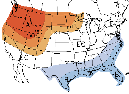
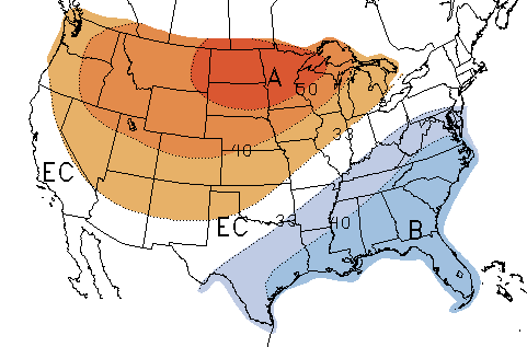
Looking forward to February, and anticipating the groundhogs next month, the early part of spring, it looks like we can expect more of the same. The Climate Prediction Center released its February outlook earlier this week, which is reproduced below:

February Temperature Outlook

February Precipitation Outlook

As is typical for El Nino winters, it’s likely to be colder than normal for much of the Southeast, and warmer than normal for the Northwest. The remainder of the country could be above or below normal. On the precipitation side, most of the southern half of the country will be wetter than normal, with equal chances of dry or wet weather in the north. The greatest chance of excessively wet weather is in southern California and Arizona, not welcome news for an area which has seen extensive flooding this week.
(more…)

Sphere: Related Content

Share

Cold Weather Marks the Start of Winter

Tuesday, November 24th, 2009

We are now just one week away from the start of winter. You may think winter begins on December 20th, the shortest day of the year, but from a weather perspective, winter is the three month period of December, January and February. We’ve enjoyed a relatively mild (albeit wet) fall, with temperatures yet to drop below freezing in the metro Atlanta area, but that will change soon.

The latest predictions from the weather service for winter are pretty much in line with earlier forecasts. Much of the South and Mid-Atlantic states have a 40% chance of colder than normal weather, while the upper Midwest and northern states should be warmer than normal. This is a typical winter pattern in El Nino years like we have this year.

Winter 2009 Temperature Forecast

The precipitation forecast also reflects typical El Nino conditions, with wetter than normal conditions stretching from California along the southern US border to South Carolina, and drier than normal conditions centered over Tennessee and Kentucky. This puts Georgia right in the middle, with the north likely dry, normal in the middle, and wet in the south. Exactly where the dry/wet lines fall could make a big difference in how the weather plays out.

Winter 2009-2010 Precipitation Outlook
(more…)

Sphere: Related Content

Share

Cold Weather This Weekend?

Wednesday, October 14th, 2009

If you’re like me, you are probably sick of all the rain we’ve had over the past month or so. The good news, in addition to less rain today than predicted, is that the weather is going to change beginning on Friday. The bad news is that we are going to get cold.

A front passes through on Friday, blowing out all the rain and tropical air. Behind the front is some of the Canadian air that has been causing some record cold temperatures in the upper Midwest. And, because of a Nor’Easter that will be bringing snow to Pennsylvania and points north, the cold air will be driven further south than it might otherwise have been. The low temperatures forecast for the weekend were in the mid 40s earlier this week. Tonight’s zone forecast calls for temperatures around 40 Saturday and Sunday nights.

But, if you look at the GFS modeling, it’s calling for temperatures around freezing Monday morning in Atlanta, and in the upper 20s for Athens. Will we get there? The record low in Atlanta is 34 for Saturday, 31 for Sunday and 35 for Monday. The normal first freeze in Atlanta is November 10th, about three weeks away. We may not be breaking any records this weekend, but I wouldn’t be surprised if we did end up below 40 degrees. If your furnace has a pilot light, you might want to check it and/or turn it on.

Sphere: Related Content

Share