Get Forecast For:
Lawrenceville Weather

Archive for the ‘Winter 2005-06’ Category

Another Look at Winter – Preparing for 2 Big Outdoor Events
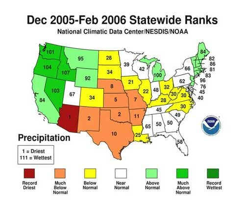
Wednesday, March 15th, 2006

The Weather Service has issued its report on Winter, 2006, with the highlight being the above normal temperatures in January, particularly in the plains states. The temperature rankings for the past winter are shown below.

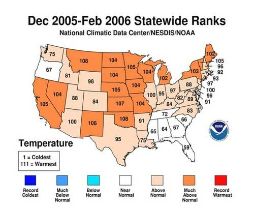
Georgia ranked about in the middle for both temperature and precipitation, with 67th warmest average out of 111 years reported, and the 50th wettest year for the 111 year period.

Meanwhile, the Peachtree City office of the weather service has issued its annual Shareholders Report, with weather highlights in North and Central Georgia for 2005. Highlights include the record number of tornadoes reported during the year, and the effects of the 2005 hurricanes, particularly Katrina. You’ll need Adobe PDF reader to view the report.

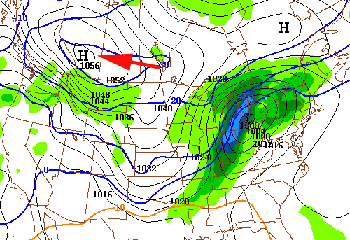
Four days away from the astronomical start of Spring, Atlanta is preparing to host two of its highest profile outdoor events over the next two weeks. Sunday, NASCAR comes to Atlanta Motor Speedway for the Golden Corral 500. Unfortunately it looks like we may be due for a spring storm, with rain 60% likely for most of the day, and highs only in the low 50s.

The race was pushed to a later date several years ago because of persistent bad weather problems, including a major snowstorm in March of 1993 that shut down much of the country.

The other big event is the BellSouth Classic golf tournament, held here in Gwinnett on March 30th through April 2nd. Although we’re two weeks away from that, the GFS model now shows rain on Thursday, moving out on Friday. Last year saw sleet and rain, and a shortened tournament as a result. We’ll see what this year brings.

Sphere: Related Content

Share

Grading Winter

Wednesday, March 1st, 2006

From a meteorological standpoint, winter is over, having ended yesterday. So, how did we do?

Here are the average temperatures, month by month, along with normals:
December: 40.7 46.8 6.1 degrees below normal
January: 48.3 42.7 7.6 degrees above normal
February: 44.3 46.8 2.5 degrees below normal
Winter: 44.4 45.4 1.0 degree below normal

So, we ended up, in the means, about a degree below normal for the winter, although we saw wild swings in the monthly temperatures.

When you take a look back at the early forecasts for winter, it looks like everybody got it right as far as temperatures go, except for the Weather Service, which issued a forecast of equal chances of above or below normal. Kudos go to the Farmer’s Almanac, which predicted the great swings from cold to warm, and then back again.

In the snowfall department, where we really didn’t see anything that caused any major problems at all, Kirk Melhuish got it spot on, with WeatherAmerica and AccuWeather widely missing the mark.

Overall, I would give the best grades to Kirk Melhuish, who was right on both temperature and precipitation.

Speaking of forecasts, I caught Joe Bastardi of Accuweather on Fox News over the weekend, talking about the upcoming hurricane season. While we’re about a month away from the official forecasts, he warned that based on similar patterns in the past, we’re likely to see another active season in 2006, with a probability of hurricanes striking the Atlantic coast, perhaps as far north as the New York area.

Shorter term, we may end up with a more or less normal March. The weather service is calling for equal chances of above or below normal temperatures and precipitation in Georgia for March. Warm weather is expected in Texas, and colder than normal weather is predicted in California. If the Climate Predication Center is right, it will also be rainy in California, and dry in Texas and Florida.

Texas is already feeling the heat, with highs around 90 today. Lawrenceville reached its high so far for the year, with 74.4 degrees. (The normal is 60 degrees). But, it won’t last: after another above normal temperature day tomorrow, it will be cooling down to normal temperatures, although, it’s likely to stay dry for a while, adding to a rainfall deficit for the year.

Sphere: Related Content

Share

Winter May Not Be Over Yet

Sunday, February 19th, 2006

Today’s high temperature of 39 degrees is the coldest high daytime temperature we’ve seen since … last Sunday. However, prior to that, you would have to go back to January 17th, 2005 to see a day when the high temperature was lower. The two cold days mark bookends to a week that also saw the year’s highest temperature to date on Thursday, with a high of 72.8 degrees.

Today’s cold was amplified by the wedge effect, which trapped the morning’s cold temperatures under warmer air aloft. However, we were spared the worst of the weekend’s cold. When I got up this morning, it was 32 in Atlanta, and 21 in Chattanooga. However, 40 miles to the northwest, in Altamont Tennessee, the temperature was a frigid 9 degrees.

After another cold day on President’s day, expect things to warm up, although stay rainy through Thursday. Friday looks to be the nicest day of the week, and then a pattern change brings cold, dry weather in, quite possibly through the end of the month. Both the 6-10 day and 8-14 day forecasts call for colder and dryer than normal temperatures through the period which ends on March 5th. This is especially true for the end of the period, when highs could struggle to make 50 degrees, and overnight lows will be in the mid 20s.

The long-range forecast for March as a whole calls for a slight chance of above normal temperatures, and normal rainfall. It seems like groundhog Beauregard Lee needs to get busy if he wants to salvage his prediction of an early spring.

Sphere: Related Content

Share

Hedging Bets on Weekend Weather

Tuesday, February 14th, 2006

As predicted, the mass of cold, Arctic air is beginning to make its way south. This evening, a surface low is centered over the center of Missouri: as of 8 PM Eastern time, it was 68 degrees in St. Louis, while on the other side of the state, in Kansas City, the temperature has dropped to 32 degrees. It’s already below zero in places like Bemidji, Minnesota, where tomorrow’s high is expected to be a frosty 14 below.

The cold air is going to continue to come towards the Atlanta area. Meanwhile, a high pressure system in the Caribbean is working to block its advance. At the same time, upper air from the southwest continues to bring moist air into the region, along with the possibility of precipitation.

The whole scenario brings a lot of uncertainty to the forecast. One possibility is that we get a wedge effect, where the cold air from the high is overrun by the warm air aloft. This would tend to keep temperatures cooler than they would otherwise. Then, there’s the question of how far south the cold air will make it. The forecast models don’t agree in terms of exactly what will happen.

Expect tomorrow’s highs to be at least ten degrees cooler than today’s almost 73 degree temperatures (only the second time the temperature has been above 70 since November 15th). Saturday, will be likely to be 15 degrees cooler than that.

The real question is what will we see Saturday and Sunday night. If it’s cold enough, we could see sleet or freezing rain – the Weather service has issued a Special Weather Statement calling for the possibility of a wintry mix, but thinks that the most likely area to be affected is north of a Rome – Roswell – Gainesville line.

So, the best advice I can give you now is to not plan on doing a lot outside over the holiday weekend, and to keep an eye on the weather forecasts, which could likely change as the situation plays out.

Sphere: Related Content

Share

Next Round of Canadian Air Unlikely to Hit Atlanta

Tuesday, February 14th, 2006

Atlanta certainly felt more spring-like today, after the cold air that followed last weekend’s storm was finally replaced by warmer southwesterly breezes. However, cold air continues to come in from Canada, with a doozy likely to hit the Plains states later this week.

The map below shows the GFS forecast for 2 AM on Friday. A low pressure system centered over Cleveland, Ohio is spreading between 1/2 and 1 inch of precipitation over Ohio, Indiana, and Michigan, most likely as between 5 and 10 inches of snow. Meanwhile an extremely high pressure dome is located over Alberta, Canada. The 1056 MB of pressure (highlighted with the arrow) is the equivalent of 31.18 inches of mercury — something you don’t see very often, and indicative of very low temperatures. In the plains, temperatures will probably drop well below zero.

Fortunately for those of us in Georgia, we’re not going to see much of a temperature drop. Because the low is going to remain to our north, we’ll see a return to highs in the low 50s and lows around freezing this weekend, followed by seasonable temperatures for the week of President’s Day. The long range forecasts call for normal temperatures and normal to above normal rainfall through the end of the month.

Sphere: Related Content

Share