Get Forecast For:
Lawrenceville Weather

More Rain for North Georgia

Monday, October 12th, 2009

It’s starting to feel like we really are making up for all that missing rainfall from the drought. Today’s rainfall here in Lawrenceville of 2.52 inches brings the total rain for October here to 4.55 inches — more than an inch above what would be expected for the entire month. It’s the wettest October in at least five years.

Atlanta set a new rainfall record for October 12th today, with 2.5 inches. That makes the yearly rainfall for Hartsfield Airport to 50.68 inches. Normal annual rain for Atlanta is 50.2 inches, so we’ve met that milestone with nearly a quarter of the year to go. Athens also set a rainfall record for the day with 3.83 inches. The previous October 12 rainfall record for both cities was set in 1994. Lake Lanier is now at 1070.58 feet above sea level, having gained over half a foot during the day. The lake is now less than half a foot from full pool, although it would take a lake level of 1085 feet before it would be considered flooded. The last time Lanier was at full pool was in September, 2005.

Flooding is occurring, though. Suwanee Creek in Suwanee is at 9.79 feet, with flooding beginning at 8 feet. Big Creek in Alpharetta and the Chattahoochee River in Vinings are also at flood stage. I saw where the Yellow River had escaped its banks into the flood plain in my area.
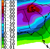
Preciptation Prediction through ThursdayUnfortunately, it looks like we’re up for more rain on Wednesday. After a relatively pleasant day tomorrow, the rain will return, and according to the latest estimate from the Weather Service, shown at right, we could have another two to two and a half inches through Thursday evening, with higher amounts in the northeast Georgia mountains. If that scenario does pan out, expect more possible flooding, since the ground will be even more saturated than when the rain started this morning.

Once all the rain does go away on Friday, we will be in for some cooler weather over the weekend. The cold Canadian air that has brought an early Winter to much of the Plains states is moving east. Right now, overnight temperatures for the weekend are predicted to be in the mid 40s, but I wouldn’t be surprised if they end up a bit lower than that.

Speaking of cold in the west, I’ve got to take note of the fact that in Denver, Colorado, temperatures dropped to a chilly 18 degrees Saturday morning, and didn’t get out of the 20s, forcing the cancellation of the third game of the baseball playoffs. The low temperature was the coldest it’s been so early in the season in Denver. Temperatures also dropped below the freezing mark this morning in Chicago. It was 34 in Dayton, Ohio and 28 in Grand Rapids, Michigan on Sunday morning. Record cold temperatures were felt in Montana, and the cold in Idaho may make it difficult for farmers in Idaho to harvest their potato crop.

It doesn’t look like things are going to get much better in Georgia at least through the end of the month. The 6-10 and 8-14 day forecasts call for continued chances of above normal precipitation, and colder than normal temperatures in the 6-10 day period. Long-range winter forecasts call for a cold and wet winter in the southeast, a topic I’ll try to cover in more detail later in the week.

Sphere: Related Content

Share

Incredible Rainfall Pounds Atlanta

Monday, September 21st, 2009

If you think we had plenty of rain over the last six days, it looks like day seven is the one to beat them all. As of 6:50 this morning, my rain gauge is reporting 5.84 inches of precipitation fell…this morning. The AJC is reporting that Spaghetti Junction is closed because of heavy rain (both I-85 and I-285). In Gwinnett, two feet of water is blocking the intersection of Scenic Highway and Sugarloaf Parkway, and there is additional flooding in downtown Lawrenceville. The weather service is reporting 7 inches of rain in Lilburn, over 3 inches in downtown Atlanta, and 9 inches in southwest Atlanta.

So, that brings the total rainfall for the last week to 12.57 inches. In Atlanta, 3.72 inches of rain fell on Saturday, breaking a record. I’m sure there will be more records set today. Flash flood warnings are in effect until later this morning, with flood warnings until

And if you’re wondering about Lake Lanier, it’s rising rapidly as well. After being fairly stable until the weekend, the runoff and excessive rain has cause the lake’s level to rise by a foot since Sunday morning, and I imagine it will continue to go up. The current level is 1065.81 feet.

Sphere: Related Content

Share

Is the North Georgia Drought Finally Over?

Thursday, May 7th, 2009

Compared to the past few years, the weather this spring in North Georgia has been wet. Virtually the entire state reported above-normal rainfall in April, which followed a wetter than normal March.

Some unofficial reports of rainfall totals in April were over ten inches in South Georgia, while the highest official total was 7.3 inches in Alma, over four inches above normal. Atlanta was 1.56 inches above normal for April, and Athens had 1.12 inches above normal precipitation.

May has gotten off to a wet start as well. As of May 6th, Atlanta had recorded 2.05 inches of rain, which is 1.31 inches above normal for the first week in May. With this morning’s storms and chances of more wet weather still ahead through the weekend, we are close to reaching the 2.8 inches of precipitation recorded for all of May, 2008, and will have more May rain than since at least 2004. Normal May rainfall in Atlanta is 3.95 inches for the entire month.

Lake Lanier continues to fill as well. The lake level is at 1064.95 feet at Buford Dam, 7 inches above where it was when the current rains started a week ago, and just six feet below full pool.

The latest drought outlook from the Climate Prediction Center says,

Several inches of precipitation are forecast in the short-term for the last vestiges of the once expansive drought that covered the interior Southeast. Given the expected heavy precipitation through the forthcoming weekend, and nothing indicating enhanced probabilities for significantly below-normal rainfall through the end of July, it seems likely that we will finally be able to close the books on this protracted and at one time serious, large-scale drought that has been affecting the Southeast for the last 3 years.

And, State Climatologist David Stooksbury reported earlier this week that conditions on Lakes Lanier and Hartwell have improved to mild drought from moderate drought because of the increasing lake levels. The rest of the state is drought free. He reports above normal soil moisture for most of the state, and normal to above normal stream flows. He says,

May is typically one of the drier months in Georgia. Additionally, with high temperatures routinely in the 80s and plant water use very high, moisture loss is accelerated. We normally expect the soils to start to dry out this month.

As we progress through the summer into the middle of fall, moisture loss from the soil – due to evaporation and plant use – is normally greater than rainfall. With normal weather over the next several months, Georgians can expect to see a drying of the soils. However, this is normal and does not mean that Georgia is heading back into a drought.

Sphere: Related Content

Share

A Possible Return to Wintry Weather

Thursday, April 2nd, 2009

Two years ago, on April 7th, Atlanta temperatures dropped to 30 degrees in the city and 28 degrees here in Lawrenceville in an event known as the Easter Freeze. We might just be in for a repeat this year, to the day.

After today’s rain moves out overnight, we’ll see some sunny weather this weekend, until another cold front passes Sunday night or Monday morning. Behind that front will be some cold Canadian air which could drop temperatures into the 20s Tuesday morning, April 7th. Of course, a lot could change by Tuesday, but I would still hold off on planting annuals for another week or two.

Atlanta ended up with 7.13 inches of rain in March, not enough to make the top ten in terms of rainfall, but almost two inches above normal. While Tuesday’s AJC front page headline shouted “Area’s historic drought is now over,” WXIA’s story had the more telling headline, “Climate Drought Over, But Political Drought Still On.” The bottom line is that level 4 watering restrictions in much of the metro Atlanta area won’t be lifted until we see four months of normal or above normal rainfall, with March counting as the first month. Keep your eye on the water level in Lake Lanier, which has risen almost two feet since the late March rains began, and now stands at 1060.94 feet, still 10 feet below normal summer pool. Increasing that level becomes more difficult, first because since the lake doesn’t have vertical sides like a swimming pool, each additional inch of rise requires more water, and second because as temperatures warm and trees leaf out, there will be less runoff into the lake.

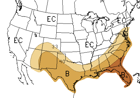
We’ve already gotten a good start on the proverbial April showers, though. I’ve recorded 1.22 inches of rain through this morning for the month, and normal April rain is 3.62 inches. The Climate Prediction Center has revised their precipitation outlook for April as well. Here is what they though was going to happen in their initial outlook back on March 19th:

March 19th Rainfall Prediction for April

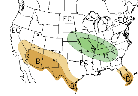
As you can see, the outlook was for continued dry weather in the southeast. Now take a look at the revised outlook from March 31st:

March 31st Precipitation Outlook for April 2009

It’s quite a change. The latest 6-10 and 8-114 day outlooks are also calling for a greater chance of above-normal rainfall through the middle of the month. The latest national drought outlook for April-May shows no drought in most of Georgia, and improving conditions in the the remaining eastern part of the state.

Sphere: Related Content

Share

March Rains Largely End North Georgia’s Drought

Monday, March 30th, 2009

Widespread March rainfall has caused all but a few North Georgia counties to become drought free. According to information from Georgia Climatologist David Stooksbury, the only counties still considered to be in moderate drought are Union, Towns, Rabun, Lumpkin, White, Habersham, Hall and Stephens. A few northwest Georgia counties are drought free, while the remainder, including Gwinnett, are classified as abnormally dry, mostly due to the long-term rain deficit we’ve experienced for the past four years.

Atlanta has recorded 7.12 inches of rain in March, over two inches more than normal. For the year, the deficit is 1.09 inches. With 7.03 inches of March rain in Athens, the Classic City is only .39 inches below normal for the year. With an additional inch or so expected Tuesday through Thursday, both cities could be back to normal rainfall by the end of the week.

While the plentiful precipitation seems to have encouraged Atlanta area flora to show their spring colors more strongly than in recent years, the hidden subtext of the drought picture, which I assume will be reflected in Thursday’s drought monitor, is that the counties that make up Lake Lanier’s drainage basin, including Hall and Habersham, are still in a moderate drought. Last week’s rainfall raised Lanier’s level by over a foot, but the lake is still ten feet below full summer pool.

The current climate pattern of a weak La Nina transitioning to neutral is responsible for much of the changes to a wetter spring. According to Stooksbury:

Currently the climate pattern is a weak La Niña pattern tending toward a neutral pattern. A typical weak La Niña spring brings wet weather across the northern piedmont into the mountains, just like north Georgia experienced in March.

Moisture conditions are in good shape across most of the state’s northern half, but the typical moisture recharge period will be ending soon. By the middle of April, plants are in full spring growth and using tremendous amounts of water.

By the middle of April we can expect the soils to begin to dry because of increased plant water use. Additionally, by the middle of April, temperatures are routinely in the 70s to low 80s. This means that evaporation will increase. This late spring and summer drying is normal.

The outlook is for a few more weeks of recharge followed by the normal drying of the soils due to plant water use and evaporation. May is usually a dry month. Little recharge is expected from May through October, but this is typical for Georgia.

The big unknown is what the tropics will bring Georgia this summer and winter. Much of the state’s late summer and fall rain comes from tropical disturbances. Without moisture from the tropics, August through October can be very dry. At this time there are no clear indications of how much rainfall the summer will bring.

Sphere: Related Content

Share