Get Forecast For:
Lawrenceville Weather

August 2006 Ends Wet, Thanks to Ernesto

Friday, September 1st, 2006

August ended up having two distinct weather patterns. For the first ten days of the month, Lawrenceville had high temperatures above 90 degrees on all but one day, and had just over an inch of rain, slightly below normal. For the rest of the month, temperatures broke 90 degrees on only 3 days, and we had over 4.5 inches of rain, more than what would be expected for the entire month.

Here are the temperature and rainfall statistics for August, 2006:

Atlanta Hartsfield had a mean temperature of 81.0 degrees, 2.1 degrees above the normal 78.9 degrees. There was 8.74 inches of rain recorded, a whopping 238% above the normal 3.67 inches of precipitation.

In Athens, temperatures averaged out at 80.7 degrees, 2.3 degrees above normal (and one day above 100 degrees). Athens received 5.77 inches of rain, or 153% of the normal 3.78 inches of precip.

Gainesville had an average temperature 3.6 degrees above normal, with 81.1 degrees. They had less rainfall than expected, with 3.39 inches recorded, compared to a normal of 3.97 inches.

And, here in Lawrenceville, I recorded a mean temperature of 78.5 degrees, and a total of 5.63 inches of rain.

Tropical Storm Ernesto has now made landfall in South Carolina, and is expected to bring plenty of rain to the Delmarva area, and into western Pennsylvania later this weekend. All in all, the storm turned out to be slightly less than what it could have been, but coming on the heels of the 1 year anniversary of Hurricane Katrina, I guess a certain amount of hype could be expected. It reminds me of what happened after the infamous January 1982 Snow Jam, when six inches of unexpected snow fell during an afternoon rush hour, causing six hour commutes. The following year, vowing ‘never again’, city leaders told everyone to go home at lunch time as a few flakes fell, and, of course, the snow never happened.

Many areas in Georgia saw a few inches of rain as a result of Ernesto. Almost half Atlanta Hartsfield’s rain for the month came yesterday, with 4.3 inches recorded — more than Charleston, SC, which reported 2.61 inches of rainfall. The huge Atlanta rainfall broke a record dating back to 1918. Obviously, a storm cell sat over the airport yesterday.

Conditions should be improving over the next few days as Ernesto works his way north. The Weather Service is predicting cooler than normal temperatures for the first half of September, and above normal precipitation for the month. Look for the next major chance of rain to occur late next week, when, of all things, the remnants of Hurricane John, about to make landfall on the west coast, drift into our area.

Sphere: Related Content

Share

Ernesto Over Florida

Wednesday, August 30th, 2006

This morning, Tropical Storm Ernesto is over southern Florida, with winds reported at 45 MPH. Fortunately for Floridians, the storm didn’t pick up much steam as it traveled between Cuba and the US. However, the storm has an eye, which you can see in the picture below, taken shortly after 8:00 on Wednesday.

By early Thursday, the storm will have moved off the Florida coast and will again be over open water. The Hurricane Center isn’t predicting that he will become a hurricane again before making landfall again in South Carolina late Thursday night, but has left open the possibility with a hurricane watch along the coast. Once the storm makes it’s second landfall, it will travel through North Carolina and Virginia as a tropical storm, and then dissipate somewhere near Erie, Pennsylvania on Sunday.

Here in Atlanta, the main effect of Ernesto will be to stall out a frontal system over our area for the next 36 hours. Our area has been sandwiched between the low pressure system to the north, and Ernesto to the south, keeping dewpoints and the chance of precipitation high. We’ll see the same type of weather through the start of the weekend. Over the weekend, it will be cooler and a little less humid, although there is a chance of a thunderstorm each day.

Sphere: Related Content

Share

Ernesto Prepares For a Direct Hit on Florida

Monday, August 28th, 2006

The latest forecasts for Ernesto show the storm returning to hurricane status after it spends today moving over Cuba. By early Wednesday morning, Ernesto will pass over the Florida Keys, and will spend the day on Wednesday raining on Florida, before emerging into the Atlantic early Thursday. By the end of the week, the hurricane will be near the North Carolina-Virginia Border.

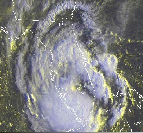
This is going to bring a lot of rain along the Eastern seaboard, as you can see from the five day precipitation forecast shown at the right. About 8 inches of rain is expected in the Miami area, and up to ten inches in the outer banks of North Carolina.

The storm is being kept from moving further west by an upper level trough and its associated surface front currently stretching from Illinois to New Jersey. That low pressure system is slowly moving south, and will likely give us rain on Tuesday and Wednesday, before it is finally absorbed by Ernesto.

The trough is not only increasing the chances that Ernesto will cause minimal havoc to west Florida, Georgia, and South Carolina. It’s also likely to be the system that breaks the back of our summer heat. After everything passes through on Thursday, temperatures will moderate to the upper 70s to low 80s for Labor Day weekend, with lows in the low 60s. With dewpoints in the 50s on Labor Day, the humidity will be gone as well.

Typically Atlanta gets a front like this that brings some relief from summer weather in mid-August, only to see a final blast of summer before things cool down permanently in mid-September. We didn’t see that this year; instead it looks like we are going to see fall-like weather enter our area to stay before Labor Day.

Sphere: Related Content

Share

Ernesto Could Hit Florida As a Major Hurricane

Sunday, August 27th, 2006

Hurricane Ernesto continues to gain strength, and with winds estimated at greater than 75 MPH early this morning was upgraded to Category 1 status. Expected to pass between Haiti and Jamaica overnight tonight, and across Cuba on Monday, the hurricane is likely to gain intensity as it crosses the Gulf of Mexico to the west of the Florida Keys.

There has also been a significant change in the storm’s expected path. For the past 48 hours, models have been moving the expected landfall point further east. As of this morning, the National Hurricane Center expects the storm to cross Florida somewhere north of Tampa Bay on Thursday, and emerge near Jacksonville on Friday.

As you can see from the map above, there is still some disagreement among the many forecast models on the exact path and landfall position. However, most of them are ‘seeing’ a high pressure system currently over the Rocky Mountains moving southeast during the week and ultimately forcing Ernesto to recurve over Florida.

How will this affect the weather in Georgia? Had the storm continued on the previously forecast path, we might have seen a lot of rain, as the center of the storm could have passed through Alabama and Georgia. The current path threatens the Georgia coast, but reduces the rain threat in North Georgia, since the worst effects of a hurricane are on its eastern side.

This week, we’re going to see pleasant weather during the first half of the week, and then a good chance of rain as the front approaches from the west on Wednesday and Thursday. What we’ll get over the first part of the Labor Day weekend depends on the exact track of Hurricane Ernesto, but the outlook on the holiday itself calls for cooler weather than we’ve seen, with highs only in the low 80s.

Sphere: Related Content

Share

Ernesto To Threaten Gulf Region

Friday, August 25th, 2006

Almost one year after Hurricane Katrina caused so much damage to the New Orleans area, newly-named Tropical Storm Ernesto is set to enter the Gulf Coast area over the next few days. The storm’s path indicates it will pass over Jamaica on Sunday as a tropical storm, then intensify into a hurricane by the beginning of the week.

It’s still too early to estimate exactly where Ernesto will end up, but assuming that he makes it past the tip of Yucatan, next week could be America’s first real test of hurricane responsiveness this year.

Sphere: Related Content

Share