Get Forecast For:
Lawrenceville Weather

Atlanta Gets Second Taste of Snow

Saturday, February 13th, 2010

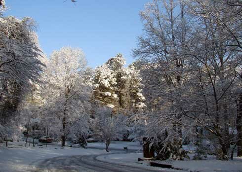
The Atlanta area got its second snowfall of the season on Friday, as a winter storm moved across the south. The snow began falling around 1:30 PM with wet, heavy flakes that immediately began sticking to the grass, and eventually the roads. Overnight, the weather cleared and the temperatures dropped, providing residents with a beautiful winter morning typically seen on Christmas cards.
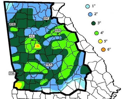
Snowfall totals in Georgia from the February 12th storm include 3.6 inches in Atlanta and 4.5 inches in Athens. The heaviest snow appeared to be in Henry County, with 6 inches. Other reports around Georgia include Savannah with .9 inches and Metter with 2 inches. Charleston, SC reported 3.3 inches of snow.
This morning, there is snow on the ground in 49 of the 50 states, which may be an all time record, according to the AP. People in Hawaii are scouring the tops of mountains there, looking for traces of snow in the only state not reporting snow on the ground. Here is a map of snow cover as of Friday Saturday afternoon:

With temperatures expected to reach over 40 degrees this afternoon, much of Atlanta’s winter wonderland will melt. But, there’s a possibility of yet more snow on Sunday or Monday. Enjoy the snow while you can.

Sphere: Related Content

  • Share/Bookmark

DC to get Record Snow This Weekend

Saturday, February 6th, 2010

The weather news this weekend is the predicted record-breaking snow in the Baltimore-Washington area. Atlantans are famous for stocking up on bread and toilet paper whenever the white stuff is predicted to fall, but apparently it’s just as bad in DC, except there they are stocking up on bottled water and liquor.

And then there’s this forecast:

A three foot snowstorm is never a lot of fun – especially when last week’s snow is still on the ground. In 1077, I was living in Meadville, Pennsylvania, which is about 90 miles north of Pittsburgh. We got three feet of snow over a two day period, and I had to walk to work in it (or maybe it was wade to work in it). At the time, I was working as a newscaster on the local radio station. ABC radio news called from New York for a snow report. I think that was the only time I ever made an appearance on a national radio news broadcast.

As of 11 PM, it looks like snowfall between 4 and 18 inches has been reported in the Virginia/DC/Maryland/West Virginia area. The show is expected to last through Saturday night.

Sphere: Related Content

  • Share/Bookmark

Record Cold Hangs On

Sunday, January 10th, 2010

It seems like the cold weather just doesn’t want to go away. With the turn of the new year, the weather pattern changed as well, with high pressure systems over the Plains states and off of New England forming an opening between to allow unusually cold air to sweep southward. Mix that with a non-existent southern jet stream, and the cold moves across the eastern seaboard.

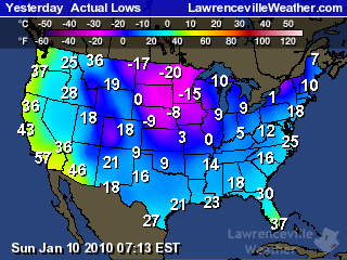
The map to the right shows the low temperatures across the country on January 9th. For the first ten days of the month, the mean temperature I’ve recorded here is 27.5 degrees–below the normal low for this time of year, which should be 33. The mean temperature for the same period in 2009 was 49.9.
We haven’t seen record cold, though. The lowest temperature I recorded here through the period was 13.5, last seen on January 16, 2009. The 13.9 chiller ties the record for the coldest temperature my thermometer has measured over the last eight years. Official records from Atlanta Hartsfield put the low records for the first ten days of the month in the single digits.

The good news (if there is any) is that with the extremely cold temperatures, we didn’t get a lot of precipitation. The snow on Thursday amounted to less than half an inch in my yard. Panic, school closings and shortages of bread and milk all occurred, but that’s par for Atlanta. I don’t know how much liquid precipitation fell on Thursday–snow and my rain gauge don’t play well together–but it was the longest stretch without rain since the latter part of November.

Elsewhere, heavy snow and cold led to snowplows being thwarted in the Midwest, and even snow flurries reported in Miami yesterday by the National Weather Service:

BY THE WAY…COUPLE TRAINED WEATHER SPOTTERS REPORTED A FEW SNOW FLURRIES IN THE WEST BOYTON BEACH… AND A FEW SMALL ICE PELLETS IN PALM BEACH THIS EVENING WITH THE RAIN SHOWERS. ANOTHER TRAINED STORM SPOTTER IN BROWARD COUNTY REPORTED A FEW FLURRIES IN OAKLAND PARK WITH THE LIGHT RAIN SHOWERS EARLY THIS EVENING…ALONG WITH A TRAINED SPOTTER IN MIAMI-DADE COUNTY REPORTING A FEW FLURRIES WITH SOME SLEET JUST SOUTHEAST OF TOWN AND COUNTY MALL.

It has been interesting to watch the forecasts over the past few days. Earlier last week, forecasts were predicting 50 degree temperatures today. It got up to 34. By Thursday, it’s supposed to be in the upper 50s. Want to bet it gets there? The models used to forecast upcoming weather assume that cold spells in the southeast are somewhat short-lived, so they try to get back to normal temperatures fairly quickly. This bias is what causes predictions of an earlier than actual warmup.

It will warm up. The North American Oscillation, which is a good indicator of temperatures on the east coast is trending positive, and the 6-10 and 8-14 day forecasts call for warmer than normal temperatures in the southeast. But, I wouldn’t be surprised to see another one or two rounds of colder than normal temperatures before winter ends in March.

And of course, when it finally does warm up by next weekend, what are we going to get? Significant rainfall and a chance of flooding. But that’s a topic for another post. And for those that asked I will try to post more. Blame the holidays and a busy schedule.

Sphere: Related Content

  • Share/Bookmark

September and October Second Wettest Ever for Atlanta

Sunday, November 1st, 2009

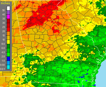
With October now in the history books, it’s pretty clear that north Georgia had its second very wet month in a row. Athens reported 9.14 inches of precipitation, with only 1937 being wetter, with 11.23 inches. In Atlanta, Hartsfield-Jackson airport recorded 8.71 inches, with only 1995′s Hurricane Opal bring more October rain than last month, with 11.04 inches.

Here in Lawrenceville, I recorded 7.47 inches, in Gainesville, they had 11.2 inches or rain, with Macon and Columbus still top-ten wet, with 6.37 and 6.39 inches of precipitation, respectively. Even more of an eye-opener is the two month totals for September and October, shown graphically below:

September-October, 2009 Georgia rainfall

The two month period saw 17.65 inches of rain fall in Atlanta, second only to 1888, when 18.25 inches fell. Both Athens and Macon had their wettest September and October ever, with 19 inches in Athens and 17.05 inches of rain in Macon. Columbus had it’s third wettest September-October with 11.69 inches, and in Lawrenceville, which received some of the heaviest rainfall in the September flooding, I recorded 23.3 inches for the period.

Usually heavy late-summer rain is brought about via tropical storms or hurricanes affecting Georgia, but not this year. (This season has had the least tropical activity since 1997, with one month to go before it ends). And of course the one benefit to all the rain is that it returned Lake Lanier to full pool, marking a recovery from the drought.

October also proved to be cooler than normal for North Georgia. Atlanta’s average temperature of 61 degrees was 1.9 degrees cooler than normal, while in Athens, the average of 60.7 degrees was 1.1 degree less than normal. Here in Lawrenceville, I recorded an average of 59 degrees, cooler still.

It looks like we’ll have a chance to dry out during the first two weeks of November, though, and perhaps see temperatures a bit warmer than normal for mid-Autumn. The short term forecast is for dry weather, while the 6-10 and 8-14 day forecasts are also calling for warm and dry. For the month as a whole, the Climate Prediction center calls for a 33% chance of drier than normal conditions, and equal chances of above or below normal temperatures.

Enjoy November, because the winter forecasts from December through February I’ve seen are almost unanimous in their call for a cold, wet winter.

Sphere: Related Content

  • Share/Bookmark

More Rain for North Georgia

Monday, October 12th, 2009

It’s starting to feel like we really are making up for all that missing rainfall from the drought. Today’s rainfall here in Lawrenceville of 2.52 inches brings the total rain for October here to 4.55 inches — more than an inch above what would be expected for the entire month. It’s the wettest October in at least five years.

Atlanta set a new rainfall record for October 12th today, with 2.5 inches. That makes the yearly rainfall for Hartsfield Airport to 50.68 inches. Normal annual rain for Atlanta is 50.2 inches, so we’ve met that milestone with nearly a quarter of the year to go. Athens also set a rainfall record for the day with 3.83 inches. The previous October 12 rainfall record for both cities was set in 1994. Lake Lanier is now at 1070.58 feet above sea level, having gained over half a foot during the day. The lake is now less than half a foot from full pool, although it would take a lake level of 1085 feet before it would be considered flooded. The last time Lanier was at full pool was in September, 2005.

Flooding is occurring, though. Suwanee Creek in Suwanee is at 9.79 feet, with flooding beginning at 8 feet. Big Creek in Alpharetta and the Chattahoochee River in Vinings are also at flood stage. I saw where the Yellow River had escaped its banks into the flood plain in my area.

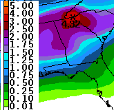
Preciptation Prediction through ThursdayUnfortunately, it looks like we’re up for more rain on Wednesday. After a relatively pleasant day tomorrow, the rain will return, and according to the latest estimate from the Weather Service, shown at right, we could have another two to two and a half inches through Thursday evening, with higher amounts in the northeast Georgia mountains. If that scenario does pan out, expect more possible flooding, since the ground will be even more saturated than when the rain started this morning.

Once all the rain does go away on Friday, we will be in for some cooler weather over the weekend. The cold Canadian air that has brought an early Winter to much of the Plains states is moving east. Right now, overnight temperatures for the weekend are predicted to be in the mid 40s, but I wouldn’t be surprised if they end up a bit lower than that.

Speaking of cold in the west, I’ve got to take note of the fact that in Denver, Colorado, temperatures dropped to a chilly 18 degrees Saturday morning, and didn’t get out of the 20s, forcing the cancellation of the third game of the baseball playoffs. The low temperature was the coldest it’s been so early in the season in Denver. Temperatures also dropped below the freezing mark this morning in Chicago. It was 34 in Dayton, Ohio and 28 in Grand Rapids, Michigan on Sunday morning. Record cold temperatures were felt in Montana, and the cold in Idaho may make it difficult for farmers in Idaho to harvest their potato crop.

It doesn’t look like things are going to get much better in Georgia at least through the end of the month. The 6-10 and 8-14 day forecasts call for continued chances of above normal precipitation, and colder than normal temperatures in the 6-10 day period. Long-range winter forecasts call for a cold and wet winter in the southeast, a topic I’ll try to cover in more detail later in the week.

Sphere: Related Content

  • Share/Bookmark