Get Forecast For:
Lawrenceville Weather

2009-10 Winter Weather Forecasts: Cold and Wet

Friday, October 16th, 2009

The winter weather forecasts for 2009-2010 have arrived, and there appears to be a lot of agreement between the three I have reviewed so far. This winter (December through February) is likely to be affected by an El Nino episode that alters the jetstream patterns, especially the southern branch, bringing a colder, wetter winter for most of the southeast and mid-Atlantic States.

The Weather Service predicts a better than 40% chance of cooler than normal weather in Virginia, North Carolina and Georgia, and the southern half of Alabama, Mississippi and Louisiana. Kentucky, Tennessee, and the northern half of the deep South are also likely to be cooler than normal. Much warmer than normal conditions are expected in the northern Great Plains and Rocky Mountain states, with warmer than normal conditions in Wisconsin, and stretching south into Nebraska and New Mexico.
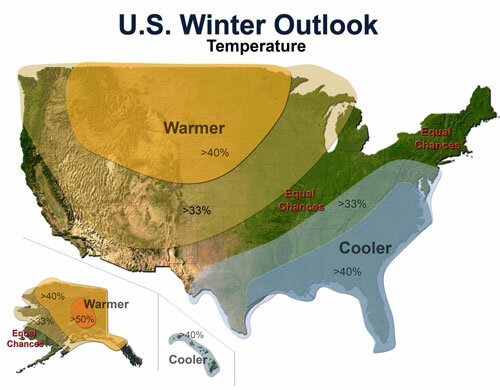
2009-10 Winter Outlook

The Accuweather winter forecast restricts the much below normal temperatures to Tennessee, Alabama and Mississippi, along with northern Georgia, western Virginia, and the western Carolinas. They predict above or below normal temperatures for the entire country, with no area set for normal temperatures.

The Weather Service precipitation outlook calls for a much greater chance of rain in Florida south of Orlando and in south Texas, with above normal precipitation in southern Georgia, most of Texas, and in California. Drier than normal weather is expected in the mid-Mississippi valley and in the northwest. The rest of the country has equal chances of above or below normal precipitation.

The Accuweather forecast brings the above-normal precipitation chances further north, covering the Carolinas, Georgia, Alabama, Mississippi, and west to New Mexico, and north into California. Dry conditions are expected in the midwest and upper Northwest.
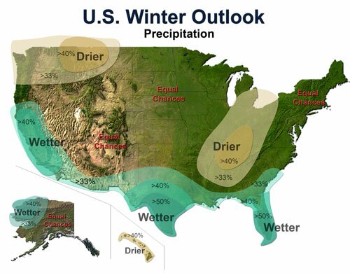
Winter 200-2010 Precipitation Forecast

All of this means that the metro Atlanta area has a better than normal chance of seeing snow or ice this winter, especially when compared to the last few years. And that is what WSB Radio meteorologist Kirk Melhuish says in his preliminary winter outlook. Melhuish predicts normal temperatures and above normal precipitation in the Atlanta area, with an above normal chance of ice and snow. He will issue a final outlook around Thanksgiving.

Sphere: Related Content

Share

July Was Cooler Than Normal for Much of the Country

Wednesday, August 5th, 2009

July ended up being cooler than normal for the northern and eastern parts of the US, in some cases setting records or near records for the cold weather.

In Atlanta, the average temperature of 78.1 was 1.9 degrees cooler than normal, and cooler than it was in June, when the average temperature was 79.8 degrees, or three degrees above normal. July’s colder than normal temperatures were helped out by low humidity and much colder than normal lows from the 18th through the 21st, with two record low temperatures set during that time.

Atlanta was not the only location to have a colder than normal July. In New York City, the average temperature of 72.7 was 3.8 degrees below normal, continuing a trend that began earlier in the spring. With a high temperature of 84 degrees in June and 86 in July, this was the second time New York weather failed to reach 90 degrees in June or July. The other time was in 1996.

Other cities with colder than normal temperatures in July include Chicago, whose average temperature of 71.0 degrees was 4.5 degrees colder than normal; Cincinnati, with a 70.9, 5.9 degrees colder than normal and Kansas City, Missouri, with an average of 75.4, 3.1 degrees colder than normal.

The heat did show up in much of Texas. In Houston, the average temperature of 86.7 was 3.1 degrees warmer then normal, and in Austin, the average of 89 was 4.8 degrees warmer than normal.

Rainfall in Georgia seemed to be concentrated in the western part of the state. Atlanta ended up with 5.02 inches of July rain, just slightly less than normal. However in Lawrenceville, I only received 3.48 inches, most of it on the last few days of the month. In Athens, only 1.33 inches of precipitation fell, which was 30% of normal July rainfall.
(more…)

Sphere: Related Content

Share

March Rains Largely End North Georgia’s Drought

Monday, March 30th, 2009

Widespread March rainfall has caused all but a few North Georgia counties to become drought free. According to information from Georgia Climatologist David Stooksbury, the only counties still considered to be in moderate drought are Union, Towns, Rabun, Lumpkin, White, Habersham, Hall and Stephens. A few northwest Georgia counties are drought free, while the remainder, including Gwinnett, are classified as abnormally dry, mostly due to the long-term rain deficit we’ve experienced for the past four years.

Atlanta has recorded 7.12 inches of rain in March, over two inches more than normal. For the year, the deficit is 1.09 inches. With 7.03 inches of March rain in Athens, the Classic City is only .39 inches below normal for the year. With an additional inch or so expected Tuesday through Thursday, both cities could be back to normal rainfall by the end of the week.

While the plentiful precipitation seems to have encouraged Atlanta area flora to show their spring colors more strongly than in recent years, the hidden subtext of the drought picture, which I assume will be reflected in Thursday’s drought monitor, is that the counties that make up Lake Lanier’s drainage basin, including Hall and Habersham, are still in a moderate drought. Last week’s rainfall raised Lanier’s level by over a foot, but the lake is still ten feet below full summer pool.

The current climate pattern of a weak La Nina transitioning to neutral is responsible for much of the changes to a wetter spring. According to Stooksbury:

Currently the climate pattern is a weak La Niña pattern tending toward a neutral pattern. A typical weak La Niña spring brings wet weather across the northern piedmont into the mountains, just like north Georgia experienced in March.

Moisture conditions are in good shape across most of the state’s northern half, but the typical moisture recharge period will be ending soon. By the middle of April, plants are in full spring growth and using tremendous amounts of water.

By the middle of April we can expect the soils to begin to dry because of increased plant water use. Additionally, by the middle of April, temperatures are routinely in the 70s to low 80s. This means that evaporation will increase. This late spring and summer drying is normal.

The outlook is for a few more weeks of recharge followed by the normal drying of the soils due to plant water use and evaporation. May is usually a dry month. Little recharge is expected from May through October, but this is typical for Georgia.

The big unknown is what the tropics will bring Georgia this summer and winter. Much of the state’s late summer and fall rain comes from tropical disturbances. Without moisture from the tropics, August through October can be very dry. At this time there are no clear indications of how much rainfall the summer will bring.

Sphere: Related Content

Share

NOAA Issues Spring Weather Outlook

Saturday, March 21st, 2009

The Weather Service has issued its outlook for spring weather – April, May and June – although some would argue that especially in the South, spring runs from March through May. In any case, the next three months don’t show a trend one way or another for most of the Southeast US.

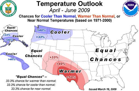
Spring 2009 Temperatures

East of the Mississippi River, there are equal chances of above or below normal temperatures. There’s a good chance of warmer than normal weather in the southwest, especially in Texas and New Mexico. The Northwest is expected to be cooler than normal, especially in Washington. Hawaii and parts of Alaska should be cooler than normal as well.

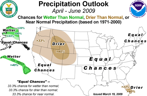
Spring 2009 precipitation outlook

Likely wetter than normal weather is expected in Alaska and Hawaii, while there should be less than normal precipitation in south Florida, the Rocky Mountains and the Pacific Northwest. The rest of the country has equal chances of above or below normal rainfall.

Because of all the snow this winter, there is a greater than normal chance of flooding in the upper Midwest, especially along the Red River Valley. There’s also a better than normal chance of flooding along the western Great Lakes region of Michigan and northern Illinois, Indiana and Ohio.

The overall weather is considered to be in an El Nino pattern, the warm cycle of Pacific Ocean sea surface temperatures. The El Nino pattern is expected to diminish to a neutral pattern later this spring, and in any case, its effects are less pronounced in the spring and summer months. In the southeast, where El Nino tends to bring drier than normal weather, you can see this in the outlook for April, which is likely to be drier then normal, compared to the April-June outlook, which could see above, normal or below normal rainfall.

In the short term, north Georgia could see a rainy stretch starting midweek, followed by a chance of freezing temperatures at night following more rain and the passage of a cold front next weekend. Until then, however, we’ll have pleasant late March weather, so get out and enjoy it.

Sphere: Related Content

Share

Warm Weekend Weather Will Have Georgians Thinking Spring

Tuesday, March 3rd, 2009

I was winding my way through the big box home center today picking up a few things, when I noticed the racks of petunias, geraniums and even tomatoes in gallon containers waiting to be sold to unsuspecting consumers.

We’re about to see a real warm up starting on Thursday. By the weekend, we’re likely to see high temperatures in the mid-70s, with lows around 50, which will continue through the middle of next week. Undoubtedly, these tender annuals will be picked up by eager gardeners ready to start Spring. These same folks are likely to be disappointed by the following weekend, when nighttime lows drop below freezing again.

Now, I’m as ready for spring as the next person. And, I’m hoping that Randy’s Nursery will open this weekend so I can get a start planting perennials, which unlike the tomatoes and geraniums won’t expire when the temperatures drop.

State climatologist David Stooksbury recently issued his spring climate outlook, which he says will be influenced by a change from a neutral pattern into a mild La Nina pattern. For Georgia, Stooksbury says, this means it’s likely to be dry in the middle and southern portions of the state, while north of a Carrolton to Elberton line, the climatology is likely to produce normal rainfall. In the Georgia mountains, it’s likely to be either very wet or very dry, depending on the position of the jet stream.

Temperatures are likely to vary widely over the next month and a half:

As far as temperatures are concerned, we can expect a continuation of a wide range, especially through the middle of April.

The date of the last killing freeze, or 28 F or below, or the last frost has no relationship with the climate pattern. Knowing that Georgia is currently under the influence of a weak La Niña tells us nothing about when the last freeze will occur.

Just as important, a warm March does not tell us anything about the likelihood of a late freeze. The 2007 Easter freeze is a prime example. March 2007 had been very warm and most plants had broken their dormancy. Then a devastating freeze hit in early April.

Stooksbury also points out the snow and ice storms are not that unusual in March, either.

So get out and enjoy the upcoming weekend. Within a week’s period Georgians will have been able to play in the snow and break out the shorts and T-Shirts. That’s one reason I like Georgia weather. But, hold off on those annuals until after the Master’s tournament in April.

Sphere: Related Content

Share