Get Forecast For:
Lawrenceville Weather

Thunderstorms Bring Lightning, Thunder But Little Rain

Wednesday, July 30th, 2008

The morning news for the last few days has brought reports of Gwinnett Fire being called out to douse numerous fires caused by lightning strikes, or to render assistance to property owners with fallen trees caused by wind damage. Even the Gwinnett Daily Post was forced to a late printing due to a power failure caused by an early morning storm.

Each evening, I’ve kept an eye on the radar, hoping for some drought relief. Big globs of red move across the screen, theoretically indicating an intense storm and strong rainfall. But, by the time the blotches got to Gwinnett, they seemed to miraculously disappear, bringing some wind and a drop in temperatures, but no rain. (Well, maybe a hundredth of an inch or so–hardly enough to count.)

So, in the over two weeks between July 14th and this morning, I’ve only recorded a third of an inch of rain, despite several storms passing through. I’ve talked to several Gwinnettians who say that they got some rain from the recent storms. Alpharetta got .45 inches Sunday night, and a total of .81 inches since the 14th. In Johns Creek the situation has been similar, with .71 inches since the 14th, half of with fell on Sunday. But, Peachtree DeKalb has had only .3 inches and Charlie Brown field recorded .95 inches. They have gotten plenty of rain in Gainesville, with 3.29 inches since July 14 and Hartsfield Airport is well over July normal rain, with 6.27 inches since the first of the month, and 1.45 inches since the 14th.

With thunderstorm season in full swing, rainfall amounts can vary widely over relatively short distances. Popup storms can bring rain to an isolated area–indeed a popup storm over South Gwinnett brought .08 inches of rain to my house tonight, more than a quarter of what I’ve gotten in the last two weeks, but not enough to satisfy my thirsty yard. The forecast calls for more widespread rain on Friday. All I can do is hope that it again doesn’t avoid my neighborhood.

Sphere: Related Content

Share

Dolly Prepares to Land on Tex/Mex Border

Wednesday, July 23rd, 2008

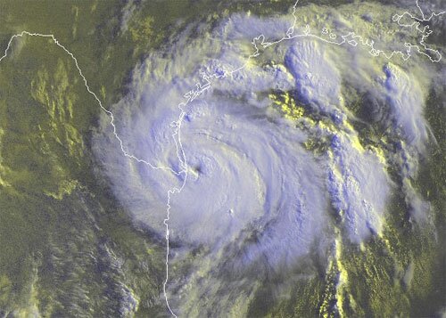
Dolly is getting ready to land on the US coastline at the Texas/Mexico border, near the mouth of the Rio Grande. The image below, taken at 9:15 on Wednesday clearly shows the hurricane’s eye:

Hurricane Dolly makes landfall on the Texas Coast

She will be the first hurricane to affect the US coastline this year, and is likely to cause intense flooding along the Rio Grande valley. Maximum winds have reached 95 MPH, and the storm is likely to be border Category 2 when landfall occurs late this morning. Most areas will get 6-10 inches of rain with over a foot of precipitation in some locations.

Moist tropical air from Dolly is affecting Georgia, and was responsible for many of yesterday’s thunderstorms. As usual, amounts varied widely, with 1.19 inches in Marietta, .29 inches at Peachtree DeKalb, .28 inches at my Lawrenceville weather station and only .16 inches at Hartsfield airport. Athens remained dry.

Even though the rain amounts were less than what one might have hoped for in a drought, the sudden drop in temperatures–eight degrees in 11 minutes here–very gusty winds and at least five tornado warnings issued in Gwinnett County made it an interesting evening. Look for more of the same this afternoon as a cold front passes through.

Sphere: Related Content

Share

Metro Atlanta Rain Totals Last Week

Monday, July 14th, 2008

I received a nice note from a blog reader in northeast Cobb county reporting that they got quite a bit of rain over the last week. He estimated that about ten inches had fallen where he lives. Well, 10 inches would be quite a lot of rainfall — more like what we would see as the result of tropical weather, and looking at some of the estimated precipitation data from the weather service, they don’t have anything like that reported. That being said, it looks like Marietta did have the highest amount of rainfall over the last week.

From July 7th through yesterday, here are the rainfall totals for some metro Atlanta locations:
Athens: 2.79 inches
Atlanta: 3.91 inches
Gainesville: 1.92 inches
Marietta: 4.18 inches
Chamblee (Peachtree DeKalb): 2 inches
West Atlanta (Charlie Brown): 1.83 inches

For the month of July so far, here are some totals:
Athens: 3.31 inches
Atlanta: 4.82 inches
Allatoona Dam: 6.07 inches
Alpharetta: 3.1 inches
Ball Ground: 5.55 inches
Carrollton: 1.52 inches
Gainesville: 1.92 inches
Helen: 4.45 Inches

Here in Lawrenceville, I’ve recorded 2.03 inches for July to date. So, it’s fair to assume that locations in the northwest got more rain than did those on the east or south of Atlanta. July is typically the rainiest month on average for Atlanta, with 5.12 inches in a typical year. However, the capriciousness of thunderstorms means that rainfall amounts can vary widely, even over a relatively small area.

We probably won’t have to worry too much about rain for the next few days. Behind the cold front that pushed through last night is much drier air, and you’ll see low humidity and dew points for the next few days. That also means cooler evening temperatures, and no weather problems for the primary election on Tuesday.

Sphere: Related Content

Share

The Randomness of Thunderstorms

Monday, June 23rd, 2008

This weekend’s thunderstorms didn’t bring much drought relief to Gwinnett county, despite the tempting red splotches on the radar all around. Saturday morning brought less than a tenth of an inch at my house, and then nothing for the rest of the weekend.

Other locations did see a reasonable amount of precipitation, though. A storm passing through early Sunday morning and some afternoon rainfall brought .78 inches of rain to Covington–the most rain recorded in North Georgia on Sunday. Meanwhile rainfall amounts varied a lot, even at relatively close distances. Marietta recorded .73 inches on Sunday, while nearby Charlie Brown Airport in Atlanta got not a drop. In Cartersville, they had a quarter of an inch, while Rome received only trace precipitation. Atlanta, which has recorded a scant .23 inches of rain for all of June ended Sunday with only 1/100 of an inch of rain.

The weather over the last week or so has featured an upper level trough over the east coast that has tended to keep tropical air from the Gulf of Mexico away. Thus dew points have been relatively low, making it harder to generate thunderstorms. The rain we’ve had has been caused by small disturbances traveling on the edge of the trough. That is likely to change later in the week, as the trough moves out and moist air returns. However after this evening, we’re not likely to have a good chance for precipitation until the weekend.

Sphere: Related Content

Share

Tornadoes Strike North Georgia

Saturday, March 15th, 2008

The last 24 hours have brought perhaps the most significant severe weather to North Georgia since the Dunwoody tornadoes back in April, 1998.

National Weather Service officials said that a F2 tornado touched down at Simpson Road and Burbank Drive just west of the Georgia dome at 9:38 PM Friday night. The 200 yard wide twister traveled through downtown Atlanta and proceeded about six miles, until it ended at Braeburn and Josephine Roads in DeKalb County.

There was extensive damage to the Georgia Dome, where viewers of the SEC Basketball tournament were surprised when things began to sway. Additional damage was reported throughout downtown, including the CNN building and Centennial Olympic Park. Fortunately, no one was killed in the evening storm. You can read about the storm here, here and here.

(more…)

Sphere: Related Content

Share