Get Forecast For:
Lawrenceville Weather

Temperature Records Fall in North Georgia

Monday, July 20th, 2009

Extremely unusual weather for mid-July has broken low temperature records around the state, with much of Georgia seeing late September like weather during what is normally the warmest stretch of the year.

On Sunday, Atlanta tied a record low of 63 degrees, set in 1967. The low in Athens of 58 beat the prior record of 62 set in 1925. In Columbus, it was 62 degrees Sunday morning, breaking the previous low of 66, set in 1987. And in Macon, a low of 58 beat the old record of 61, set in 1967.

Monday morning’s low of 61 in Atlanta tied the previous record, set in 1946. In Athens, a low of 60 degrees broke the almost 100 year low record of 61, set in 1910. In Columbus, a low of 64 also tied the previous record, set in 1946. And in Macon, a low of 61 beat the previous low of 62, set in 1987.

There’s another chance for record lows tomorrow morning before the weather starts returning to normal during the latter part of the week. A stationary front located near the Georgia-Florida border is keeping the normal summertime humidity from the Gulf coast from moving north, and the exceptionally dry air is letting daytime heat escape into the clear night skies.

The normal high for July 20th is 88 degrees, and the normal low is 70.

Sphere: Related Content

Share

Time for a Turn to the Hot, Sticky Season

Wednesday, June 25th, 2008

With the exception of last weekend, the last two weeks have brought us low humidity and warmer temperatures than normal. That’s going to change this weekend, as the weather pattern changes to a Bermuda High, and moisture from the Gulf. While June, July and August are, meteorologically speaking considered the summer months, it’s July and August when the humidity becomes its most oppressing.

Looking over 2005-07, as measured by my humble weather station here in Gwinnett, the average June temperature has been 75.1 degrees, while the average June dew point has been 63.25. There’s been roughly a 12 point difference between the temperature and the dew point. This year, June’s average temperature has been 77.3, with a dew point of 63.1, a 14 point difference. We’ve been warmer and drier than we have in recent years.

Compare this to July, where the average temperature has been 77.3 degrees, with an average dew point of 68.4, about a 9 point difference, and August, where my Atlanta area weather station recorded an average temperature of 78.9 and an average dew point of 70; again about a nine point difference. The closer the temperature is to the dew point, the greater the humidity.

By September, things get more comfortable, with an average temperature of 72 degrees and an average dew point of 62.7. There’s still about a 9 point difference between the two, but the cooler average temps make conditions much more tolerable.

The good news about the pattern change is that the chances of rain go way up beginning tomorrow night and lasting through the weekend. In fact, one model is even predicting a tropical storm in the Gulf, although this isn’t supported by other models, nor the National Hurricane Center. In addition to increased chances of afternoon thundershowers due to the unstable moist air, there’s even the possibility of an unusual late June cold front pushing through over the weekend, increasing the chances of rain.

Sphere: Related Content

Share

Hottest Weather of the Summer This Week

Sunday, August 5th, 2007

Despite a relatively cool July —the mean July temperature was actually cooler than the mean June Temperature, both here in Lawrenceville and in Atlanta— it looks like August is going to be our hottest month of the year.

The short range, medium range, and long range forecasts are all calling for warmer than normal temperatures, and it looks like we may not get much rain to help out, at least until the middle of the month.

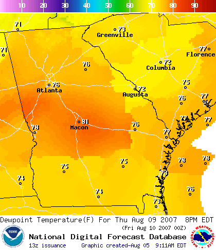
Temperatures will be approaching the 100 degree mark all this week in North Georgia. To make things worse, we’ll likely be seeing high dew points as well. That means that the humidity will be approaching the unbearable range. Take a look at the forecast dew points in Georgia for 2 PM Thursday:

If this forecast validates, we’ll see the heat index above 105 degrees, the danger level, several times this week.

Ultimately, it’s the moisture in the air that determines how we feel when we go outside. Although relative humidity is the measurement most people use to measure moisture content, the dew point temperature can provide a better measure of how uncomfortable conditions are. When the dew point rises to near 70 or above, most people are unlikely to want to be outside for very long.

The heat index also measures the apparent temperature. For more detail, take a look at this table showing the relationship between relative humidity, temperature, heat index, and dew point.

The reversal from the cool and wet July conditions to the hot and dry conditions for August isn’t going to do much to help the drought conditions in Georgia. Over the last month, the drought levels in Georgia haven’t changed very much. While the rain has kept lawns green in the short term, we will see a quick return to brown lawns without more rainfall.

As I’ve said before, tropical weather will probably be the key to breaking the drought. Despite the relatively quiet season so far, the latest forecast by Dr. Gray at Colorado State University is still calling for an above average hurricane season. The researchers are predicting 15 tropical storms for the season, down 2 from their May forecast, and eight hurricanes, down from nine in May. There’s also an above average chance of a major hurricane striking the US coast.

Sphere: Related Content

Share

High Humidity Marks Summer’s Second Heat Wave

Sunday, August 21st, 2005

The dewpoint on Saturday measured 78.6 degrees late in the morning, which is the highest measured so far this year. With the temperature around 85 degrees at the time, the heat index felt like it was 95. By 2 PM, the temperature had risen to 92, and with the dew point still at 76, the heat index stood at 104.

That’s still not the highest heat index for the year, which was 106 on July 27th. On that day, we had the warmest temperature of the year, at 97, however the humidity was lower.

Look for one more day of unpleasantly hot and humid weather on Sunday before things begin to back off a bit going into the latter part of the week. While the cold front that could have brought a taste of fall will stay to our north, we’ll enjoy a few days with highs in the mid 80s.

The forecast for next weekend and into the beginning of the last week of August is for a chance of cooler than normal temperatures, and below normal precipitation. An extended forecast into Labor Day weekend calls for slightly above-normal temperatures, but still below normal rainfall.

Sphere: Related Content

Share

California Weather Visits Atlanta

Tuesday, May 24th, 2005

I couldn’t let the day go by without commenting on the absolutely glorious weather we’ve been having. For today, we had a high of 81 degrees. With the dew point as low as 42 degrees, the humidity was a low 27% shortly after noon. These humidity levels are reminiscent of March (with equally March-like winds). The pleasant weather should continue through Friday, with higher humidity and a slight chance of showers over the weekend.

Overall, the May weather hasn’t been anywhere close to normal. We are on track to having one of the driest Mays ever, with only 8 tenths of an inch. Overall temperatures and humidities have been lower than normal as well.

One measure of the lower temperatures is the number of cooling degree days we’ve seen so far this year. Cooling degree days (and their complementary heating degree days) are a measure of how the temperature varies from 65 degrees. Temps above 65 bring more cooling degree days, while lower temperatures bring more heating degree days. So far this year, we’ve had just under 200 cooling degree days; last year at this time, we were at 300.

You can also look at the average relative humidity for this month, compared to more normal years. The mean relative humidity this month so far is 67%, compared to a 78% average from 2002-2004.

Our good weather is the result of a persistent major upper level low, or trough, over Eastern Canada, more typical of what we would see in winter rather than late spring. That low is wreaking havoc in the Northeast, where Boston had high temperatures this week in the upper 40s, and a major Nor’Easter is pounding the coast.

The low is preventing the normal pattern of warm, humid air moving from the Gulf Coast through Georgia, and north through the Mid-Atlantic States. Instead, we are getting drier, cooler air from the Northwest, which can’t follow its normal pattern across the Northeast because of the blocking low.

Forecasters predict that the Northeastern low is likely to break up sometime over the weekend, bringing us more typical weather for the start of June. On the other hand, the National Weather Service predicts lower than normal temperatures for our area through the first week of June. It all depends on how soon the trough on the East coast breaks up.

Sphere: Related Content

Share