

Winter Isn’t Over Yet in Atlanta
Tuesday, March 1st, 2005With the start of the new month, it’s time to take a look back at February, and a look ahead to March. Here in Lawrenceville, we had a low of 26.9 degrees on the 11th, and a high of 73.2 on the 22nd, with a mean temperature of 47.4 degrees, about two degrees warmer than normal.
For precipitation, we recorded 5.3 inches of rain, or about half an inch more than normal, when you figure in averages for Atlanta and Athens. About two inches of that came in on President’s day, when the year’s first severe thunderstorms and hail pounded the area. Overall, though, we’re still about an inch and a half below normal precipitation, due to the extremely dry weather in January.
I dutifully looked at the National Weather Service’s updated monthly forecast this morning, and saw what looked a lot like the maps I posted back on February 17th. The main difference is that it’s now predicted to be colder than normal out through Arkansas and Missouri, where before it was only supposed to be colder in Louisiana and southern Mississippi.
What I found more interesting was this graphic of predicted 6-10 day temperatures:

The entire eastern half of the country will be colder than normal, and the western half will be warmer than normal.
This unusual situation is being caused by what the forecasters say is “a high PNA combined with a negative NAO and a blocking ridge over Iceland”. Translated into English, that means that high pressure aloft over the Pacific Northwest forces the cold, Arctic air down over the Great Plains until it lands at the East coast, where it is blocked by the high pressure over the North Atlantic. Right now, there is no end to this pattern in sight – we should continue through mid-March with highs only reaching the low 60s, and the reason we’ll be that warm is that the sun is getting fairly high in the sky, and providing daytime heating. At night, it will still go down to around freezing.
So, what about precipitation? Forecasts for the month call for equal chances of above or below normal precipitation north Georgia for the month. A storm later this week is likely to pass to our south and spoil spring break in Florida, and models show another chance of wet weather on the 8th, the 12th, and again around St. Patrick’s day. Keep in mind, though, that models that far out can change considerably within a few days, so this is by no means definite. I still think that we have a chance to see some more wintry weather, although it may turn out to be no more than this morning’s flurries.
Sphere: Related Content A band of flurries passed across the area between 4 and 5 this morning, and additional light snow was reported through about 10 AM.
 These two pictures show some light snow covering my yard, and the surrounding street. Although a few areas reported icy patches during the morning drive, all in all, the snow is not a problem, and won’t last, as the skies will clear during the day.
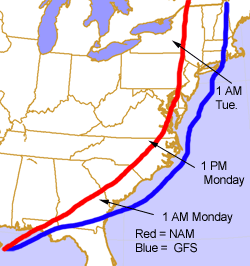 The path of the storm will determine whether the northeast gets rain, snow, or a blizzard. The image to the right is my crude drawing of the storm’s expected path, based on the 6Z Sunday runs of the GFS and NAM forecast models. The NAM prefers a more inland route, while the GFS shows the low moving out to sea, before getting back on land in Rhode Island.
 The Weather Channel was reporting an inch of sleet as of late afternoon in metro Atlanta. By Saturday night, you could hear the trees crackling as the wind blew, and over 100,000 Georgia customers had lost power due to the storm. The good news is that by 10 AM on Sunday, temperatures will begin to warm up, with a high on Sunday of 44.