Get Forecast For:
Lawrenceville Weather

Dean Just South of Jamaica
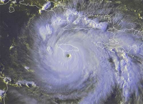
Sunday, August 19th, 2007

Hurricane Dean, still a category four storm, is just south of Jamaica this evening. The satellite picture below was taken about 6:15 PM on Sunday, and shows the eye just below the island.

The storm is expected to intensify to category five as it heads almost due west, and will next travel over Yucatan sometime on Tuesday. The following day, it lands on the coast of Mexico, and will still be a tropical storm a day later as it will be inland.

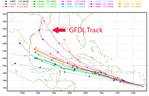
Dean might be one of the most powerful storms measured since storm naming begun. Th tropical season is in full swing now, and it’s quite possible that a future storm Felix is brewing out in the Atlantic, and we might be paying attention to it by next weekend.

Meanwhile, something needs to be done to break the heat and drought in the southeast. Atlanta has already broken the record for number of 100 degree or more temperatures in a summer, and we could have more days with highs past the century mark this week. While the remnants of Erin earlier this week are bringing welcome rain to much of the nation, Georgia is staying stubbornly dry. Based on the current long range outlook, it could stay warm and dry until the end of the month.

Sphere: Related Content

Share

Hurricane Dean Develops into Category 3 Storm

Friday, August 17th, 2007

Hurricane Dean has been intensifying over the past few days, and is now a Category 3 storm, with winds of 125 MPH, and a very distinct eye. By Sunday afternoon, he should be directly over the island of Jamaica, and just approaching being a Category 5 storm. A hurricane watch is out for the island.

The map above shows the a number of forecast tracks for where Dean will go after passing south of Cuba. While the consensus forecast is to keep the storm on a westerly track, notice the forecast of the GFDL model, which moves the storm northwest, and towards Louisiana. While this forecast is an outlier, the GFDL model has a tendency to be accurate, and the National Hurricane Center has noted this in its discussion, which assumes that the high pressure ridge over the southeastern US will keep Dean to the south. It will be early next week before the situation becomes clearer, but it appears this storm will be one to keep an eye on.

Meanwhile, here in Atlanta, my front yard looks like it’s the first week of October, rather than the third week of August. The almost complete lack of rainfall since the first of the month has brought the effects of the drought back with full intensity, and the dogwood and tulip trees are showing the strain by dropping their leaves.

While there are some storms in the area this evening, August has rapidly taken away any improvement we saw in our cooler, wetter July. The good news is that from this time next week through the end of the month, there’s a better than normal chance of rainfall, and this trend has been holding for the last two or three outlooks.

Meanwhile, the National Climate Data Center issued its temperature and precipitation summary for July. Georgia ended up with cooler than normal temperatures (30th coldest of 113 years), and near normal precipitation (45th driest out of 113 years). Montana, Idaho, and Wyoming had their warmest months ever, while Texas and Louisiana had their third wettest July ever.

Sphere: Related Content

Share

Two Storms Threaten to Become Hurricanes

Wednesday, August 15th, 2007

After two months of doubting Thomases saying “What hurricane season?”, we not have two tropical storms, at least one threatening to become a hurricane, and both threatening the Gulf of Mexico.

he most immediate threat is Tropical Storm Erin, shown below. Seemingly cropping up out of nowhere last last night, the storm is gaining strength, and before it hits landfall, it should have wind speeds of 63 MPH, about 10 MPH short of hurricane strength. Tropical storm warnings have been posted for South Texas from San Luis Pass southward. While the exact landing point sometime Thursday isn’t certain, storm force winds extend 70 miles out from the center of the storm, and much of the Texas Hill Country could get more than 6 inches of rain — if they haven’t had enough already.

The next actor in this play of tropical weather is Tropical Storm Dean, which will likely become a hurricane by Thursday morning. Dean’s track is shown below:

Dean has been moseying along for a few days now, but is rapidly gaining strength as he approaches the Caribbean. Expected to pass just south of Jamaica on Sunday, the real question is what happens once he reaches the Gulf of Mexico sometime Monday evening. The high pressure system that’s giving Atlanta 100 degree temperatures for the second week in a row is powerful enough at the present time to prevent the storm from recurving to the north.

If the ridge stays strong, the storm will slam into the Yucatan peninsula of Mexico, and some of the models show this to be happening. if it weakens, then the US Gulf is vulnerable to what could be a very powerful hurricane. Since whatever happens is more than five days out, even the best forecasters (and I’m not one of them) aren’t sure what will happen.

Sphere: Related Content

Share

Tropical Depression Four Forms in Atlantic

Monday, August 13th, 2007

The National Hurricane Center has officially recognized Tropical Depression Four, which lies in the mid-Atlantic with winds of 35 MPH. It is expected to become Tropical Storm Dean sometime on Tuesday morning. and is projected to become a hurricane by the weekend, when it may be close to the Virgin Islands, headed towards Cuba.

You can view the storm’s projected path here, and view a satellite image here.

At this point, it’s too early to tell where the storm will ultimately make landfall, short of saying it will probably be somewhere in the Gulf of Mexico.

Atlanta’s hot weather got a break on Sunday, when a summertime version of the wedge brought east winds, and cloud cover that lasted through mid afternoon, and kept high temperatures in the 80s. After four days of record-setting heat (another temperature record was broken on Saturday), I’m sure everyone enjoyed the break. We could see more records broken this week, with high temperatures in the upper 90s through Friday. By that time, we’ll be in a better position to see what effect Dean will have on Georgia.

Sphere: Related Content

Share