Get Forecast For:
Lawrenceville Weather

Record Cold Hangs On

Sunday, January 10th, 2010

It seems like the cold weather just doesn’t want to go away. With the turn of the new year, the weather pattern changed as well, with high pressure systems over the Plains states and off of New England forming an opening between to allow unusually cold air to sweep southward. Mix that with a non-existent southern jet stream, and the cold moves across the eastern seaboard.
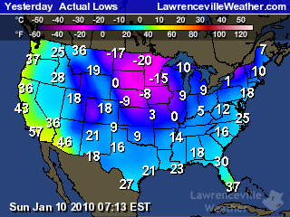
The map to the right shows the low temperatures across the country on January 9th. For the first ten days of the month, the mean temperature I’ve recorded here is 27.5 degrees–below the normal low for this time of year, which should be 33. The mean temperature for the same period in 2009 was 49.9.

We haven’t seen record cold, though. The lowest temperature I recorded here through the period was 13.5, last seen on January 16, 2009. The 13.9 chiller ties the record for the coldest temperature my thermometer has measured over the last eight years. Official records from Atlanta Hartsfield put the low records for the first ten days of the month in the single digits.

The good news (if there is any) is that with the extremely cold temperatures, we didn’t get a lot of precipitation. The snow on Thursday amounted to less than half an inch in my yard. Panic, school closings and shortages of bread and milk all occurred, but that’s par for Atlanta. I don’t know how much liquid precipitation fell on Thursday–snow and my rain gauge don’t play well together–but it was the longest stretch without rain since the latter part of November.

Elsewhere, heavy snow and cold led to snowplows being thwarted in the Midwest, and even snow flurries reported in Miami yesterday by the National Weather Service:

BY THE WAY…COUPLE TRAINED WEATHER SPOTTERS REPORTED A FEW SNOW FLURRIES IN THE WEST BOYTON BEACH… AND A FEW SMALL ICE PELLETS IN PALM BEACH THIS EVENING WITH THE RAIN SHOWERS. ANOTHER TRAINED STORM SPOTTER IN BROWARD COUNTY REPORTED A FEW FLURRIES IN OAKLAND PARK WITH THE LIGHT RAIN SHOWERS EARLY THIS EVENING…ALONG WITH A TRAINED SPOTTER IN MIAMI-DADE COUNTY REPORTING A FEW FLURRIES WITH SOME SLEET JUST SOUTHEAST OF TOWN AND COUNTY MALL.

It has been interesting to watch the forecasts over the past few days. Earlier last week, forecasts were predicting 50 degree temperatures today. It got up to 34. By Thursday, it’s supposed to be in the upper 50s. Want to bet it gets there? The models used to forecast upcoming weather assume that cold spells in the southeast are somewhat short-lived, so they try to get back to normal temperatures fairly quickly. This bias is what causes predictions of an earlier than actual warmup.

It will warm up. The North American Oscillation, which is a good indicator of temperatures on the east coast is trending positive, and the 6-10 and 8-14 day forecasts call for warmer than normal temperatures in the southeast. But, I wouldn’t be surprised to see another one or two rounds of colder than normal temperatures before winter ends in March.

And of course, when it finally does warm up by next weekend, what are we going to get? Significant rainfall and a chance of flooding. But that’s a topic for another post. And for those that asked I will try to post more. Blame the holidays and a busy schedule.

Sphere: Related Content

Share

Storms and Rumors of Storms

Friday, January 30th, 2009

While the last two weeks have been relatively quiet weather-wise in Atlanta, that certainly hasn’t been the case elsewhere in the country. a massive storm earlier this week brought snow, then ice, then more snow to a wide area from Arkansas to Pennsylvania, with Kentucky perhaps suffering the most. State officials there are calling the power outage caused by the ice storm the worst in the state’s history. Chicago has had six or more inches of snow on the ground for the last 20 days, a top ten record, and as of yesterday is recording its third coldest January on record, with a mean temperature of 15.8 degrees, more than six degrees below normal.

Despite a general impression of a cold January in Atlanta, it’s actually been warmer than normal. At Hartsfield, the mean temperature through today is 44 degrees, 1.3 above normal. It’s been a bit cooler here in Lawrenceville, with a mean of 42.5 degrees, but that’s to be expected. The January mean temperature in 2008 was actually over a degree cooler than this year, although 2007 and 2006 were both above normal.

After this weekend, which could be quite pleasant, we have the threat of the worst storm of the winter season. The eyes of the weather world are focusing on Monday and Tuesday, when a powerful storm will start in the southeast and move north, bringing a chance of snow to North Georgia, and likely a doozy of a storm to the mid-Atlantic states.

Most of the country’s weather this winter has been affected by the northern branch of the jet stream. In essence, the northern branch divides cold Canadian air from the (slighly warmer) air to the south. It can dive south, as we saw mid-month when we got the coldest temperatures of the season. For the first time this winter, the southern branch is also active as well. The southern branch divides warmer, tropical air to the south and the colder air to the north. When these two branches join back up, you have a good possibility of wintry weather.

The forecast models have been changing from run to run on the position of the two jet streams, and where the snow will fall, but there is a definite possibility that Atlanta could see some wintry weather on Monday or Monday night. In the worst-case scenario, we could see something like what happened in March, 1993, when the Atlanta area got over a foot of snow. Or, we could get just rain, and not much rainfall at that. Keep your eyes on the forecast over the weekend to get updates.

The History of the Global Warming Argument

The founder of the Weather Channel, John Coleman, has published a blog entry describing the history of the global warming (or climate change, to use the current PC term) debate. Coleman says there is no basis for the climate change threat, which he argues was blown way out of proportion because a researcher was looking for more government funding.

Sphere: Related Content

Share

Warm Weather Brings out Early Spring

Saturday, January 6th, 2007

With temperatures recorded at Hartsfield Airport in Atlanta 4.5 degrees above normal for December as a whole, and 8.9 degrees above normal for the first six days of January, one could be forgiven for asking, “What happened to Winter?”

Even Mother Nature seems confused. Looking around the yard, I have a few daffodils blooming, the Lenten Roses have bloomed, and I even see that the Daphne is beginning to bloom. On Ronald Reagan Parkway, the Pussy Willows are coming out. All of this is about a month ahead of schedule. In New York City, the entire month of December went without any measurable snowfall–the first time that has happened since recordkeeping began.

The US has been in what’s called a split flow jet stream pattern for the last month or so, with the northern jet stream moving west to east across the northern states, and the southern jet stream moving across the southern states. The effect of this is to keep all the cold Canadian air north of the border, and to bring fronts across the Gulf of Mexico, which is what we saw with the Christmas Day storms, which brought tornadoes to central Florida, and yesterday’s storm, where a violent squall line brought an F1 tornado to the McDonough area, and rain across much of Georgia around lunchtime.

This benign weather pattern will break down by the Saturday the 13th, bringing cold air out of Canada initially into the Plains states, and then moving further east. For the week of January 15th, the Atlanta area will be lucky to see high temperatures of 50 degrees. Beyond then, we’ll likely see more typical winter weather through February.

Before then, we’re going to get two storms. Rain tomorrow could bring 1.5 inches to the area, as a front will stall over Georgia during the day. Things clear out for the work week, with somewhat lower but still relatively warm temperatures and nice weather until next weekend, when another front ahead of the colder air again brings the possibility of rainfall.

So, if your outdoor plants seem a bit overeager, don’t worry too much. There will be plenty of colder weather to slow them down.

Sphere: Related Content

Share

Warmer Than Normal Weather Could Continue Another Week

Friday, December 30th, 2005

For the last three years, we’ve had a warm up from normal winter temperatures right around the new year. In 2005, daily highs were above 65 for the first 13 days of the year. For 2004, New Year’s Day saw 72 degrees, and high temperatures stayed above 65 until the 6th. 2003 also saw temps above 60 the first week of the year. This year, it will be a bit cooler, but still more reasonable than the cold weather we had during the first part of the month.

We are in the middle of what’s called a split-flow jet stream pattern. Instead of a single dominant jet running from west to east, one branch is staying roughly along the US-Canadian border, keeping the colder air well to the north. A second southern jet stream is moving through the middle of the country, bringing milder Pacific weather to the south. This type of pattern also tends to bring frequent, short storms to our area, similar to what we would normally see in March.. The end result is that we alternate between beautiful days like today and the clouds and rain (and even thundershowers and tornadoes) we saw on Wednesday.

Look for a chance of rain late tonight and early Saturday, and then again on Monday and Wednesday. (During this type of pattern, look at what the weather was in California two or three days ago). California this week has been soaked by rain, with up to 7 inches expected by the end of the weekend.

By the end of the first week in January, however, a more traditional winter pattern is expected to emerge, bringing cooler weather back to metro Atlanta, and snow back to the Midwest.

Sphere: Related Content

Share

Remember that Yellow Thing?

Thursday, February 3rd, 2005

It seems like forever since we’ve had a really nice day. Despite the fact a week ago yesterday, I was able to sit outside at a coffee shop downtown, enjoying a high of 68, things went downhill quickly, and I think just about everyone is willing to forget this first week of February.

The bad weather here this week is in sharp contrast to what has been happening in the rest of the country. What we’ve seen is what weather folks call a ‘split flow’ pattern, where the northern jetstream doesn’t go much below the Canadian border, and the southern jetstream comes north and bothers the Southeast.

This has led to temperatures forecasts for today of 62 degrees in Billings, Montana and 64 degrees in Rapid City, South Dakota. These are places where normal highs for early February are about 25 degrees.

The weather pattern is about to change, though, and Atlanta is headed for a warm-up, at least for a few days. Over the weekend, we should see 60 and very nice weather, with a moderate possibility of rain all next week, although still warm, with daytime highs in the upper 50s to low 60s, and nighttime lows in the 40s.

This is happening as a cold air mass prepares to move down from Canada and into these same areas that are enjoying warm temperatures today. By Tuesday in Rapid City, the forecast high is 20, with a low around 8.

We start to feel the effects of this next Friday and Saturday, which will be the first time temps drop back below the freezing mark. Overall, the National Weather Service forecast calls for above normal temps through the middle of next week, normal temperatures from the 9th through the 13th, and below normal temps until the 17th.

If there’s any consolation to all of this, it’s that less than normal precipitation is predicted for the next two weeks.

Wind Speeds

Weather Forecasting 101

Wind direction can tell us a lot about what is going to happen with the weather in the short term. To the right is today’s wind direction plot, which shows a transition from mostly easterly winds before noon, to mostly westerly winds after noon. The change in wind direction meant the end of the clouds and rain was coming, and indeed, by late afternoon, the sun was shining.

Sphere: Related Content

Share