Get Forecast For:
Lawrenceville Weather

A Change in the Weather

Sunday, September 14th, 2008

One of the effects of all the tropical weather we’ve had over the past few weeks is that it has largely kept the warm, humid air around longer than normal. While daytime temperatures this month have been normal to slightly above normal, it’s the nighttime lows that haven’t been allowed to get to their typical 65 degrees because of the moisture in the air. Through yesterday, Atlanta is 3 degrees warmer than usual for the month.

After tomorrow, that’s going to change, and in fact for a few days, North Georgia will have temperatures lower than normal.

As the remnants of Hurricane Ike race northward, a cold front will reach the Atlanta area late Sunday night, bringing a chance of rain as the front passes through tonight and tomorrow. By Monday night, lows will drop into the low 60s, and for the rest of the week, we’ll see pleasant weather, with highs around 80, lows possibly in the upper 50s, with much lower humidity.

For the week of the 21st, we could see overnight temperatures in the low 50s, still a bit cooler than the normal low 60s. Fall starts a week from Monday, and we’re in the time of year when the average daily temperature drops rapidly. In September, the average at the beginning of the month is 76 degrees, while by month’s end, it drops to 68. By Halloween, the average Atlanta temperature is 58.

In addition to causing rising gasoline prices (and some gas shortages), Ike was responsible for plenty of destruction in south Texas. Although it was a category 2 storm on the ground at landfall, there were category 4 wind speeds a few hundred feet in the air, causing significant damage to Houston skyscrapers.

But, it wasn’t the ultimate storm that some were predicting. Ike made landfall about 30 miles east of what was predicted by the Hurricane Center. That small change in path meant that instead of 22-25 foot storm surges that would have been pushed up the Houston ship channel, the maximum appears to have been only around 12-13 feet; something the area was better prepared for.

The good news is that two major American cities, New Orleans and Houston, each were spared from catastrophe from Gustav and Ike. The risk is that with warnings of Gustav being “the storm of the century” from New Orleans Mayor Ray Nagin, and weather service warnings of “certain death” from Ike, residents of storm-prone regions may be less willing to evacuate if and when the big one comes.

Sphere: Related Content

Share

Ike Likely the Storm of the Year

Friday, September 12th, 2008

I haven’t said too much recently about Hurricane Ike, mainly because I’ve been busy this week with other projects, and because there has been plenty of coverage in the media. That being said, I think that after the storm passes through Texas, it will probably be recognized as the storm of the year, comparable to Katrina three years ago.

Take a look at the Houston weather forecast. For Saturday:

Saturday…Hurricane conditions expected. Showers and thunderstorms. Some thunderstorms may produce heavy rainfall. Highs in the mid 80s. Southwest winds 45 to 65 mph with gusts to around 90 mph in the morning Decreasing to 30 to 40 mph with gusts to around 65 mph in the afternoon. Chance of rain near 100 percent.

The real danger from Ike won’t be the amount of rain, nor will it be that the storm will remain over Harris County causing wet weather for days, as Fay did in north Florida. Instead, it’s going to be the storm surge across Galveston Bay and into the shipping canal that serves Houston. Surges of up to 20 feet are predicted, and the Weather Service is warning,

MANY RESIDENCES OF AVERAGE CONSTRUCTION DIRECTLY ON THE COAST WILL BE DESTROYED. WIDESPREAD AND DEVASTATING PERSONAL PROPERTY DAMAGE IS LIKELY. VEHICLES LEFT BEHIND WILL LIKELY BE SWEPT AWAY. NUMEROUS ROADS WILL BE SWAMPED… SOME MAY BE WASHED AWAY BY THE WATER. ENTIRE FLOOD PRONE COASTAL COMMUNITIES WILL BE CUTOFF. COASTAL RESIDENTS IN MULTI-STORY FACILITIES RISK BEING CUTOFF. CONDITIONS WILL BE WORSENED BY BATTERING WAVES CLOSER TO THE COAST. SUCH WAVES WILL EXACERBATE PROPERTY DAMAGE…WITH MASSIVE DESTRUCTION OF HOMES…INCLUDING THOSE OF BLOCK CONSTRUCTION. DAMAGE FROM BEACH EROSION COULD TAKE YEARS TO REPAIR.

VERY DANGEROUS WINDS WILL PRODUCE WIDESPREAD DAMAGE AND DESTRUCTION OF MOBILE HOMES IS LIKELY. STRUCTURAL DAMAGE WILL INCLUDE THE MAJORITY OF MOBILE HOMES BEING SEVERELY DAMAGED. THOSE THAT SURVIVE WILL BE UNINHABITABLE UNTIL REPAIRED. HOUSES OF POOR TO AVERAGE CONSTRUCTION WILL HAVE MAJOR DAMAGE…INCLUDING PARTIAL WALL COLLAPSE AND ROOFS BEING LIFTED OFF. MANY WILL BE UNINHABITABLE. WELL CONSTRUCTED HOUSES WILL INCUR MINOR DAMAGE TO SHINGLES…SIDING…GUTTERS…AS WELL AS BLOWN OUT WINDOWS. UP TO ONE QUARTER OF GABLED ROOFS WILL FAIL. PARTIAL ROOF FAILURE IS EXPECTED AT INDUSTRIAL PARKS…ESPECIALLY TO THOSE BUILDINGS WITH LIGHT WEIGHT STEEL AND ALUMINUM COVERINGS. OLDER LOW RISING APARTMENT ROOFS MAY ALSO BE TORN OFF…AS WELL AS RECEIVING SIDING AND SHINGLE DAMAGE. UP TO ONE QUARTER OF ALL GLASS IN HIGH RISE OFFICE BUILDINGS WILL BE BLOWN OUT. AIRBORNE DEBRIS WILL CAUSE DAMAGE…INJURY…AND POSSIBLE FATALITIES.

NATURAL DAMAGE WILL INCLUDE ALL TREES WITH ROTTING BASES BECOMING UPROOTED OR SNAPPED. NEARLY ALL LARGE BRANCHES WILL SNAP. BETWEEN ONE QUARTER AND ONE HALF OF HEALTHY SMALL TO MEDIUM SIZED TREES WILL BE SNAPPED OR UPROOTED…MOST COMMON WHERE THE GROUND IS SATURATED. UP TO THREE QUARTERS OF NEWLY PLANTED GROUND CROPS WILL BE DAMAGED.

The unspoken threat in the above is the possible damage to the energy refining and chemical production facilities along the coast. Some people are reporting gas stations already charging upwards of $4 per gallon. I noticed gas prices have risen by 10-15 cents since yesterday. We’ll know more by tomorrow evening, but this looks like one of the worst storms to hit Texas ever.

Here in North Georgia, we’ve been feeling the effects of the approaching Ike. While there hasn’t been a lot of rain, the tropical dew points have delayed the typical September days of lower humidity and lower temperatures at night. After a warm weekend, you can expect more seasonable weather by the middle of next week after Ike moves out. In the meantime, hope for the best for Houston.

Sphere: Related Content

Share

With Hanna Out of the Way, All Eyes Turn to Ike

Sunday, September 7th, 2008

Topical Storm Hanna ended up not causing as much damage as it could have, making landfall Saturday morning near the North Carolina/South Carolina border with winds bringing it close to but not quite hurricane strength. Over the course of Saturday, it moved rapidly north disrupting, among other things, the NASCAR night race at Richmond, Virginia and the US Tennis Open in New York. The storm has become extratopical, and is now heading east towards the United Kingdom.

Hanna’s rainfall will help ease drought conditions in North and South Carolina. Here are some rainfall totals from the storm:

Cape Fear, NC – 3.02 inches
Lumberton, NC – 5.0 inches
Whiteville, NC – 4.47 inches
Wilmington, NC – 2.33 inches
Darlington, SC – 3.1 inches
Myrtle Beach SC – 4.41 inches
Newark, DE – 3.69 inches
Atlantic City, NJ – 2.89 inches
East Brunswick, NJ – 5 inches
Ridgewood, NJ – 4.72 inches
Allentown, PA – 3.06 inches
Philadelphia, PA – 2.27 inches
Manhattan, NY – 3.54 inches
White Plains, NY – 4.42 inches
East Hartford, CT – 6.19 inches
New Canaan, CT – 6.45 inches
Warwick, RI – 4.07 inches
Boston, MA – 2.2 inches
Needham, MA 6.1 inches
North Grafton, MA – 6.41 inches
Nashua, NH – 6.56 inches
Kennebunkport, ME – 5.8 inches
Portland, ME – 5.52 inches

With Hanna (and Gustav) out of the way, the big concern now is Ike, which appears to be the last of this wave of storms that started back on August 15th with Fay. (Josephine faded away from shear a few days ago). Ike is a category 4 hurricane that pretty much demolished Grand Turk Island last night, and at 5 PM was 75 miles northeast of Guantanamo Bay, headed towards landfall on Cuba. The storm is moving west at 14 MPH with 120 MPH winds extending 60 miles from the storm’s center.

The major factor guiding Ike’s path is an upper level high pressure system over the North Atlantic ocean. Ike is underneath this system and is being prevented from moving north. After it crosses Cuba and emerges into the Gulf, Ike is expected to strengthen, and his path will be determined by what happens with the high. If it weakens, Ike may move towards the Florida panhandle. If it maintains its position, we could be seeing landfall somewhere in Louisiana. And, if it were to intensify westward, landfall might be in Texas. Whatever happens, landfall isn’t going to be until late next week or next weekend.

In the meantime, it looks like the Atlanta area may have its first real rain since Fay departed. We are also being affected by the ridge that’s controlling Ike, but it’s possible that a cold front or two may make it this far south midweek. The HPC is predicting up to an inch of rain by Friday. Then depending on where Ike makes landfall, he is expected to move northeast, and may affect our weather by the weekend, although it’s still too early to tell how much.

Sphere: Related Content

Share

Georgia Likely Spared; East Coast to Get Hit by Hanna

Wednesday, September 3rd, 2008

It’s beginning to look like the Georgia coast will be spared any significant effects from Tropical Storm Hanna. The storm’s forecast track has been moving steadily east, with landfall now predicted somewhere around Wilmington, North Carolina, then moving northeast along the coast past Wilmington, Delaware and Wilmington, Massachusetts, and then finally up through Nova Scotia by the end of the weekend.

The real question is how strong Hanna will get before it does make landfall. At this point, it is forecast by the Hurricane Center to be a category 1 hurricane with 80 MPH winds just before landfall. In comparison, Gustav had 115 MPH winds just before making landfall in Louisiana. The Hurricane Center is only calling for a 30% chance of tropical storm winds along the Georgia coast, although high tides and rip currents are definitely likely. Around an inch of rain is predicted along the coast, with far less called for in Georgia’s interior. Atlanta won’t see anything from the storm, and the Bulldogs should enjoy great weather this weekend in Athens.

The east coast could risk a second hit next week with Hurricane Ike, which will be a much more powerful storm than Hanna. By Monday, Ike will be a category 3 hurricane located just a little west of where Hanna is now. Models indicate that an upper level weather pattern may be in place that is similar to what we are going to see in the next day or two, meaning Ike could take a path similar to that of Hanna. But the weather can change, so we’ll have a better sense of what will happen with Ike by the end of the weekend.

The biggest problem in Louisiana, besides plenty of rain, is lack of power. Much of the electrical grid in the Pelican State is down, however the reverse diaspora has begun, and residents are beginning to pick up the pieces. Gustav hasn’t moved very far since arriving in Arkansas, although it will begin to travel north, bringing rain to Wilmington, Ohio and Wilmington, Illinois and should finally be gone by Friday. The HPC is reporting that New Orleans only received 3.1 inches of rain from Gustav–far less than further northwest. Jonesville, Louisiana is still having tornado warnings, and has recorded 17.7 inches of rain through this morning.

Vicksburg, Mississippi got almost 9 inches of rain, as did Hot Springs, Arkansas and Monroe, Louisiana. And, it is continuing to rain, so the final totals will be higher. And, if you want to stay out of the rain this weekend, avoid Wilmington.

Sphere: Related Content

Share

Hurricane Activity to Increase After Gustav

Monday, September 1st, 2008

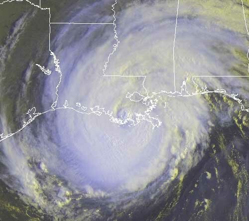
Hurricane Gustav made landfall about 10 AM in Cocodrie, Louisiana, about 70 miles southwest of New Orleans. At this point, it looks like New Orleans will not face a repeat of the disaster brought about by Hurricane Katrina, although I suspect that we’ll know more in the morning. Here’s a satellite picture of Gustav taken about 9:45, just before landfall:

Gustav is expected to linger in the Arkansas/Texas/Oklahoma area for a few days dropping plenty of rain, possibly up to 20 inches in some areas. At some point, it’s going to get picked up by a low pressure system and taken northwest into Ohio. This means that except for the few showers Georgia is seeing today from extended hurricane bands, we aren’t likely to have any effects from Gustav.

Don’t worry though, because there is more where that came from. Hanna was upgraded to a hurricane this morning, about a day faster than what was previously forecast by the Tropical Prediction Center. The latest estimate is that Hanna will not change position much through Tuesday before becoming a category 2 hurricane early Thursday and beginning a northward trek that could lead to landfall in Georgia. The current estimate puts landfall near Savannah sometime on Friday, followed by a rapid move north into the Mid-Atlantic.

There is still some uncertainty over exactly where Hanna will make landfall and the exact strength of the storm when it does, but no matter whether it’s Brunswick, Savannah or Charleston, I wonder if the networks will pay as much attention to Hanna as they are to Gustav. In any case, as I heard Joe Bastardi say on the radio this afternoon, Atlanta and Macon are likely to get only a “glancing blow” from Hanna. Bastardi pointed to Hurricane Floyd back in 1999 as his guess of a comparable storm.

If Gustav and Hanna aren’t going to be drought-busters in Georgia, maybe the third time will be the charm. The Hurricane Center today identified Tropical Depression Eight, which by afternoon became Tropical Storm Ike. Ike has been brewing as a low pressure system off the coast of Africa for the past few days, and will move across the Atlantic fairly rapidly, probably turning into a hurricane by Wednesday. By Saturday, it will be in roughly the same location that Hanna is today.

While it’s too early to tell exactly what will happen to Ike once he approaches the Bahamas. It could follow Hanna north along the east coast, or move into the Gulf coast either through or south of Florida. The European model has Ike moving into the eastern Gulf and then recurving north through Alabama and Georgia sometime after September 10th.

And don’t look now, but there’s another strong tropical wave southeast of the Cape Verde Islands that the hurricane center says could develop into yet another tropical depression or storm in the next day or two. If it does, it will be named Josephine.

Sphere: Related Content

Share