Get Forecast For:
Lawrenceville Weather

Archive for the ‘Scorecards’ Category

Groundhogs Split on Early Spring Chances

Tuesday, February 2nd, 2010

Once again, it’s Groundhog Day, when the marmots emerge from their holes and decide whether spring is near or not. This year, Lilburn’s own Beauregard Lee emerged on a rainy morning and didn’t see his shadow, foretelling an early spring. However, up in Gobbler’s Knob, Pennsylvania, Punxsutawney Phil arose and saw his shadow, calling for six more weeks of winter. Other woodchucks in Long Island and Canada also split on their forecasts.

Of course, the idea of an animal being able to predict the weather might be more valid if we looked at the timing of its emergence, rather than forcing a decision on February 2nd. For example, I saw the first robin of the season over the weekend. The daffodils seem to be running late this year, another sign of a late spring. The weather service also is calling for a late spring, at least in the south (see my previous post), and the outlook for the next two weeks calls for colder than normal weather.

By the way, how do they decide if the groundhog has made an accurate prediction? At least in Pennsylvania, they look at the number of days in the six weeks after groundhog day when the temperature rises above 40 degrees. If it’s more than half, spring arrived early. 40 degrees wouldn’t work here in Atlanta, where the normal high temperature on February 2nd is 54 degrees. By the first of March, it will be up to 60.

January wasn’t very warm. The mean temperature at Hartsfield Airport in Atlanta for the month was 38.5 degrees, which was 4.2 degrees below normal. It was a little cooler here in Lawrenceville, with 37.3 degrees. Athens was slightly warmer with an average 39.7 degrees, 2.5 degrees below normal. January rainfall was 5.38 inches in Atlanta, .35 inches above normal. Athens had more precipitation, with 6.2 inches, or 1.51 inches above normal. Here in Lawrenceville, I recorded 5.06 inches of rain, however that might be a little short of reality, since my rain gauge doesn’t really handle snow very well.

There’s plenty more rain coming later in the week — up to three inches more. I’m getting tired of it, as I’m sure you are as well.

Sphere: Related Content

Share

September and October Second Wettest Ever for Atlanta

Sunday, November 1st, 2009

With October now in the history books, it’s pretty clear that north Georgia had its second very wet month in a row. Athens reported 9.14 inches of precipitation, with only 1937 being wetter, with 11.23 inches. In Atlanta, Hartsfield-Jackson airport recorded 8.71 inches, with only 1995′s Hurricane Opal bring more October rain than last month, with 11.04 inches.

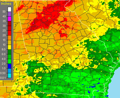
Here in Lawrenceville, I recorded 7.47 inches, in Gainesville, they had 11.2 inches or rain, with Macon and Columbus still top-ten wet, with 6.37 and 6.39 inches of precipitation, respectively. Even more of an eye-opener is the two month totals for September and October, shown graphically below:

September-October, 2009 Georgia rainfall

The two month period saw 17.65 inches of rain fall in Atlanta, second only to 1888, when 18.25 inches fell. Both Athens and Macon had their wettest September and October ever, with 19 inches in Athens and 17.05 inches of rain in Macon. Columbus had it’s third wettest September-October with 11.69 inches, and in Lawrenceville, which received some of the heaviest rainfall in the September flooding, I recorded 23.3 inches for the period.

Usually heavy late-summer rain is brought about via tropical storms or hurricanes affecting Georgia, but not this year. (This season has had the least tropical activity since 1997, with one month to go before it ends). And of course the one benefit to all the rain is that it returned Lake Lanier to full pool, marking a recovery from the drought.

October also proved to be cooler than normal for North Georgia. Atlanta’s average temperature of 61 degrees was 1.9 degrees cooler than normal, while in Athens, the average of 60.7 degrees was 1.1 degree less than normal. Here in Lawrenceville, I recorded an average of 59 degrees, cooler still.

It looks like we’ll have a chance to dry out during the first two weeks of November, though, and perhaps see temperatures a bit warmer than normal for mid-Autumn. The short term forecast is for dry weather, while the 6-10 and 8-14 day forecasts are also calling for warm and dry. For the month as a whole, the Climate Prediction center calls for a 33% chance of drier than normal conditions, and equal chances of above or below normal temperatures.

Enjoy November, because the winter forecasts from December through February I’ve seen are almost unanimous in their call for a cold, wet winter.

Sphere: Related Content

Share

September 2009 North Georgia Weather Recap

Sunday, October 4th, 2009

September 2009 Georgia Rainfall
Now that September is over, we can look back at a month that will be remembered for plenty of rain. Of course, it all depended on where you were: Gwinnett, Cobb and Douglas counties received far more precipitation than did the official measuring station at Hartsfield Airport. Still, it was the fifth wettest September on record in Atlanta, with 8.94 inches, or 219% of normal. It was the third wettest September in Macon with 10.68 inches, or 328% of normal, and the fourth wettest in Athens, with 9.86 inches, or 279% of normal rainfall.

At my house in Lawrenceville, I recorded 16.28 inches of rain, or 427% of normal rain. Gainesville reported 12.10 inches of rain, or 275% of normal, and Peachtree DeKalb airport had 15.74 inches of precipitation, or 420% of normal. The image above graphically displays the month’s rainfall. Click on it to enlarge.

Cooler than normal temperatures early in the month were balanced out with warmer than normal temperatures later on, ending up with a more or less normal average temperature for September. Atlanta’s mean temperature was 73.4 degrees, two tenths of a degree above normal. In Gainesville, the average of 71.0 degrees was 0.7 degrees cooler than normal, and in Athens, temperatures were half a degree above normal, with 73.1.

By now, even the most cynical will have to admit that the drought that plagued Georgia from 2006-2008 is finally over. A recent study by Columbia University indicated the drought wasn’t caused by global warming, and in fact wasn’t that unusual. The study says that the drought appeared more serious this time because of the Atlanta region’s growing population. While there was enough water for the region during similar droughts in the 1950s, not enough additional water storage was available to meet needs this time.

Sphere: Related Content

Share

Rain, Rain Go Away

Thursday, September 17th, 2009

Much of the southeast US has been caught up in a blocking pattern over the past few days, with an upper level low pressure system stuck over the Mississippi/Louisiana area causing wet, tropical air to be brought up from the Gulf of Mexico. While there’s no tropical storm bringing in all this precipitation, the effects are much the same.

In fact, the three day total rainfall I’ve recorded at my home of 4.45 inches is the largest three day total since exactly five years ago on September 16-17, 2004, when 4.73 inches of rain fell as the remnants of Hurricane Ivan came through the state. And it’s possible that we’ll get even more rain later today to beat that record.

Rainfall amounts are varying widely across north Georgia. While I don’t yet have official readings for today, yesterday, Atlanta recorded .76 inches of rain, while I received 2.23 inches. Other areas with a lot of rain yesterday include Chamblee with 1.99 inches and Charlie Brown field with 1.16 inches.

Unfortunately, the rain is going to stick around through the weekend and possibly into the first part of next week before we get to a dry spell. With the ground already saturated from rain, much of Georgia from the Atlanta metro area south has been placed in a flood watch until Saturday morning. As of now, there are no reports of flooding, but it’s certainly possible.

Sphere: Related Content

Share

July Was Cooler Than Normal for Much of the Country

Wednesday, August 5th, 2009

July ended up being cooler than normal for the northern and eastern parts of the US, in some cases setting records or near records for the cold weather.

In Atlanta, the average temperature of 78.1 was 1.9 degrees cooler than normal, and cooler than it was in June, when the average temperature was 79.8 degrees, or three degrees above normal. July’s colder than normal temperatures were helped out by low humidity and much colder than normal lows from the 18th through the 21st, with two record low temperatures set during that time.

Atlanta was not the only location to have a colder than normal July. In New York City, the average temperature of 72.7 was 3.8 degrees below normal, continuing a trend that began earlier in the spring. With a high temperature of 84 degrees in June and 86 in July, this was the second time New York weather failed to reach 90 degrees in June or July. The other time was in 1996.

Other cities with colder than normal temperatures in July include Chicago, whose average temperature of 71.0 degrees was 4.5 degrees colder than normal; Cincinnati, with a 70.9, 5.9 degrees colder than normal and Kansas City, Missouri, with an average of 75.4, 3.1 degrees colder than normal.

The heat did show up in much of Texas. In Houston, the average temperature of 86.7 was 3.1 degrees warmer then normal, and in Austin, the average of 89 was 4.8 degrees warmer than normal.

Rainfall in Georgia seemed to be concentrated in the western part of the state. Atlanta ended up with 5.02 inches of July rain, just slightly less than normal. However in Lawrenceville, I only received 3.48 inches, most of it on the last few days of the month. In Athens, only 1.33 inches of precipitation fell, which was 30% of normal July rainfall.
(more…)

Sphere: Related Content

Share