Get Forecast For:
Lawrenceville Weather

Archive for the ‘Tropics 2009’ Category

Ida Brings Minor Flooding to Metro Atlanta

Tuesday, November 10th, 2009

Despite threats of 4-5 inches of rain along the I-85 corridor due to the remnants of Hurricane Ida, it appears that most of the Atlanta area only received in the neighborhood of 2-3 inches of precipitation. Here in Lawrenceville, I’ve recorded 1.87 inches since the rain started early this morning. In Alpharetta, they recorded 3.11 inches, and in Johns Creek, the Atlanta Athletic Club measured 2.98 inches.

Other Georgia locations received much more rain. Pine Mountain was reporting 5.48 inches of rainfall today, while Columbus recorded 5.01 inches. These two areas seem to be the hardest hit, and from glancing at the radar this afternoon, it seems that Alabama got the most rain. Gainesville recorded 2.44 inches, while Marietta saw 2.77 inches. The official Atlanta rain gauge at Hartsfield Airport recorded 2.71 inches.

The rain did cause some area rivers to reach flood stage. Big Creek in Alpharetta is flooding, as is Pew Creek in Gwinnett County, Peachtree Creek in Atlanta, and the Nickajack Creek in Cobb county. Suwanee Creek is expected to experience minor flooding tomorrow morning.

There’s still more rain to come before Ida bids Georgia farewell (and her remnants cause problems in the Delmarva peninsula). But, looking at the radar now, it seems like the forecasters should have picked I-59 in Alabama as the worst hit area, rather then the I-85 corridor.

Sphere: Related Content

Share

Ida to Bring Rain to North Georgia

Sunday, November 8th, 2009

I hope you enjoyed the beautiful weather today, with highs eight degrees above normal. In fact, the last week is the first time we’ve gone seven days without any rain since the middle of August. That’s about to change.

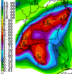
Rain Predictions Monday through WednesdayThe map to the right tells the story. A combination of a cold front, a low pressure system now over Texas, and Hurricane Ida will bring as much as four inches of rain to north Georgia beginning Monday night through Wednesday morning.
Much will depend on Ida’s exact path. While the official forecast from the Hurricane Center takes her path over extreme south Georgia, the GFS and Canadian models are much further north, passing over the Atlanta area. Over the past few forecast updates, the Hurricane Center has brought Ida’s path further north.

The Weather Service has issued a flash flood watch for much of North Georgia from Tuesday morning through Wednesday morning. Despite the lack of rain over the last week, the ground is still extremely wet, and any rain over two inches or so could trigger yet more flooding.

Sphere: Related Content

Share

Ida Rather Not Have More Rain

Thursday, November 5th, 2009

Excuse the punning, but it looks like Ida has formed in the southern Gulf of Mexico, and she could be heading our way. Ida became a tropical storm late Wednesday and has since hit land over Nicaragua and Honduras, reducing her intensity to a tropical depression.

Once she emerges over water, she is expected to return to tropical storm state, and her path is taking her north over the Gulf of Mexico towards the Florida panhandle. While nothing is certain (the storm wouldn’t make it to the US coast until next Wednesday at the earliest), there’s a possibility Georgia could see some tropical weather this year after all.

Sphere: Related Content

Share

Tropical Storm Danny Could Affect the East Coast

Wednesday, August 26th, 2009

This morning , the National Hurricane Center announced the formation of another tropical storm. Danny is the fourth tropical event of the season, and he looks to be roughly following the path of Hurricane Bill.

However, Danny isn’t expected to be as powerful as Bill was, and he is more likely to interact with the regular weather systems over the United States, especially a trough that is expected to develop over the Great Lakes. As a result, there is a little more uncertainty in the storm’s path. While the current official forecast keeps Danny to the east of the US east coast, the Canadian model puts the storm over the Outer Banks of North Carolina, and then along the east coast through the New Jersey Shore, and then north over land. Either way the Georgia coast is likely in the clear.

As a result, this could be the second interesting weekend in a row for the Northeast US. Stay tuned.

Sphere: Related Content

Share

Hurricane Bill Now a Powerful Storm

Wednesday, August 19th, 2009

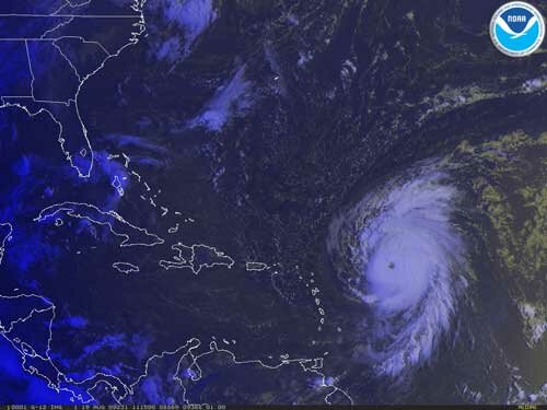
Hurricane Bill became a powerful Category 4 hurricane this morning, with winds estimated to be at 135 MPH, and the barometric pressure estimated to be 28.05 inches. The storm was moving west-northwest at 18 MPH.

Forecasters expect Bill to continue to strengthen somewhat over the next three days. Then, he will interact with a low pressure system coming east across the US. This will cause a northward turn, and at this point anyway, the storm is expected to recurve east without hitting the US coast. Vacationers and residents along the southeast coast will probably feel Bill’s effects with stronger waves and winds than normal.

NOAA satellites have been keeping an eye on Bill’s progress, and today, they released an animated series of images showing Bill’s progress between around 7:15 this morning and 12:15 this afternoon. Click on the still image below to bring up the animation in a new window. Fortunately Bill is passing north and east of the Caribbean islands – they’ll get some wind, but not the storm they would see if the storm were to the west.

Hurricane Bill

Sphere: Related Content

Share