Get Forecast For:
Lawrenceville Weather

September 2009 North Georgia Weather Recap

Sunday, October 4th, 2009

September 2009 Georgia Rainfall
Now that September is over, we can look back at a month that will be remembered for plenty of rain. Of course, it all depended on where you were: Gwinnett, Cobb and Douglas counties received far more precipitation than did the official measuring station at Hartsfield Airport. Still, it was the fifth wettest September on record in Atlanta, with 8.94 inches, or 219% of normal. It was the third wettest September in Macon with 10.68 inches, or 328% of normal, and the fourth wettest in Athens, with 9.86 inches, or 279% of normal rainfall.

At my house in Lawrenceville, I recorded 16.28 inches of rain, or 427% of normal rain. Gainesville reported 12.10 inches of rain, or 275% of normal, and Peachtree DeKalb airport had 15.74 inches of precipitation, or 420% of normal. The image above graphically displays the month’s rainfall. Click on it to enlarge.

Cooler than normal temperatures early in the month were balanced out with warmer than normal temperatures later on, ending up with a more or less normal average temperature for September. Atlanta’s mean temperature was 73.4 degrees, two tenths of a degree above normal. In Gainesville, the average of 71.0 degrees was 0.7 degrees cooler than normal, and in Athens, temperatures were half a degree above normal, with 73.1.

By now, even the most cynical will have to admit that the drought that plagued Georgia from 2006-2008 is finally over. A recent study by Columbia University indicated the drought wasn’t caused by global warming, and in fact wasn’t that unusual. The study says that the drought appeared more serious this time because of the Atlanta region’s growing population. While there was enough water for the region during similar droughts in the 1950s, not enough additional water storage was available to meet needs this time.

Sphere: Related Content

Share

April, So Far, Is Cooler than Normal

Thursday, April 16th, 2009

You may have noticed that it’s been a bit cooler than normal so far this April. As of this afternoon, the mean temperature for the month at Hartsfield Airport is 56.3 degrees, which is 3.6 degrees less than normal. Here in Lawrenceville, the mean is 56.4 degrees, not varying by much. Except on March 9th and 10th–when it barely made 80, we haven’t seen 80 degrees yet this year.

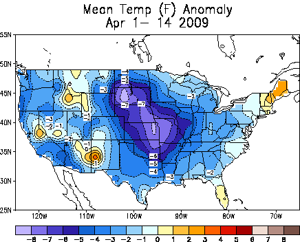
Normal temperatures for April 16th are a high of 73 and a low of 50. For the past few days, the highs have been in the mid-60s, with lows in the 40s. Much of the country has had a cooler than normal April, as you can see from the map below, which shows departure from normal temperatures for the first fourteen days of April:

Temperature Anomaly Map April 1-14, 2009

It looks like we’ll have one more week of cool temperatures, before we start seeing 80 degrees by the end of next week. If you’re a fan of spring flowers like me, the positive side to the cool weather is that mother nature’s show lasts longer than normal. I remember in years past when a warm spell in late March brought out everything at once, and it was gone in a week. Not this year.

Today, the Climate Prediction Center updated its long-term outlooks for drought, May and the early part of the summer. North Georgia has mostly recovered from the drought, with only five percent of the state in moderate drought, and another two percent abnormally dry. The dry area includes the northeast portion of the state, but not metro Atlanta. Compare this to a year ago, when 54% of Georgia was experiencing drought conditions. Lake Lanier continues to improve as well, measuring 1062.76 feet above sea level, or over a foot above where it was a week ago.

The drought outlook through July show no signs of drought redeveloping, and calls for improvement in the corner of the state where drought still exists. The precipitation outlook, both for May and for May through July calls for equal chances of above or below normal rainfall for most of the United States. Above normal precipitation is likely for Minnesota and the Dakotas, while it is likely to be drier than normal in Utah and Idaho.

The temperature outlook for May and for May-July calls for equal chances of above or below normal temperatures east of the Mississippi, with warmer than normal weather in most of the southwest, and cooler temperatures in the same Minnesota-Dakotas area that is going to be wetter than normal.

The Climate Predication Center notes that we are entering a neutral period, neither in El Nino nor in La Nina sea surface temperatures. With neutral conditions, there are fewer reliable signals of what weather conditions will be, compared to either a La Nina or El Nino state.

Sphere: Related Content

Share

March Rains Largely End North Georgia’s Drought

Monday, March 30th, 2009

Widespread March rainfall has caused all but a few North Georgia counties to become drought free. According to information from Georgia Climatologist David Stooksbury, the only counties still considered to be in moderate drought are Union, Towns, Rabun, Lumpkin, White, Habersham, Hall and Stephens. A few northwest Georgia counties are drought free, while the remainder, including Gwinnett, are classified as abnormally dry, mostly due to the long-term rain deficit we’ve experienced for the past four years.

Atlanta has recorded 7.12 inches of rain in March, over two inches more than normal. For the year, the deficit is 1.09 inches. With 7.03 inches of March rain in Athens, the Classic City is only .39 inches below normal for the year. With an additional inch or so expected Tuesday through Thursday, both cities could be back to normal rainfall by the end of the week.

While the plentiful precipitation seems to have encouraged Atlanta area flora to show their spring colors more strongly than in recent years, the hidden subtext of the drought picture, which I assume will be reflected in Thursday’s drought monitor, is that the counties that make up Lake Lanier’s drainage basin, including Hall and Habersham, are still in a moderate drought. Last week’s rainfall raised Lanier’s level by over a foot, but the lake is still ten feet below full summer pool.

The current climate pattern of a weak La Nina transitioning to neutral is responsible for much of the changes to a wetter spring. According to Stooksbury:

Currently the climate pattern is a weak La Niña pattern tending toward a neutral pattern. A typical weak La Niña spring brings wet weather across the northern piedmont into the mountains, just like north Georgia experienced in March.

Moisture conditions are in good shape across most of the state’s northern half, but the typical moisture recharge period will be ending soon. By the middle of April, plants are in full spring growth and using tremendous amounts of water.

By the middle of April we can expect the soils to begin to dry because of increased plant water use. Additionally, by the middle of April, temperatures are routinely in the 70s to low 80s. This means that evaporation will increase. This late spring and summer drying is normal.

The outlook is for a few more weeks of recharge followed by the normal drying of the soils due to plant water use and evaporation. May is usually a dry month. Little recharge is expected from May through October, but this is typical for Georgia.

The big unknown is what the tropics will bring Georgia this summer and winter. Much of the state’s late summer and fall rain comes from tropical disturbances. Without moisture from the tropics, August through October can be very dry. At this time there are no clear indications of how much rainfall the summer will bring.

Sphere: Related Content

Share

Another Blast of Cold for Next Week; and a Watering/Drought Update

Tuesday, March 10th, 2009

Temperatures over the last few days have been 10 to 15 degrees above normal for this time of year. In the ‘typical’ early March, we’d be seeing a high of 63 and a low of 42. Things are about to switch around closer to normal, and then below normal for next week.

High pressure centered over south Georgia has provided the warm temperatures, and has blocked the colder temperatures and storms to the north from moving south. As the high pressure weakens on Wednesday, a cold front will sweep through, and by Thursday, temperatures will be noticeably cooler. By the weekend, wedging sets up, which will bring cloudy, cool damp weather to Atlanta and North Georgia.

All of this may clear out with a cold front coming through on Sunday, and after that, one more round of cold weather, with temperatures dropping below freezing after St. Patrick’s Day. It’s too early to know how cold it will get, but I hope you took my advice from last week to not put out any annuals. Both the 6-10 and 8-14 day forecasts call for colder than normal temperatures for much of the eastern US, and wetter than normal conditions for the southeast, especially early in the period.

Will next week’s cold weather be the last blast of Winter? In 2008, the last below freezing night was on March 25th, but in 2007, a late freeze in early April ruined the spring flower show.

Drought Update

Last week, the Georgia EPD announced that drought watering restrictions had been further reduced. Homeowners and businesses will now be allowed to use soaker hoses or drip irrigation three days per week for one hour per day, following the customary odd-even, midnight to 10 AM schedule previously used for hand watering. Hand watering will continue to be allowed for 25 minutes per day on the odd-even schedule.

The state’s intent here is to provide a means for homeowners to water shrubs and trees, rather than lawns. In face, lawns are specifically excluded from the EPD’s order (PDF). The interesting thing is that there’s no limit to the amount of soaker hose or drip irrigation that can be used – only a limit on the number of hours the system can run. The recommendation is that each soaker hose should be no more than 100 feet long, but by investing in a few of them, and possibly some faucet Ys, even someone with lots of landscape plants should be able to better this year than last.

Sphere: Related Content

Share

Georgia Drought Loosens its Grip as Snow Falls in Las Vegas

Thursday, December 18th, 2008

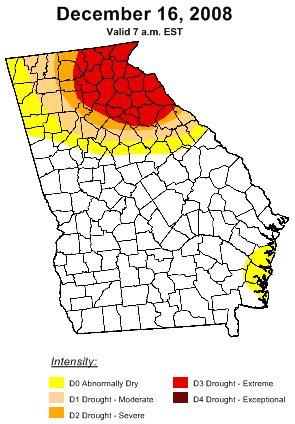
Georgia Drought as of December 16, 2008Last week’s rainfall greatly reduced the intensity of the drought in Georgia, according to the latest update to the drought monitor, shown at right. Before last week’s rain, exceptional drought was the rule north and east of Gwinnett County, some 11% of the state. This week, no part of Georgia is in exceptional drought, and almost 70% of the state is drought free.

Only a small area of the state between Savannah and Brunswick increased in its rain deficit, going from normal to exceptionally dry. The newest outlook through March, 2009 calls for continued improvement for drought conditions in the southeast, and for drought to develop in the Florida peninsula and extend in Texas.

The updated drought outlook doesn’t square well with the latest long range outlooks from the Climate Prediction Center, released this morning. The temperature outlook for January is for warmer than normal east of the Rocky Mountains, except for South Georgia and Florida, which could be colder or warmer than normal. Below normal precipitation will occur south and east of a line from southern Louisiana to eastern North Carolina, more or less south of I-85.

For the first three months of the new year, warmer than normal temperatures are predicted east and south of a line from New Mexico to Wisconsin. Colder than normal temps are in line for the Pacific Northwest, with the Northeast possibly going either way. The three month rainfall outlook calls for above normal precipitation in the Ohio Valley, and below normal rain in the southeast.

(more…)

Sphere: Related Content

Share