Get Forecast For:
Lawrenceville Weather

Archive for the ‘Site News’ Category

Lawrenceville Weather Blog is on Facebook.

Friday, May 7th, 2010

Lawrenceville Weather has moved into the social media world. While it’s possible there may be some additional blog posts, comments on the weather will now be made through our Facebook page. Become a fan today!

Sphere: Related Content

Share

Get Weather on Your Mobile Phone

Thursday, November 20th, 2008

I’ve added a stripped down version of the LawrencevilleWeather.com home page and forecasts that you can easily access from your mobile phone when you’re on the go and want to know what’s happening with the weather.

The graphics light version should appear automatically if you’re using an IPhone, Ipod, TMobile G-1 (Android) and some others. You can go to lawrencevilleweather.com or, if you hate typing, you can go to lzuwx.com and get to the same place.

You’re not going to get all the big graphics that are available on the regular site, since they don’t size well to the smaller screen you have on your phone. But, you will get the forecast and warning information, and I’ll probably add some other pages that can be made phone-friendly.

If you see the regular site with the graphics and all on your mobile, let me know via a comment here, and I’ll see what I can do to get your phone supported.

Oh, and why lzuwx.com, besides the fact that it’s short? LZU is the abbreviation that airplane pilots and the FAA use for Lawrencevillle’s Briscoe Field, and WX is a common abbreviation for weather.

Sphere: Related Content

Share

Water Wars, Colder Weather, and Better Forecasts

Tuesday, October 21st, 2008

This is going to be one of those grab-bag posts. Sometimes I see things in the news that are weather related, but don’t post immediately about them.There have been a few things like that recently, so here goes.

We’ll start with the drought, and more specifically, the effects on the Atlanta water supply. As Lake Lanier remains at near record low levels, Georgia EPD Director Carol Couch has asked the Army Corps of Engineers to reduce discharges from the lake to create a flow of 650 CFS at Peachtree Creek on the Chattahoochee River. This is similar to a reduction made last spring which, Couch argues, didn’t cause any environmental damage, and would save some 11.7 billion gallons of water.

Meanwhile, Senator Obama has apparently decided that Florida is more important than Georgia, telling potential Sunshine State voters he would side with them when it comes to deciding who gets water from the Apalachicola Chattahoochee Flint river basin. This prompted a quick response from Senators Isakson and Chambliss expressing their disappointment with his comments. It’s another reason to think carefully before you decide to vote for the Chosen One.

(more…)

Sphere: Related Content

Share

New Features: Area Conditions, Tide Charts and River Stages

Sunday, October 12th, 2008

I’ve spent a busy weekend working on the site, and have made several improvements. The first is a change in the way that I get current conditions, which is now much faster than it was previously. As a result, the state conditions page (see here for Georgia) now comes up much faster. I’ve also added area conditions to the home page, and expect to add area conditions to other locations as time allows.

For Atlanta area residents, this won’t be a big deal, but I have now added high and low tide information for forecasts along the coast, such as Savannah. You can also start at the tides center, and drill down to see high and low tide charts for most US coastal areas.

The other new feature displays river flows and heights for many rivers and lakes across the country. Many people are interested in the water level at Lake Lanier. Of course, there a gabillion river gauges, so you can start here to see where flooding might be occurring or to drill down to gauges in your area.

I’m going to be working on providing both short term (3-6 hour) and long term (8-15 day) forecasts in the near future, so you might see some changes to the way the forecasts look as I experiment with them.

Sphere: Related Content

Share

Tropical Invests Support Added to LawrencevilleWeather.com

Thursday, October 4th, 2007

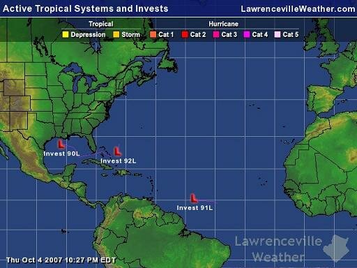
A while ago, I mentioned that I would be improving the capabilities of the Tropics section of the website. This has been continuing over the past few weeks, and as of this evening, I’ve added support for the display of Tropical Invests. As it so happens, there are a number of active invests right now, which you can see in this map of the Atlantic Tropical Basin, or in the map below, which isn’t live:

Tropical Invests

An invest is a low pressure system that hasn’t yet developed into a tropical depression, but is of interest, because it could. Think of it as a ‘storm of interest’ that the Hurricane Center is paying attention to to see if it will develop into anything. For example, Invest 90L is the system that’s brought the rain this week to North Georgia, but is unlikely to develop into a storm. However Invest 92L could well develop into a tropical storm or worse, depending on exactly where it goes.

You can view a map of an invest’s path, and you can also view what forecast models predict the storm’s path will be.

Sphere: Related Content

Share