Get Forecast For:
Lawrenceville Weather

Archive for the ‘Meteorology’ Category

Winter Returns (Or Perhaps It Never Left)

Monday, February 25th, 2008

I hope everybody had a chance to get out and enjoy the great weather today. The high temperature was 7 degrees above normal, and the abundant sunshine was a welcome change from what we’ve seen recently.  Unfortunately, today may have been the nicest day we’ll see until the weekend.

We are in an interesting weather pattern now, with what meteorologists would say is a ridge in the west, and a trough in the east.  In layman’s terms, think of it as a mountain of dense air in the western half of the country, and a valley of lighter air east of the Mississippi.  Now, imagine yourself as an air mass in the Pacific trying to move from west to east.  You encounter the air mountain, and are forced to move north to get around it.  As a result, you get colder.  Then, after passing the mountain, you find yourself drawn southward, into the valley of lower pressure air.

The result of this air movement is that the southeast gets a fast moving storm system as the air mass passes through.  Then, we get colder weather because of the temperature of the air that follows the storm.  Finally, things begin to warm up again due to the warmer angle of the sun.  Then, the pattern repeats itself, as it will do tomorrow morning, on Friday, and again next Tuesday.

All in all, it’s not that unusual a pattern for early spring. In some ways, it’s a good thing, since it indicates that the effects of the La Nina pattern are loosening, which could bring more rain to an area that sorely needs it.

Sphere: Related Content

Share

Developing La Nina Conditions Could Mean a Warm Dry Winter

Friday, September 7th, 2007

The Weather Service provided further confirmation to what it had been hinting at for the past several months yesterday, when it issued a news release reporting a developing La Nina condition. The expectation is that La Nina conditions will continue to develop over the next three months, and provide a wintertime La Nina weather pattern. This expectation is backed up not only by observation, but by computer modeling.

If La Nina conditions develop, what can we expect for this winter? According to statistics gathered during previous La Nina years, there is a 49% chance of less than normal precipitation in North Georgia from January through March, and a 60% chance that temperatures will be above normal. There’s only an 8 percent chance of below-normal temperatures, but there is still a 32% chance of above normal precipitation.

La Nina conditions occur when sea surface temperatures in the Pacific Ocean are below normal for more than three months in a row. It is the opposite of El Nino conditions, where equatorial ocean temperatures are above normal. The last time we had a La Nina episode was back in 2000.

Sphere: Related Content

Share

The Last Spring Freeze Date in North Georgia

Tuesday, March 20th, 2007

With Spring officially arriving tonight, and the weather warming up, it’s time to start thinking about planting outdoors. There are two weather-related things to keep in mind before you run out to the garden center to pick up those summer annuals.

The first is the last freeze date. You don’t want those newly planted flowers to freeze. For Georgia, the last frost date ranges from March 20th along a line from Columbus to Macon to Augusta to April 20th up in the mountains of Northeast Georgia near Clayton. According to the Weather Service, metro Atlanta to Athens has its last freeze sometime between March 30th and April 10th.

In reality, though, the last time Atlanta had a spring freeze in April was back in 2000, and before that, you have to go back to 1992. There have been a number of freezes in late March, however. In addition, Atlanta tends to be a bit warmer than the suburban counties, so the actual last freeze date would be a bit later here.

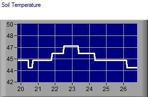
In addition to thinking about the last freeze, consider the soil temperature before you plant. Most annuals won’t grow much until the soil temperature remains above 60 degrees, and some plants, prefer temperatures above 70. I keep track of the soil temperature with a probe about 6 inches down in my backyard. A graph of the temperature is below:

The image above is live, and as I look at it, I see the soil temperature reached 56 degrees during last week’s warm spell, then dropped to 48 over the chilly weekend. It’s now on the way back up. So, as of today, it’s still too early to plant, even if you were positive we weren’t going to see any below 32 degree weather. When you see the temperature above 60 and staying there, that’s a pretty good indication that it’s safe to plant.

Sphere: Related Content

Share

Freezing Rain Wednesday Night?

Tuesday, January 16th, 2007

There’s a reasonable chance that metro Atlanta might get its first wintry weather Wednesday night and into Thursday, but the forecast is tricky, and a lot of what will happen will depend on exactly how conditions set up.

During the day Wednesday, North Georgia will be under control of a high pressure system located over Virginia. This will make for a chilly day again. Meanwhile, a low pressure system is moving east. It’s the same one that has brought freezing rain to Texas earlier this week. Whether we get a major winter event depends on how these two systems interact.

As the warm, moist air moves into Georgia, it will meet the colder air. Since the colder air is heavier than the warmer air, it will remain below the warm air. This effect is called Cold Air Damming, or popularly, ‘the wedge’. The possible effect is that instead of temperatures rising with the incoming rainfall, it will remain cold enough at the surface to cause sleet or freezing rain.

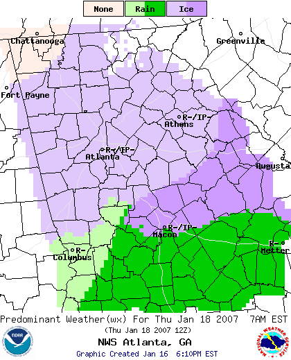
Below is the Weather Service graphical forecast for 7 AM on Thursday:

You can see that below Macon, there will be heavier precipitation, and it will be all rainfall. There’s an area north of that that may see heavier icing, since it will be in the more active part of the rainy sector, while also under the influence of the wedge. North of a line from Columbus to Athens, including Gwinnett County, freezing rain is also predicted.

So what happens on Thursday morning is a function of how strong a wedge develops, and how fast the precipitation moves. Since the ground is warm because of the springlike weather we saw before today, there isn’t likely to be any accumulation on the ground. However, if we do get freezing rain, it will affect trees and power lines, and things could turn nasty. If it’s too cold, we get sleet, which won’t be a problem. And, if the wedge is weak, we may get all rain as temperatures close to the surface remain above 32 degrees.

Stay tuned…

Sphere: Related Content

Share

What Are The Chances of a White Christmas?

Monday, December 18th, 2006

Well, in Georgia, not very much. But, if you’re in the Northwest United States, they are very good. Below is a map showing the probability of a white Christmas based on data from 1961 through 1990:

According to the folks at the NOAA National Data Centers, who put together the graphics, the chances of a white Christmas is greatest in Savannah and Brunswick, oddly enough, with a probability of under 5%. Elsewhere in the state, the chance of snow in virtually zero. The report (PDF) says that there are five places in the US that are virtually guaranteed of having one inch of snow on Christmas day, including Marquette and St. Ste. Marie, Michigan, Hibbing and International Falls, Minnesota, and Stampede Pass, Washington. You can also find out the probability of snow on Christmas for many other cities in the report.

Sphere: Related Content

Share