Get Forecast For:
Lawrenceville Weather

Above Normal Hurricane Season Predicted for 2009

Friday, December 12th, 2008

Earlier this week, the Dr. Gray and his team at Colorado State University issued their initial outlook for the 2009 hurricane season. The early outlook predicts a continuation of the above-normal tropical activity we’ve seen over the past few years. The outlook is for 14 storms, compared to over nine in a normal year, and seven hurricanes, compared to six in a normal year. There should be three major hurricanes, and there’s a 63% chance of a major hurricane making landfall somewhere in the United States–about 20% greater than in a normal year.

Last year at this time, CSU predicted there would be 13 named storms, seven hurricanes and three major hurricanes. The result ended up being 16 storms, eight hurricanes and five major hurricanes, so they underestimated. However, their new model for predicting hurricanes from this far out is apparently more accurate than the model they used previously.

A few other weather tidbits:

if tonight’s full moon seems brighter than usual, it’s because the moon is closer to the earth than it’s been for the past few years, and the first time in 15 years that the close approach, caused by the Moon’s elliptical orbit, has occurred during a full moon. Coincidentally, the moon is riding higher in the sky than any other full moon this year. The sun and moon follow opposite visual paths–when the sun is low close to the winter solstice, the moon is high in the sky, while in the summer, when the sun is overhead, the moon is low in the sky.

Another astronomical factoid — today is the first day that the sun begins to set later in the evening than it has since back on July 5th. Day will continue to shorten for another ten days, due to the sun rising later. We won’t get an earlier sunrise until January 13th.

The storm that brought welcome rain to much of the southeast is now history, having moved up the east coast and causing major power outages in the northeast. Much of Massachusetts was caught in an ice storm, with considerable damage. Albany, New York had .6 inches of ice, while Schenectady reported .88 inches of accumulated ice.

We are about to see a big pattern change in the weather across the United States. The past month or so has been dominated by an upper level trough in the east and a ridge in the west. This pattern brought warmer than normal conditions to the west, and colder than normal weather to the east, as the jet stream dived south, following the path of the trough.

Now, a trough is developing in the west, which will bring colder than normal weather there, but more seasonable, if not warmer than normal weather to the Southeast. There’s a better than normal chance of above normal temperatures for most of the south through Christmas, and it looks like we’ll get some additional rainfall, too. Lake Lanier’s current level is 1051.88 feet–more than ten inches above where it was on Wednesday before it started to rain. The AJC reports that yesterday was the first day since the record low level last December that the lake level in 2008 was higher than it was on the same day in 2007.

Sphere: Related Content

Share

First Winter Storm Clobbers Midwest, Northeast US

Sunday, December 2nd, 2007

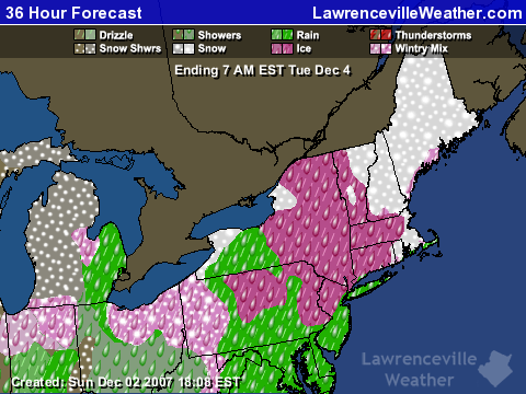
The first major winter storm of the season struck the northern third of the nation over the weekend, bringing an  ugly combination of snow, freezing rain, and rain to everywhere from Washington State to New York as a low pressure system combined with cold arctic air moved across the country.  Portions of Michigan reported up to ten inches of snow and 1/8th inch of ice from freezing rain this morning, and depending on where you were in Pennsylvania, you got from one to ten inches of snow.

Now, the storm is bearing down on New England, as you can see from the forecast map below:

360 hour weather forecast for New England

The precipitation is made  much more treacherous because the freezing line runs right through the area the storm is hitting in Pennsylvania and southern New England.  The northeast is going to get a one two punch.  After the current storm moves out Monday night, a second clipper will track across the area on Wednesday.

Here in Georgia, we’ll be lucky to get half an inch of precipitation as the cold front associated with the low crosses the state overnight Sunday.  Following that, we’ll have some cooler temperatures this week before a warmup the week of the 10th, when temperatures will again rise to the mid 60s.. Don’t expect much rain during this period, though.  After tonight, we may not see rain until the second half of December.

Sphere: Related Content

Share

Gwinnett Under Ice Storm Warning

Thursday, December 15th, 2005

In what could be the first of three pre-Christmas winter events, Gwinnett County is waking up this morning to an ice storm. Originally predicted to stay north of our area, temperatures dropped enough prior to the onset of rain to create a hazardous situation once the rain began to fall.

The Weather Service gave up shortly after midnight and issued a winter storm warning for Gwinnett County and Northeast Georgia until 6 PM on Thursday. Peering outside, light ice has formed on the trees. Several areas are without power, including parts of Lilburn and Duluth, although the situation so far doesn’t seem too serious.

Here, temperatures dropped as low as 30.9 degrees around 1 AM before starting to rise slightly, although the thermometer hasn’t gone above the present 32.5 degrees. Once day breaks, the question is how fast and far the temperatures will go up. For areas to the south and west, we’re likely to see above freezing temperatures after sunrise. North and east may see temperatures hover in the 32 degree range until afternoon. Both areas will see up to a quarter of an inch of precipitation before things slow down this afternoon.

Forecasters were slightly caught by surprise this morning by the extent of the cold weather’s reach. Atlanta is on the edge of two frontal systems – a high pressure system centered over New England bringing in cold, dry air in from the east, and a low pressure system bringing in the rain from the southwest. This mixture caused a wedge of cold air to get stuck over the north Georgia mountains. Yesterday was expected to make it into the low 40s in northeast Atlanta, with temperatures staying above the freezing mark overnight.

Instead, the wedge was stronger than expected, reaching farther south. the temperature here hit a high of 38 degrees shortly after noon before beginning to fall slightly. By the time the rain arrived in the early evening, the thermometer began to drop even more as dewpoints began to rise.

Even if we manage to dodge the bullet today, there are two more chances of winter weather in the next week – on Sunday, and again on Tuesday or Wednesday. I’ll post more on these possibilities later.

Sphere: Related Content

Share

One of the Most Significant Ice Storms since 2000

Saturday, January 29th, 2005

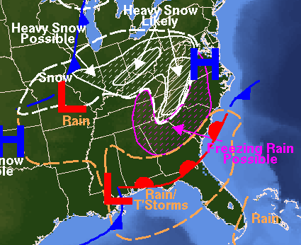
That’s what the forecaster at the National Weather Service called this weekend’s weather in North Georgia. After a brief round of sleet around sunset, the second wave of wet weather arrived in mid evening as far south as Americus, and moved northward, with significant icing across much of North Georgia.

Temperatures continued to drop as the wet weather arrived, caused by evaporational cooling. In metro Atlanta, temps were in the mid 20s at 5 AM, with freezing weather as far south as middle Georgia. At this point, temps are not expected to go above freezing until sometime Sunday morning. Freezing rain, and possibly some snow will continue throughout the period, with the heaviest icing in the metro Atlanta area. After 7 PM, the chance of freezing rain drops overnight.

The winter storm warning remains in effect until 4 PM. Travel isn’t recommended, with I-85 closed in the Hamilton Mill area. Looking out my window, I can see what looks to be about a quarter inch of snow/sleet on the ground, not only in grassy areas, but also on the street. I’ll try to get out once it gets light to get some pictures. Some folks have posted their experiences from earlier last evening in the ‘comments’ area of the post below. Please tell us what you see using the Comments link.


The National Weather Service forecast map for today shows the wide-ranging effects of the storm. While we’re getting freezing rain, heavy snow is possible in an boomerang shaped area from eastern Illinois, to West Virginia, and on south through eastern Tennessee. The freezing rain will move up through North Carolina and Virginia.

Sphere: Related Content

Share