Get Forecast For:
Lawrenceville Weather

Archive for the ‘Musings’ Category

Recapping the Georgia 2009 Flood

Friday, September 25th, 2009

Weather-wise, the rainfall that caused the record-breaking flooding in metro Atlanta is now over. Of course, it’s going to take a while for roads to be rebuilt, and damage to homes to be repaired, but the last few days of dry weather has allowed river levels to recede and land to dry out.

The US Geological Survey declared the flooding a 500 year flood, according to an article in the AJC. Basing their data on river flow gauges, the USGS said there is only a 1/2 of one percent chance of a flood of the magnitude we saw this week. That doesn’t mean it will be another 500 years before we see this much rain, it’s just that the odds are very slim.

The weather service reports nine record river flows in the area, including Suwanee Creek cresting at 14.3 feet, more than two feet above the previous record. Additionally there were five top 5 record flows at other river gauges. Lake Lanier rose by about three feet due to all the rain.

Here are some rainfall totals from Monday, September 14th at 8 AM through Tuesday, September 22nd at 8 AM:
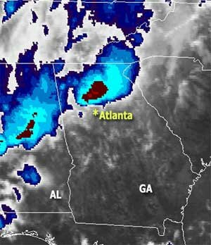
Satellite image taken Monday morning, September 21. Blues and Reds show the location of the heaviest rainfall when the image was taken.

Satellite image taken Monday morning, September 21. Blues and Reds show the location of the heaviest rainfall when the image was taken.


Kennesaw: 20.37 inches
Lawrenceville: 19.32 inches
Marietta: 18.91 inches
Douglasville: 18.18 inches
Tucker: 18.08 inches
Kennesaw: 17.6 inches
Canton: 17.14 inches
Snellville: 17.13 inches
Roswell: 15.49 inches
Doraville: 13.88 inches
Chamblee: 13.19 inches
Johns Creek: 13.16 inches
Dunwoody: 12.37 inches
Atlanta Hartsfield: 11.23 in.
Gainesville: 10.27 inches
Athens: 8.72 inches

You can see the full list as reported by the weather service and cooperative stations here.

One of the major causes of all the rain was a low pressure system west of Georgia being blocked by a high pressure system to our north. Even after the storms passed, the blocking pattern remained, which caused the continuing high humidity and 10 degree above average low temperatures over the past few days. This weekend, a cold front will finally push the whole system away, and give us cooler temperatures with low humidity, and a chance to dry out wet crawl spaces.

Sphere: Related Content

Share

Tornadoes Strike Georgia

Thursday, February 19th, 2009

Georgia saw its first severe weather of 2009 on Wednesday evening, with reports of tornadoes and severe thunderstorms causing one death and multiple injuries. It appears that most of the damage was recorded south of Atlanta, and along the Georgia-Florida border.

Preliminary storm reports showed an EF0 tornado in Warner Robins, an EF4 tornado in Washington, in Wilkes county, which traveled 16 miles and moved a two ton truck 60 feet, an EF1 tornado in Eatonton causing one injury, additional reports of EF1 tornadoes in Jasper and Newton counties, an EF2 tornado near Moreland in Coweta County, and an EF3 tornado near Sparta in Hancock County, which caused the fatality as its 140 MPH winds traveled an eight mile path.

Here is the preliminary report from the Weather Service as of late this afternoon:

TAYLOR COUNTY…THE TORNADO BEGAN NEAR TOMMY PRUVIS ROAD AND SB EUBANKS DRIVE AT 545 PM. THE INTERMITTENT TOUCHDOWNS WAS 3 TO 4 MILES LONG AND 50 TO 100 FEET WIDE. SEVERAL TREES BLOWN DOWN…A MOBILE HOME DAMAGED AND ONE BLOWN OFF ITS FOUNDATION. IT WAS RATED AS AN EF0 WITH WIND AROUND 70 MPH.

JASPER COUNTY…THE TORNADO TOUCHDOWN WAS AT 800 PM… APPROXIMATELY 7 MILES IN LENGTH…STARTING 9 MILES WNW OF SHADY DALE TO 2 WNW OF SHADY DALE…LIFTING ABOUT 810 PM. IT WAS RATED A WEAK EF1 WITH WIND ESTIMATED AT 100MPH. MINOR DAMAGE WAS REPORTED TO FIVE HOMES AND MAJOR DAMAGE TO A SMALL COTTAGE.

COWETA COUNTY…THE TORNADO TOUCHDOWN AT 923 BRADBERRY ROAD…APPROXIMATELY THREE MILES WEST OF HIGHWAY 27. THE STORM CONTINUED TO THE EAST-NORTHEAST ABOUT SEVEN MILES ACROSS SOUTHERN COWETA COUNTY…AND 1 MILE WIDE AT THE WIDEST POINT. THE TIME OF THE TOUCHDOWN WAS 830 PM… AND RATED AS AN EF2. AT LEAST A DOZEN HOMES DAMAGED ..SOME SUBSTANTIAL.

PUTNAM COUNTY…THE STARTING POINT WAS 7 WSW OF EATONTON AROUND 715 PM AND EXTENDED ABOUT 7 MILES IN LENGTH AND ONE QUARTER MILE WIDE. THE EF2 TORNADO UPROOTED NUMEROUS TREES…DOWNED POWER LINES CLOSED U.S. HIGHWAY 129…AND AT LEAST ONE PERSON INJURED FROM DEBRIS AS THE STORM WENT FROM WILLARD TO EASTONTON AND BRIEFLY TRAPPING OTHERS IN THE HOME OR CAR. A RESTAURANT COMPLETELY DESTROYED…AND SEVERAL HOMES SUSTAINED MODERATE TO MAJOR DAMAGE.

WILKES COUNTY…THE STORM REACHED THE WESTERN PART OF THE COMMUNITY OF TYRONE…NEAR HIGHWAY 44 AT 710 PM AND EXTENDED FOR 16 MILES IN LENGTH AND ONE HALF MILE WIDE. THE STORM WAS RATED AN EF4 WITH DEBRIS FROM THE DEMOLISHED HOME BEING CARRIED AT LEAST ONE HALF MILE. THERE WERE FIVE OTHER BUILDINGS RECEIVING MINOR TO MODERATE DAMAGE…AND A CHICKEN HOUSE WAS DESTROYED AS WELL.

There were also numerous hail reports, with golf ball size hail reported in Walton County, and 1.75 inch hail in Henry, Coweta and Clayton Counties.

For the next few days, it’s going to be colder than normal, with highs only around 50 degrees and lows below freezing at least until Wednesday. This is likely to balance out an already warmer than normal February. As of yesterday, Hartsfield airport’s mean temperature was 2.7 degree above normal. At this time of year, our normal high should be 58 degrees, with lows around 38. However after this cold spell passes, the outlook is for warmer than usual temperatures through the first week in March.

Long range, the outlook for March issued today by the Weather Service says we should see equal chances of above or below normal temperatures and below normal rainfall, and for March through May the trend of variable temperatures and drier weather holds as well.

Sphere: Related Content

Share

More Rain in the Forecast With a Slight Chance of Snow

Wednesday, December 10th, 2008

North Georgia got plenty of rain today, and it looks like there’s more to come. As of 7:30 Wednesday, I’ve recorded 1.79 inches of rainfall, the most since October 8th, when another massive low pressure system rolled through Georgia and brought 2.31 inches of rainfall.

Other areas in the Peach state got even more.  Since 7 PM yesterday:

Alpharetta – 1.84 inches
Atlanta – 1.76 inches
Athens – 0.76 inches
Cartersville – 1.65 inches
Chamblee: 1.91 inches
Dunwoody: 2.07 inches
Gainesville: 1.5 inches
Macon – 2.25 inches (and record precipitation for December 10th)
Peachtree City – 2.2 inches
Rome – 1.65 inches

In addition to the rain, there was a tornado sighting today near Tallapoosa.  The weather service reported an F0 tornado early this morning 3 miles northeast of that location in Haralson County. Closer to Atlanta, flooding is forecast for the Big Creek in Alpharetta.

All the rain has been good news for Lake Lanier.  The latest reading has the lake level at 1051.17 inches, which is .18 of a foot, or about 2.2 inches higher than it was early this morning.  And, the rain is not over yet.  Overnight a second wave of wet weather will visit north Georgia, possibly doubling the amount of rain we’ve had already.

By tomorrow night, the upper low that has been responsible for much of the rain will move northeast of Atlanta, and the cold front associated with it will bring a chance of snow to the northwest part of the state. Because of the warmup due to the rain, it’s not expected to produce any accumulation and if there is any, it should be confined to the northwest corner of Georgia. Folks in Mississippi aren’t so lucky, though.  The weather service has issued a winter storm warning for much of eastern Mississippi, predicting 3-5 inches of snow. In Louisiana, half an inch is possible.

Sphere: Related Content

Share

Things We Haven’t Seen in a While

Saturday, October 4th, 2008

I almost hate to talk about it, in fear of creating a jinx, but it looks like the Atlanta area could get some rain starting late next week.  The last time we had any rainfall at all, either here or Atlanta Hartsfield was back on September 11th, when .01 inches was recorded.  That means we are at 23 days and counting without rain. Now, models are indicating a trough will begin to move from west to east, and could bring rain sometime Wednesday or Thursday.  It may not be one of these one hour wonders either.  Accuweather says that the rain will stick around through next weekend, bringing almost two inches by Columbus Day. The CPC extended outlook calls for above normal rainfall in the 6-10 day period and weather.com is less optimistic, with rain only on Wednesday or Thursday.

I did the annual fall aerating and overseeding for my fescue lawn two weeks ago, which means that I get a pass from the watering restrictions, and can turn on my irrigation system on the appropriate odd/evn schedule.  Even with watering, when I’ve dug a few holes to plant some new bulbs and shrubs, I’m amazed at how dry the ground is. The rain, if it comes, will be much appreciated.

Another thing we haven’t seen in a while is freezing temperatures.  While North Georgia typically doesn’t get its first frost until the second week of November, Michigan, Vermont and Maine are seening freezing temperatures over the next few days.  Nationwide, the lowest temperature this morning was 17 in Stonington, Michigan.  There’s a frost advisory tonight starting in Western Michigan and moving east through northen Ohio, much of northern Pennsylvania and southern New York.  And, snow has begun to fall in the Rocky Mountains, including areas of Utah and Colorado, where a few inches are predicted through tomorrow evening.

You can keep up with the approach of winter on our Winter Weather page.  It’s just a matter of time before we begin to feel winter’s effects here in Georgia.

Sphere: Related Content

Share

While I Was Gone…

Monday, September 29th, 2008

It’s been almost two weeks since I’ve posted… partially because of some well-deserved vacation, partially because, at least here in North Georgia, a fairly quiet weather pattern, and partially because of some other interesting events taking up my web time.

So, what did we miss. After a few weeks of quiet on the tropical front, last week brought Hurricane Kyle, which was notable in that in the first time in 17 years or so, a hurricane made landfall in Canada. Right now, Subtropical Storm Laura is on her way to England, apparently, bothering no one, really. And then there was the storm that didn’t get named despite showing some tropical characteristics—including an eye, but brought rain to the Carolinas and up into the Mid-Atlantic states.

During all this turmoil, weatherwise and otherwise, the Atlanta area stayed dry.  I’ve recorded less than 2/3 of an inch of rain this month, and the official rain gauge at Hartsfield airport shows 3/4 of an inch, with no meaningful precipitation since back on the 12th.  That’s about 3 inches less than a normal September, although one only has to go back to 2005 to find less, when we only had a quarter of an inch.  The final total could change, since there are some storms in the area tonight, but it’s highly likely that we’ll go through another month with below-normal rainfall.

Sphere: Related Content

Share