Random Weather Thoughts

Thursday, May 29th, 2008

A few things of interest to the weather community:

The first tropical storm of the season has developed in the Eastern Pacific Basin. Tropical Storm Alma is currently passing over Nicaragua in Central America, and is forecast to dissipate as she heads north towards the Yucatan peninsula. The Atlantic tropical season starts on Sunday.While some runs of the GFS model indicated some sort of storm developing in the Gulf of Mexico this weekend, it appears that it was either a false alarm, or the GFS was really picking up on Alma.

The drought continues to diminish somewhat. Last week, all of metro Atlanta dropped from the extreme drought category to simply severe. As of this week, only Stephens, Franklin, Hart and Elbert counties in northeast Georgia are in extreme drought conditions, and 27% of the state is in a severe drought, including most of the area covered by the level four drought conditions.

Meanwhile, the Georgia EPD further relaxed watering restrictions for golf courses, which previously had only been allowed to water their greens. As of today, the new order from state EPD chief Carol Couch says that fairways and tee boxes can be watered, however golf courses can use only 65% of the water they used in 2005 or 2006.

This is actually a good thing, since golf courses typically get their water from natural lakes or ponds rather than the municipal water systems, and they contribute to the economy both directly and indirectly.

It looks like the hot, humid days of summer may be upon us. Despite today’s cooler than normal weather, caused by cold air damming that kept the clouds around and the temperatures low, the weather service says highs will be in the upper 80s beginning Saturday and continuing all next week. In addition, dewpoints are going to stay in the 60s, meaning you’ll feel the humidity and the heat more than you have since last summer. Accuweather is predicting a high of 93 for Tuesday, which would be the first time this year we’ve broken 90.

Sphere: Related Content

Hottest Weather of the Summer This Week

Sunday, August 5th, 2007

Despite a relatively cool July —the mean July temperature was actually cooler than the mean June Temperature, both here in Lawrenceville and in Atlanta— it looks like August is going to be our hottest month of the year.

The short range, medium range, and long range forecasts are all calling for warmer than normal temperatures, and it looks like we may not get much rain to help out, at least until the middle of the month.

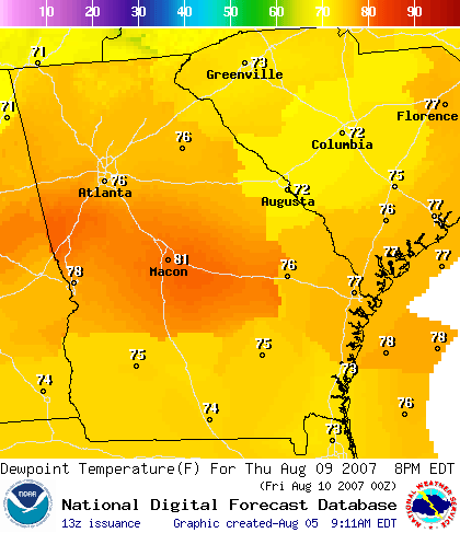
Temperatures will be approaching the 100 degree mark all this week in North Georgia. To make things worse, we’ll likely be seeing high dew points as well. That means that the humidity will be approaching the unbearable range. Take a look at the forecast dew points in Georgia for 2 PM Thursday:

If this forecast validates, we’ll see the heat index above 105 degrees, the danger level, several times this week.

Ultimately, it’s the moisture in the air that determines how we feel when we go outside. Although relative humidity is the measurement most people use to measure moisture content, the dew point temperature can provide a better measure of how uncomfortable conditions are. When the dew point rises to near 70 or above, most people are unlikely to want to be outside for very long.

The heat index also measures the apparent temperature. For more detail, take a look at this table showing the relationship between relative humidity, temperature, heat index, and dew point.

The reversal from the cool and wet July conditions to the hot and dry conditions for August isn’t going to do much to help the drought conditions in Georgia. Over the last month, the drought levels in Georgia haven’t changed very much. While the rain has kept lawns green in the short term, we will see a quick return to brown lawns without more rainfall.

As I’ve said before, tropical weather will probably be the key to breaking the drought. Despite the relatively quiet season so far, the latest forecast by Dr. Gray at Colorado State University is still calling for an above average hurricane season. The researchers are predicting 15 tropical storms for the season, down 2 from their May forecast, and eight hurricanes, down from nine in May. There’s also an above average chance of a major hurricane striking the US coast.

Sphere: Related Content

High Humidity Marks Summer’s Second Heat Wave

Sunday, August 21st, 2005

The dewpoint on Saturday measured 78.6 degrees late in the morning, which is the highest measured so far this year. With the temperature around 85 degrees at the time, the heat index felt like it was 95. By 2 PM, the temperature had risen to 92, and with the dew point still at 76, the heat index stood at 104.

That’s still not the highest heat index for the year, which was 106 on July 27th. On that day, we had the warmest temperature of the year, at 97, however the humidity was lower.

Look for one more day of unpleasantly hot and humid weather on Sunday before things begin to back off a bit going into the latter part of the week. While the cold front that could have brought a taste of fall will stay to our north, we’ll enjoy a few days with highs in the mid 80s.

The forecast for next weekend and into the beginning of the last week of August is for a chance of cooler than normal temperatures, and below normal precipitation. An extended forecast into Labor Day weekend calls for slightly above-normal temperatures, but still below normal rainfall.

Sphere: Related Content

Possible Heat Advisory for Sunday and Monday

Saturday, July 23rd, 2005

Gwinnett is preparing for some of the warmest weather of the season over the next few days, with heat indexes possibly rising to the point where the Weather Service will post an advisory for people to stay indoors.

Today’s high temperature of 92.9 here at my weather station marks the third straight day of above 90 degree temperatures. Fortunately, a front moving into the area from the north has lowered the dewpoint considerably from what we’ve seen in previous days. Today’s mid afternoon dewpoint was six degrees lower than it was at this time yesterday, meaning a heat index of 95 instead of yesterday’s 105, which is the high for the summer.

Sunday and Monday are likely to be warmer than today, and while the effects of the ridge will likely keep rain away, it will weaken, and give us higher humidity and more discomfort. By Thursday, we could see some thundershowers, and this wave of heat could be history by Friday.

While temperatures in the 90s are an expected part of life in Georgia, that isn’t the case for much of the rest of the country, which is also suffering from extreme heat. Here are some temperatures, measured close to 6 PM. The first number is the temperature, while the second is the heat index:

Memphis - 94 (108)
Carroll, Iowa - 97 (119)
Des Moines - 97 (113)
Ainsworth, Nebraska - 104 (101)
Kansas City - 98 (106)
Brookings, SD 97 (112)
St. Louis - 96 (117)
Boise - 89 (85)
Denver - 93 (89)

It’s interesting to note the fact that for the far west, the heat index is lower than the actual temperature. That’s because the relative humidity is in the teens. For example in Denver, the temperature is 93 and the dewpoint is 40, with 16 percent relative humidity.

Meanwhile, as far as tropical weather goes, Franklin seems to be heading into the Eastern Atlantic, and doesn’t appear to be a threat, although there is a chance it could curve west again, and threaten the Carolinas. Tropical Depression Seven has been declared in the Gulf of Mexico, and is likely to develop into tropical storm Gert before it makes landfall in central Mexico sometime Sunday night.

Sphere: Related Content