2008-2009 Winter Weather Forecasts for Georgia

Wednesday, October 29th, 2008

With winter just a month away from a meteorological perspective, it’s time to take a look at some of the forecasts that have been issued for a glimpse of what the season will bring.

We’ll start with the always interesting and sometimes reliable Old Farmer’s Almanac’s prediction for the southeast, which includes much of North Carolina, South Carolina and Georgia. Overall, they expect cold temperatures and normal to above normal precipitation, with more precipitation in the south. Look for above average snowfall, and the coldest weather in mid to late December, mid-January and mid-February.

On the other hand, Accuweather’s Joe Bastardi says to expect colder than normal weather for much of the east, with December being the coldest month relative to normal, a January thaw, and then cold again in February. The East can also expect more snow than last year.

WSB Radio forecaster Kirk Melhuish released his preliminary winter outlook this week, and it is similar to Accuweather, with ‘bookends’ cold spells at the beginning and end of the season, and less snowfall and slightly less rainfall than average. Kirk will issue his final winter forecast at the beginning of December.

Finally, what does the Weather Service say? They haven’t done a press release on their outlook as they have done in past years, so all you can do is look at their 3 month outlook for December-January. Unlike the other forecasts, the Climate Prediction Center thinks we have a better chance than normal for warmer weather. They also predict a 33% chance of drier weather, especially in mid and south Georgia.

(more…)

Sphere: Related Content

Spring Storm Brings Snow to Ohio, Pennsylvania

Sunday, March 9th, 2008

As predicted, the storm that started last week in Texas moved up the Ohio Valley on Saturday, bringing blowing snow over a foot deep in many places in Ohio, Indiana, Kentucky and Pennsylvania. The map below shows the depth of the snow as of 3 AM on Sunday, March 9th.

Midwest Snow Depth, March 9, 2008
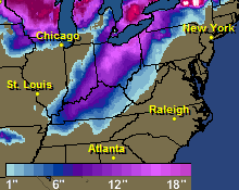
Here are some total snowfall amounts for the storm:

Aurora, Indiana: 12 inches
Florence, Kentucky: 15.5 inches
Louisville, Kentucky: 14.4 inches
Williamstown, Kentucky: 16 inches
Cincinnati, Ohio: 10 inches
Columbus, Ohio: 20.4 inches
Dayton, Ohio: 13.1 inches
Broadview Heights, Ohio (near Cleveland): 21 inches
Franklin, Pennsylvania (near Erie): 14 inches

Satellite Image of Snow

The satellite image above shows the effects of the snowfall.

Sphere: Related Content

Late Winter Storm Causing Havoc

Friday, March 7th, 2008

Much of the eastern half of the country is under the grips of a late winter storm that is bringing plenty of rain and snow to many areas.  Much of Ohio is under a blizzard warning, and a winter storm warning extends from southern Arkansas to Maine.  Earlier in the week, the storm brought snow to Texas, including six inches reported near Fort Worth and up to nine inches in the northern part of the state.

This system reminds me of the storm we had back on March 12-15, 1993 which brought half a foot of snow to the Atlanta area, and much more further north. Coincidentally, that was the weekend that Atlanta Motor Speedway held its Spring NASCAR race, the same as this weekend. While the worst effects of the storm will be further west than the 93 version, there is the same type of gulf-moisture driven low pressure that we saw back then.

The low is moving northeast, dragging gulf moisture with it.  More recently, much of Arkansas and Oklahoma received up to 14 inches of the white stuff, and further north, Indiana, Ohio and Kentucky have reported between 2 and 4 inches of snow, with more to come this evening as the front moves north.  Of course, the snow is on the cold side of the front.  On the warm side, temperatures stayed well above normal today, with a high here in Lawrenceville of 70 degrees.

(more…)

Sphere: Related Content

First Winter Storm Clobbers Midwest, Northeast US

Sunday, December 2nd, 2007

The first major winter storm of the season struck the northern third of the nation over the weekend, bringing an  ugly combination of snow, freezing rain, and rain to everywhere from Washington State to New York as a low pressure system combined with cold arctic air moved across the country.  Portions of Michigan reported up to ten inches of snow and 1/8th inch of ice from freezing rain this morning, and depending on where you were in Pennsylvania, you got from one to ten inches of snow.

Now, the storm is bearing down on New England, as you can see from the forecast map below:

360 hour weather forecast for New England

The precipitation is made  much more treacherous because the freezing line runs right through the area the storm is hitting in Pennsylvania and southern New England.  The northeast is going to get a one two punch.  After the current storm moves out Monday night, a second clipper will track across the area on Wednesday.

Here in Georgia, we’ll be lucky to get half an inch of precipitation as the cold front associated with the low crosses the state overnight Sunday.  Following that, we’ll have some cooler temperatures this week before a warmup the week of the 10th, when temperatures will again rise to the mid 60s.. Don’t expect much rain during this period, though.  After tonight, we may not see rain until the second half of December.

Sphere: Related Content

Spring Storms Show Nature’s Fury

Friday, March 2nd, 2007

We’re at the start of the big seasonal change from cold weather to warm, and the evidence is the powerful storm that damaged buildings yesterday in Alabama and Georgia. Even though we’re about a month away from the ‘heavy’ tornado season, the powerful temperature differentials that produce these storms can occur any time. The picture below shows a satellite image of the storm at about noon on March 1st:

Fortunately for North Georgia, there wasn’t any major damage, and the inch and a half of rainfall made some progress in denting the rainfall deficit. You would have to go back to the middle of November to find the last time we had that much rain on one day.

Winter will give us a reminder of its presence over the weekend, as temperatures Sunday night will drop below 30 degrees for the first time since President’s Day. The cold won’t last long, however, and you can look for warmer than normal temperatures through the middle of the month. March is one of the months with rapidly changing normals: the first of the month normally has a low of 38 and a high of 59; by the end of the month, our low is normally 46, and the high temperature has shot up by ten degrees to 69.

Although it’s not strictly weather related, be on the lookout tomorrow for a total eclipse of the moon. Totality occurs at 6:20 PM, and the moonrise in Lawrenceville is at 6:30 PM, just before sunset at 6:34. As the moon rises, it will be almost totally eclipsed, and will be partially eclipsed until about 8 PM. The forecast is for partly cloudy skies Saturday night, but with any luck, you’ll be able to see one of the two eclipses this year. The other one, in August, will only be visible in the early morning hours.

Sphere: Related Content