What a Difference a Storm Makes
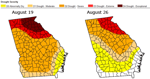
The two maps below show the tremendous difference a tropical system can make in dampening the effects of a drought. The map at left shows drought conditions in Georgia as of Tuesday, August 19th, when almost ten percent of the state was in exceptional drought conditions and only two percent was drought free. The right hand map shows conditions as of Tuesday morning the 26th at 7 AM. Now, none of the state is in exceptional drought, and 16% is drought free.

Remember, the cutoff for the drought maps was 7 AM Tuesday, which was before a good bit of the rain hit North Georgia, so I expect to see continued improvement with next week’s drought monitor as well. Lake Lanier has also risen just over two feet from the rainfall brought on by Fay.
The weather service has investigated the severe weather brought about by Fay, and has issued a report saying that there were six tornadoes in Georgia brought on by the storm. Most of the damage was in Hall and Jackson counties. Three EF1 tornadoes with 90 MPH winds were verified in Hall, where trees were knocked down and damage was reported to an elementary school.
Another tornado with 100 MPH winds touched down near Commerce in Jackson County, while two additional EF0 tornadoes with 70 MPH winds were reported in Monroe and Wilkes counties.
We may have some more opportunities for drought relief in the next week to 10 days. Gustav was a hurricane, and then was downgraded to a tropical storm when it made landfall in Haiti. It has moved a bit south, and is expected to increase in intensity to at least a category 3 hurricane. The media is comparing Gustav to Katrina, which hit New Orleans three years ago today. Despite the timing coincidence and the likelihood that Gustav will become an intense hurricane before it makes landfall sometime on Monday, it’s still too early to know exactly where the storm will make landfall. Recent updates to the forecast track have moved landfall west of New Orleans, and the further west it is, the less likely it will have any effect on the Atlanta area. A track further east, as some models are suggesting would make the storm more like Ivan in 2004, which brought intense rainfall to North Georgia.
And if Gustav isn’t enough, the Hurricane Center is now tracking Tropical Depression 8, located to the east of Puerto Rico. Later this afternoon, the storm will gain enough intensity to be named Hanna. Instead of moving south of Cuba as Fay and Gustav are doing, Hanna is likely to become a category 1 hurricane by Labor Day, moving north of the Dominican Republic and the Bahamas and heading west towards the Florida coast.
I suspect we’ll have a better idea of what both these storms will do as the weekend unfolds.
Sphere: Related Content
