NOAA Issues Spring Weather Outlook

March 21st, 2009

The Weather Service has issued its outlook for spring weather - April, May and June - although some would argue that especially in the South, spring runs from March through May. In any case, the next three months don’t show a trend one way or another for most of the Southeast US.
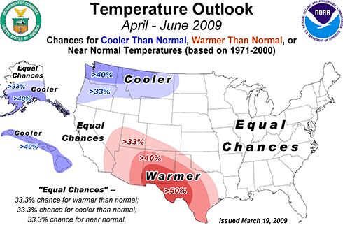
Spring 2009 Temperatures

East of the Mississippi River, there are equal chances of above or below normal temperatures. There’s a good chance of warmer than normal weather in the southwest, especially in Texas and New Mexico. The Northwest is expected to be cooler than normal, especially in Washington. Hawaii and parts of Alaska should be cooler than normal as well.
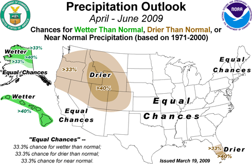
Spring 2009 precipitation outlook

Likely wetter than normal weather is expected in Alaska and Hawaii, while there should be less than normal precipitation in south Florida, the Rocky Mountains and the Pacific Northwest. The rest of the country has equal chances of above or below normal rainfall.

Because of all the snow this winter, there is a greater than normal chance of flooding in the upper Midwest, especially along the Red River Valley. There’s also a better than normal chance of flooding along the western Great Lakes region of Michigan and northern Illinois, Indiana and Ohio.

The overall weather is considered to be in an El Nino pattern, the warm cycle of Pacific Ocean sea surface temperatures. The El Nino pattern is expected to diminish to a neutral pattern later this spring, and in any case, its effects are less pronounced in the spring and summer months. In the southeast, where El Nino tends to bring drier than normal weather, you can see this in the outlook for April, which is likely to be drier then normal, compared to the April-June outlook, which could see above, normal or below normal rainfall.

In the short term, north Georgia could see a rainy stretch starting midweek, followed by a chance of freezing temperatures at night following more rain and the passage of a cold front next weekend. Until then, however, we’ll have pleasant late March weather, so get out and enjoy it.

Sphere: Related Content

  • Share/Save/Bookmark

Another Blast of Cold for Next Week; and a Watering/Drought Update

March 10th, 2009

Temperatures over the last few days have been 10 to 15 degrees above normal for this time of year. In the ‘typical’ early March, we’d be seeing a high of 63 and a low of 42. Things are about to switch around closer to normal, and then below normal for next week.

High pressure centered over south Georgia has provided the warm temperatures, and has blocked the colder temperatures and storms to the north from moving south. As the high pressure weakens on Wednesday, a cold front will sweep through, and by Thursday, temperatures will be noticeably cooler. By the weekend, wedging sets up, which will bring cloudy, cool damp weather to Atlanta and North Georgia.

All of this may clear out with a cold front coming through on Sunday, and after that, one more round of cold weather, with temperatures dropping below freezing after St. Patrick’s Day. It’s too early to know how cold it will get, but I hope you took my advice from last week to not put out any annuals. Both the 6-10 and 8-14 day forecasts call for colder than normal temperatures for much of the eastern US, and wetter than normal conditions for the southeast, especially early in the period.

Will next week’s cold weather be the last blast of Winter? In 2008, the last below freezing night was on March 25th, but in 2007, a late freeze in early April ruined the spring flower show.

Drought Update

Last week, the Georgia EPD announced that drought watering restrictions had been further reduced. Homeowners and businesses will now be allowed to use soaker hoses or drip irrigation three days per week for one hour per day, following the customary odd-even, midnight to 10 AM schedule previously used for hand watering. Hand watering will continue to be allowed for 25 minutes per day on the odd-even schedule.

The state’s intent here is to provide a means for homeowners to water shrubs and trees, rather than lawns. In face, lawns are specifically excluded from the EPD’s order (PDF). The interesting thing is that there’s no limit to the amount of soaker hose or drip irrigation that can be used - only a limit on the number of hours the system can run. The recommendation is that each soaker hose should be no more than 100 feet long, but by investing in a few of them, and possibly some faucet Ys, even someone with lots of landscape plants should be able to better this year than last.

Sphere: Related Content

  • Share/Save/Bookmark

Warm Weekend Weather Will Have Georgians Thinking Spring

March 3rd, 2009

I was winding my way through the big box home center today picking up a few things, when I noticed the racks of petunias, geraniums and even tomatoes in gallon containers waiting to be sold to unsuspecting consumers.

We’re about to see a real warm up starting on Thursday. By the weekend, we’re likely to see high temperatures in the mid-70s, with lows around 50, which will continue through the middle of next week. Undoubtedly, these tender annuals will be picked up by eager gardeners ready to start Spring. These same folks are likely to be disappointed by the following weekend, when nighttime lows drop below freezing again.

Now, I’m as ready for spring as the next person. And, I’m hoping that Randy’s Nursery will open this weekend so I can get a start planting perennials, which unlike the tomatoes and geraniums won’t expire when the temperatures drop.

State climatologist David Stooksbury recently issued his spring climate outlook, which he says will be influenced by a change from a neutral pattern into a mild La Nina pattern. For Georgia, Stooksbury says, this means it’s likely to be dry in the middle and southern portions of the state, while north of a Carrolton to Elberton line, the climatology is likely to produce normal rainfall. In the Georgia mountains, it’s likely to be either very wet or very dry, depending on the position of the jet stream.

Temperatures are likely to vary widely over the next month and a half:

As far as temperatures are concerned, we can expect a continuation of a wide range, especially through the middle of April.

The date of the last killing freeze, or 28 F or below, or the last frost has no relationship with the climate pattern. Knowing that Georgia is currently under the influence of a weak La NiƱa tells us nothing about when the last freeze will occur.

Just as important, a warm March does not tell us anything about the likelihood of a late freeze. The 2007 Easter freeze is a prime example. March 2007 had been very warm and most plants had broken their dormancy. Then a devastating freeze hit in early April.

Stooksbury also points out the snow and ice storms are not that unusual in March, either.

So get out and enjoy the upcoming weekend. Within a week’s period Georgians will have been able to play in the snow and break out the shorts and T-Shirts. That’s one reason I like Georgia weather. But, hold off on those annuals until after the Master’s tournament in April.

Sphere: Related Content

  • Share/Save/Bookmark

Winter Storm Brings Up To 7 Inches of Snow to North Georgia

March 2nd, 2009

The Atlanta area saw its first snowfall in over a year on Sunday as March roared in like the proverbial lion. Precipitation changed from rain to snow around noon, and the snow continued to fall until around dark. Unfortunately for snow lovers, the already wet ground and warm soil temperatures meant that much of the snow didn’t stick, although it was enough to close most Atlanta area schools this morning.

Georgia snow totals from the storm include:
Atlanta: 4.2 inches
Athens: 6.5 inches
Columbus: 6.5 inches
Macon: 1.0 inches
Gwinnett County: 5.0 inches
Cobb County: 1.5 inches
DeKalb County: 1.5 inches
Henry County: 3.0 inches
Madison County: 7.0 inches

The greatest measured snow total was in Madison county, northeast of Athens.

The storm moved north overnight, bringing similar amounts of snow to major cities on the east coast:
Charlotte, NC: 6.0 inches
Arlington, VA: 8.0 inches
Baltimore, MD: 5.1 inches
Philadelphia, PA: 5.3 inches
Atlantic City, NJ: 6.8 inches
New York, NY: 7.0 inches
Bridgeport, CT: 8 inches

The weekend’s rain raised the water level on Lake Lanier from 1056.9 feet to 1057.7 feet, with a further increase likely as the snow melts. Atlanta is still short of normal rainfall by 2.5 inches — almost identical to where we were on the first of March in 2008.

While temperatures will be about 20 degrees below normal today and 15 degrees below normal tomorrow, in typical March fashion, we’re in for a big change after that. A warming trend will bring high temperatures to around 70 degrees by this weekend. So, get out and enjoy the snow today, while it lasts.

Sphere: Related Content

  • Share/Save/Bookmark

Snow Falls on North Georgia

March 1st, 2009

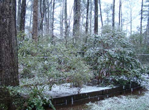
For the last hour or so it’s been snowing in Lawrenceville. Big, heavy white flakes continue to fall, causing some of the shrubs to bend over as if it was ice. With the temperature having dropped to 33 degrees, the snow is beginning to stick on the grass and cold cars, however it’s turning to slush on roads, walks and driveways.

A picture from a little while ago shows the snow in my backyard:

Snow in Lawrenceville, March 1 2009

Looking at the radar, it looks like the heaviest precipitation is falling in the metro Atlanta area. The back end of the snow appears to be along the Georgia/Alabama line, so I don’t know how long it will last. Update: The weather service has issued a winter storm warning for much of north central Georgia, including the metro Atlanta area through midnight tonight. They say we could get an additional two inches of snow. If this is true and tonight’s low temperatures drop into the 20s as expected, it could be nasty in the morning.

The real threat, of course, is not here in Georgia, but further north, from DC to New England, as this storm, combined with the one that pulled through yesterday could be one of the worst of the season as it passes through tonight and Monday.

I’ll post more updates later, but feel free to comment on the snow in your area.

Sphere: Related Content

  • Share/Save/Bookmark