Get Forecast For:
Lawrenceville Weather

Atlanta Gets Second Taste of Snow

Saturday, February 13th, 2010

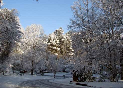
The Atlanta area got its second snowfall of the season on Friday, as a winter storm moved across the south. The snow began falling around 1:30 PM with wet, heavy flakes that immediately began sticking to the grass, and eventually the roads. Overnight, the weather cleared and the temperatures dropped, providing residents with a beautiful winter morning typically seen on Christmas cards.

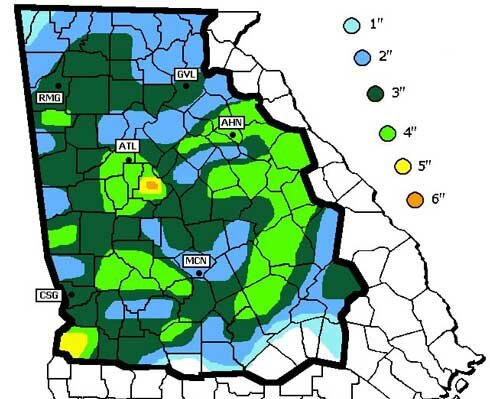
Snowfall totals in Georgia from the February 12th storm include 3.6 inches in Atlanta and 4.5 inches in Athens. The heaviest snow appeared to be in Henry County, with 6 inches. Other reports around Georgia include Savannah with .9 inches and Metter with 2 inches. Charleston, SC reported 3.3 inches of snow.

This morning, there is snow on the ground in 49 of the 50 states, which may be an all time record, according to the AP. People in Hawaii are scouring the tops of mountains there, looking for traces of snow in the only state not reporting snow on the ground. Here is a map of snow cover as of Friday Saturday afternoon:

With temperatures expected to reach over 40 degrees this afternoon, much of Atlanta’s winter wonderland will melt. But, there’s a possibility of yet more snow on Sunday or Monday. Enjoy the snow while you can.

Sphere: Related Content

Share

DC to get Record Snow This Weekend

Saturday, February 6th, 2010

The weather news this weekend is the predicted record-breaking snow in the Baltimore-Washington area. Atlantans are famous for stocking up on bread and toilet paper whenever the white stuff is predicted to fall, but apparently it’s just as bad in DC, except there they are stocking up on bottled water and liquor.

And then there’s this forecast:

A three foot snowstorm is never a lot of fun – especially when last week’s snow is still on the ground. In 1077, I was living in Meadville, Pennsylvania, which is about 90 miles north of Pittsburgh. We got three feet of snow over a two day period, and I had to walk to work in it (or maybe it was wade to work in it). At the time, I was working as a newscaster on the local radio station. ABC radio news called from New York for a snow report. I think that was the only time I ever made an appearance on a national radio news broadcast.

As of 11 PM, it looks like snowfall between 4 and 18 inches has been reported in the Virginia/DC/Maryland/West Virginia area. The show is expected to last through Saturday night.

Sphere: Related Content

Share

Winter Storm Brings Up To 7 Inches of Snow to North Georgia

Monday, March 2nd, 2009

The Atlanta area saw its first snowfall in over a year on Sunday as March roared in like the proverbial lion. Precipitation changed from rain to snow around noon, and the snow continued to fall until around dark. Unfortunately for snow lovers, the already wet ground and warm soil temperatures meant that much of the snow didn’t stick, although it was enough to close most Atlanta area schools this morning.

Georgia snow totals from the storm include:
Atlanta: 4.2 inches
Athens: 6.5 inches
Columbus: 6.5 inches
Macon: 1.0 inches
Gwinnett County: 5.0 inches
Cobb County: 1.5 inches
DeKalb County: 1.5 inches
Henry County: 3.0 inches
Madison County: 7.0 inches

The greatest measured snow total was in Madison county, northeast of Athens.

The storm moved north overnight, bringing similar amounts of snow to major cities on the east coast:
Charlotte, NC: 6.0 inches
Arlington, VA: 8.0 inches
Baltimore, MD: 5.1 inches
Philadelphia, PA: 5.3 inches
Atlantic City, NJ: 6.8 inches
New York, NY: 7.0 inches
Bridgeport, CT: 8 inches

The weekend’s rain raised the water level on Lake Lanier from 1056.9 feet to 1057.7 feet, with a further increase likely as the snow melts. Atlanta is still short of normal rainfall by 2.5 inches — almost identical to where we were on the first of March in 2008.

While temperatures will be about 20 degrees below normal today and 15 degrees below normal tomorrow, in typical March fashion, we’re in for a big change after that. A warming trend will bring high temperatures to around 70 degrees by this weekend. So, get out and enjoy the snow today, while it lasts.

Sphere: Related Content

Share

Snow Falls on North Georgia

Sunday, March 1st, 2009

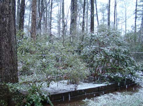
For the last hour or so it’s been snowing in Lawrenceville. Big, heavy white flakes continue to fall, causing some of the shrubs to bend over as if it was ice. With the temperature having dropped to 33 degrees, the snow is beginning to stick on the grass and cold cars, however it’s turning to slush on roads, walks and driveways.

A picture from a little while ago shows the snow in my backyard:

Snow in Lawrenceville, March 1 2009

Looking at the radar, it looks like the heaviest precipitation is falling in the metro Atlanta area. The back end of the snow appears to be along the Georgia/Alabama line, so I don’t know how long it will last. Update: The weather service has issued a winter storm warning for much of north central Georgia, including the metro Atlanta area through midnight tonight. They say we could get an additional two inches of snow. If this is true and tonight’s low temperatures drop into the 20s as expected, it could be nasty in the morning.

The real threat, of course, is not here in Georgia, but further north, from DC to New England, as this storm, combined with the one that pulled through yesterday could be one of the worst of the season as it passes through tonight and Monday.

I’ll post more updates later, but feel free to comment on the snow in your area.

Sphere: Related Content

Share

Storms and Rumors of Storms

Friday, January 30th, 2009

While the last two weeks have been relatively quiet weather-wise in Atlanta, that certainly hasn’t been the case elsewhere in the country. a massive storm earlier this week brought snow, then ice, then more snow to a wide area from Arkansas to Pennsylvania, with Kentucky perhaps suffering the most. State officials there are calling the power outage caused by the ice storm the worst in the state’s history. Chicago has had six or more inches of snow on the ground for the last 20 days, a top ten record, and as of yesterday is recording its third coldest January on record, with a mean temperature of 15.8 degrees, more than six degrees below normal.

Despite a general impression of a cold January in Atlanta, it’s actually been warmer than normal. At Hartsfield, the mean temperature through today is 44 degrees, 1.3 above normal. It’s been a bit cooler here in Lawrenceville, with a mean of 42.5 degrees, but that’s to be expected. The January mean temperature in 2008 was actually over a degree cooler than this year, although 2007 and 2006 were both above normal.

After this weekend, which could be quite pleasant, we have the threat of the worst storm of the winter season. The eyes of the weather world are focusing on Monday and Tuesday, when a powerful storm will start in the southeast and move north, bringing a chance of snow to North Georgia, and likely a doozy of a storm to the mid-Atlantic states.

Most of the country’s weather this winter has been affected by the northern branch of the jet stream. In essence, the northern branch divides cold Canadian air from the (slighly warmer) air to the south. It can dive south, as we saw mid-month when we got the coldest temperatures of the season. For the first time this winter, the southern branch is also active as well. The southern branch divides warmer, tropical air to the south and the colder air to the north. When these two branches join back up, you have a good possibility of wintry weather.

The forecast models have been changing from run to run on the position of the two jet streams, and where the snow will fall, but there is a definite possibility that Atlanta could see some wintry weather on Monday or Monday night. In the worst-case scenario, we could see something like what happened in March, 1993, when the Atlanta area got over a foot of snow. Or, we could get just rain, and not much rainfall at that. Keep your eyes on the forecast over the weekend to get updates.

The History of the Global Warming Argument

The founder of the Weather Channel, John Coleman, has published a blog entry describing the history of the global warming (or climate change, to use the current PC term) debate. Coleman says there is no basis for the climate change threat, which he argues was blown way out of proportion because a researcher was looking for more government funding.

Sphere: Related Content
Share