

First Winter Storm Clobbers Midwest, Northeast US
The first major winter storm of the season struck the northern third of the nation over the weekend, bringing an ugly combination of snow, freezing rain, and rain to everywhere from Washington State to New York as a low pressure system combined with cold arctic air moved across the country. Portions of Michigan reported up to ten inches of snow and 1/8th inch of ice from freezing rain this morning, and depending on where you were in Pennsylvania, you got from one to ten inches of snow.
Now, the storm is bearing down on New England, as you can see from the forecast map below:
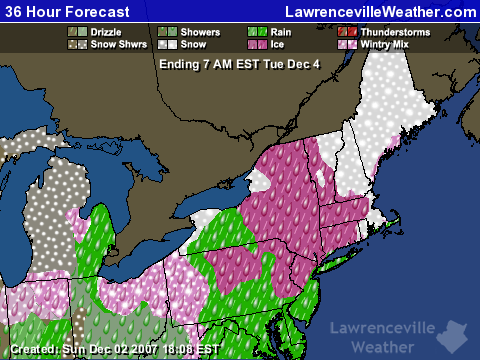
The precipitation is made much more treacherous because the freezing line runs right through the area the storm is hitting in Pennsylvania and southern New England. The northeast is going to get a one two punch. After the current storm moves out Monday night, a second clipper will track across the area on Wednesday.
Here in Georgia, we’ll be lucky to get half an inch of precipitation as the cold front associated with the low crosses the state overnight Sunday. Following that, we’ll have some cooler temperatures this week before a warmup the week of the 10th, when temperatures will again rise to the mid 60s.. Don’t expect much rain during this period, though. After tonight, we may not see rain until the second half of December.
Sphere: Related Content