Fay Brings Welcome Rainfall, With Maybe More to Come
Tuesday, August 26th, 2008It looks like the worst of Fay has finally left north Georgia, although some counties to the east of Atlanta are having tornado warnings, the tornado watch was just extended until 2 AM Wednesday for much of northeast Georgia and South Carolina, and a flash flood watch remains in effect until 8 PM. We may get a few more showers overnight, but there are bits of blue skies showing. Fay is becoming extratropical, and will move northeast to bother the mid Atlantic states for the next day or so.
Let’s take a look at some of what Fay has done. First of all, Lake Lanier has risen about six inches as of noontime today from where it was early Monday morning. Much of the Lake Lanier watershed received some good rainfall over the past day or two, including Gainesville, with 2.64 inches so far today and .73 inches yesterday and Helen with 4.01 inches over the past two days. I expect Lanier to continue to rise over the next few days as much of the runoff from the storm continues to flow into the lake.
With 2.07 inches of rain today and .99 inches on Monday evening and Tuesday, I’ve recorded 48 hour precipitation of 3.06 inches at my weather station. Today’s rain here is the most in one calendar day since November 15, 2006, when 2.19 inches of rain fell, and as best as I can tell is the most 2 day precipitation since Tropical Storm Cindy came through on July 6-7, 2005, leaving 4.62 inches of rainfall.
My station, which is obviously not official, is on the low end of the rainfall scale. Some other two day rainfall totals include Alpharetta with 5.39 inches, Atlanta Hartsfield with 3.09 inches, Cleveland with 5.14 inches, Cumming with 4.52 inches and Cedartown, with 2.87 inches. It looks like Thomasville, Georgia is going to have the most rainfall from Fay–even beating anywhere in Florida–with a whopping 27.5 inches total precipitation through 2 PM today.
Sphere: Related Content

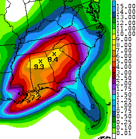
 Now, the big question is how much more rain Fay will bring to the southeast before she finally disappears. To the right is the five day total rainfall forecast from Sunday morning through Friday morning. With the expectation that Fay will move northeast beginning tomorrow and that low pressure systems typically eject most of the rain to the right of the storm’s center, there still remains a reasonable chance for north Georgia and Alabama to receive some drought relief before it’s all over.