Fay’s Remnants May Still Bring Rain to Atlanta and North Georgia
As she continued to move over land, Fay was downgraded to a tropical depression last night, and the Hurricane Center issued its last advisory for the storm. Her center was located 70 miles southeast of Jackson, Mississippi late this morning, and her remnants will drift towards the Mississippi Valley before starting to turn northeast later this week. By Thursday evening, the center of the remnant low is expected to be near the Alabama/Tennessee/Mississippi border.
Since crossing into the Florida peninsula late Monday, Fay has dumped a lot of rain in Florida and along the Gulf coast. Here are some rainfall totals from the storm as of 8 this morning:
Melbourne Beach, Florida - 25.28 inches
Cape Canaveral, Florida - 22.83 inches
Tallahassee, Florida - 19.17 inches
Jacksonville, Florida - 11.58 inches
Valdosta, Georgia - 8.54 inches
Albany, Georgia - 4.92 inches
Savannah, Georgia - 3.16 inches
Columbus, Georgia - 3.15 inches
Brunswick, Georgia - 2.89 inches
Dothan, Alabama - 4.17 inches
Montgomery, Alabama - 3.81 inches
Jackson, Mississippi - 3.92 inches
Beaufort, South Carolina - 5.34 inches
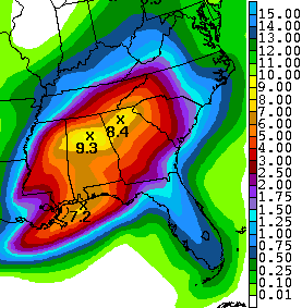
 Now, the big question is how much more rain Fay will bring to the southeast before she finally disappears. To the right is the five day total rainfall forecast from Sunday morning through Friday morning. With the expectation that Fay will move northeast beginning tomorrow and that low pressure systems typically eject most of the rain to the right of the storm’s center, there still remains a reasonable chance for north Georgia and Alabama to receive some drought relief before it’s all over.
Eight to nine inches of rainfall in Lake Lanier’s drainage basin would be such a bad thing, It’s all going to depend on when, where and if Fay stalls out.
Sphere: Related Content
