Archive for the ‘Winter’ Category

Cold Air Damming Makes Freezing Rain Likely Thursday

Tuesday, January 15th, 2008

It looks like things could get fairly nasty Wednesday Night and into Thursday for much of the Atlanta area north of Interstate 20, and especially for the northeast counties, including Gwinnett.  An incoming low pressure system in the Gulf of Mexico will bring precipitation to Georgia beginning Wednesday morning.  Meanwhile, the high currently over the eastern part of Kentucky will move northeast, running into the Appalachians, and causing a ‘wedge’, or cold air damming to affect northeast Georgia.

What happens is that the colder air gets trapped on the western edge of the mountains, and the approaching lower pressure, warmer air slides above the colder, heavier air. You can tell when we’re in a CAD situation when the wind comes from the east, and it doesn’t warm up much during the day.

The presence of warm air above cooler closer to the ground tends to favor the formation of sleet or freezing rain, since the warm air layer will melt any snow as it passes through, while the cold air close to the ground will either re-freeze the precipitation, or cause freezing when the water hits the surface.

In the last day, forecasters have increased the total amount of expected precipitation from the storm to almost an inch, while dropping the low temperature Wednesday night, especially in the northeast counties most affected by the wedge.

(more…)

Sphere: Related Content

Changing Weather Pattern Could Bring Snow to Atlanta Midweek

Sunday, January 13th, 2008

For fans of changing weather, January so far has been right on target. After starting the year with temperatures well below normal, last week brought high temperatures 15 to 20 degrees above normal.   This week, the pattern will change again, and  bring the possibility of some  sort of frozen precipitation to  North Georgia.

A cold front will move through Georgia today, although it won’t bring any sort of precipitation. After the front passes, look for skies to clear, and temperatures to return to normal or slightly cooler than normal.

Things begin to get interesting on Wednesday, as a low pressure system develops in the Gulf of Mexico, and moves northeast into Georgia, bringing gulf moisture and a chance of precipitation by Wednesday night.  Meanwhile, high pressure out of Canada will force the jet stream southward, bring colder air to the region.  Exactly where these two systems meet will determine what type of precipitation we get.

Right now, forecasters are calling for half an inch of precipitation from the system, with lows Wednesday night just below freezing.  If the storm sticks around long enough, lows will be in the upper 20s Thursday night after daytime temperatures only in the 40s.  It’s possible we could get snow, freezing rain, or sleet, and south of Interstate 20, it will probably be all rain.

The forecast is still long range with plenty of possible outcomes, so I wouldn’t go and get the  sleds out yet.  But, it’s worth keeping an eye on.

Sphere: Related Content

Morning Low Temperatures Coldest in Three Years

Thursday, January 3rd, 2008

This morning’s low temperature of 16.5 degrees in Lawrenceville, Georgia was the coldest I’ve recorded since January 24th, 2005, when the thermometer dropped to 14.6. It’s not a record for the day - that honor is held by 1928, where the temperature dropped to nine degrees in Atlanta.

The coldest weather of the 2007-2008 winter season spread throughout Georgia and Florida, with temperatures (as of 7 AM) including:

Albany, GA - 22
Athens, GA - 17
Atlanta, GA - 15
Brunswick, GA - 27
Destin, FL - 26
Gainesville, FL - 22
Macon, GA - 20
Naples, FL - 34
Orlando, FL - 31
Pensacola, FL - 23
Savannah, GA - 25
Tampa, FL - 29
Valdosta, GA - 24

Yesterday, the temperature topped out at 31.2 degrees here in Lawrenceville, and 30 in Atlanta, which is about 22 degrees below normal. As best I can tell, the last time the high temperature didn’t break the freezing mark was on January 29th, 2005, when we had a high temperature of 31.3. Wind chill readings yesterday didn’t help either, with readings in the single digits.

This week’s weather may turn out to be the coldest of the year. Temperatures will begin to moderate today, and we could see highs around 40 today, near 50 on Friday and in the 60s for the weekend, and into next week. Look for another cold night tonight though, with lows around 20.

Sphere: Related Content

Early Season Snow/Ice Dumps on Plains; Heads East

Thursday, December 13th, 2007

A brutal storm that left a million people without power in the Plains states has moved east, and is causing trouble from Ohio to Massachusetts, and another storm is on the way to potentially make things worse this weekend.

Oklahoma, Missouri, Kansas and Iowa (among others) were affected by power outages and dangerous driving conditions this week.  The satellite image below, taken earlier this afternoon, shows the effects of the storm:

Snow over the Plains States

The storm has now moved east, and is causing problems from Ohio through New England, with winter storm warnings posted, and up to a foot of snow forecast for portions of Pennsylvania and New York.  Because of the warm weather we are seeing in the Southeast, some areas along the boundary between the cold and warm weather are seeing combinations of snow and freezing rain.

In the Atlanta area, the passing storm brought only a slight amount of rain - certainly not enough to help the drought.

Another storm, currently over Texas, will travel Northeast, and bring additional precipitation and snowfall  to the Northeast, with another foot of snow for portions of New York, Massachusetts, and Vermont.  While forecasters had originally thought that the system would be far enough south to bring some meaningful rainfall to North Georgia, it now appears that the storm will track north, and might leave less than half an inch of rain.

The storm will bring some more seasonable weather to the Atlanta area though, with Sunday likely to be the coldest day.  It will stay cool for the first part of next week, and then warm up going into the Christmas holiday.  Meanwhile, there’s another chance for some wet weather in the middle of next week, and again next weekend.

Sphere: Related Content

First Winter Storm Clobbers Midwest, Northeast US

Sunday, December 2nd, 2007

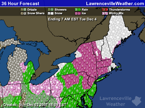
The first major winter storm of the season struck the northern third of the nation over the weekend, bringing an  ugly combination of snow, freezing rain, and rain to everywhere from Washington State to New York as a low pressure system combined with cold arctic air moved across the country.  Portions of Michigan reported up to ten inches of snow and 1/8th inch of ice from freezing rain this morning, and depending on where you were in Pennsylvania, you got from one to ten inches of snow.

Now, the storm is bearing down on New England, as you can see from the forecast map below:

360 hour weather forecast for New England

The precipitation is made  much more treacherous because the freezing line runs right through the area the storm is hitting in Pennsylvania and southern New England.  The northeast is going to get a one two punch.  After the current storm moves out Monday night, a second clipper will track across the area on Wednesday.

Here in Georgia, we’ll be lucky to get half an inch of precipitation as the cold front associated with the low crosses the state overnight Sunday.  Following that, we’ll have some cooler temperatures this week before a warmup the week of the 10th, when temperatures will again rise to the mid 60s.. Don’t expect much rain during this period, though.  After tonight, we may not see rain until the second half of December.

Sphere: Related Content