Archive for the ‘Long Term Outlooks’ Category

Upcoming La Nina Could Mean a Strong Hurricane Season

Monday, March 5th, 2007

The Weather Service is hinting that we may be moving into La Nina conditions as spring moves into summer. In a press release, the agency says the warm sea surface temperatures that characterize El Nino conditions are rapidly decreasing, and that cooler waters in the eastern Pacific are a sign of an upcoming La Nina episode.

If indeed we move into a La Nina cycle, the effect is likely to be a more active than normal Atlantic hurricane season this summer. Should the cool ocean temperatures persist, it could mean a warm and dry winter season next year in the Southeast. Other than the chance of increased hurricane activity, La Nina cycles don’t provide much influence on temperatures or precipitation in the summer in the Southeast.

Meanwhile, if it seems like it’s gotten a bit cooler than it has been, you are right. Last week’s temperatures were above normal, which makes the effect more apparent, but the overall weather pattern right now is similar to what we saw in early February. Of course, the increased daylight limits the cold air’s push into the south — in fact, aside from some cool nights, most of the weather effects will be north of the mid-Atlantic states. It should be warming up again soon, with expected above normal temperatures for most of next week.

Sphere: Related Content

Second Half of February Looks Better Than the First

Thursday, February 15th, 2007

The recent weather pattern that has led to an unusually cold first half of February is likely to end once we get past this weekend. This morning’s low temperature of 23 degrees here in Lawrenceville was a full 13 degrees below normal, and it looks like we’ll be seeing similar lows through the weekend, as cold Canadian air pushes south in the wake of the blizzard that left some parts of the Northeast US with more than a foot of snow.

There is also a chance of some wintry precipitation on Saturday. The GFS model has been advertising snow for Saturday night in North Georgia since last weekend, although while it will be cold enough, there may not be enough moisture to cause any serious precipitation.

After President’s day, though, the weather picture begins to brighten as the jet stream changes to a flatter pattern. For much of January, a trough, or upper air low pressure, sat over the western US, while a ridge (or high pressure upper air) dominated the eastern half of the country. That allowed the colder air into the west, and kept it from penetrating the east. You can see the result in the map below.

That pattern reversed itself in late January, with a ridge in the west and a trough in the east, and much below-normal temperatures in Georgia. We are still about 3 degrees cooler than normal for the month so far.

The medium range outlook from the 21st through the end of the month calls for warmer than normal temperatures, as the northern jet stream retreats. We’ll be likely to see daytime highs in the sixties, and low temperatures staying above the freezing mark.

Is this winter’s last blast? The Weather Service’s long range outlook for March, which was released today, calls for equal chances of above, below or normal temperatures and precipitation for the eastern half of the country, and it reports that the effects of the El Nino are dying out. All we can do is hope for the best.

Sphere: Related Content

Groundhogs Agree: Spring is Just Around the Corner

Friday, February 2nd, 2007

After a day that brought up to six inches of snow in Dahlonega, and icy conditions to parts of the north metro area (but not Gwinnett County), the groundhogs have made their annual predictions for the arrival of spring.

Both Beauregard Lee and Punxatawny Phil woke up this morning, and didn’t see their shadows. According to legend, this means that spring is just around the corner.

You wouldn’t know it from some of the more traditional models of weather forecasting. The overall weather pattern in the United States has a ridge in the west, and a trough in the east. This is allowing brutally cold air to descend from Canada into the middle of the country and then move eastward, while the western part of the country stays warm.

This weather pattern will probably stay in place for the next week to ten days. Even though the coldest part of winter is theoretically over, we’ll be lucky to see 50 degrees the week of the 12th, even though by then the high should be around 55. After that, there’s a possibility that the pattern will shift to more favorable weather, or at least something that gives us the possibility of seeing 60 during the day.

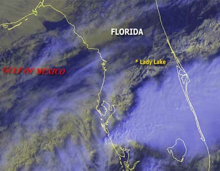
Meanwhile, central Florida got a taste of one of the bad things about spring — strong tornadoes. At last report, at least 19 people died when a tornado ripped through the Orlando area early this morning. The satellite picture below shows central Florida this morning, and highlights Lady Lake, one of the towns severely damaged by the cyclone.

Here in Georgia, we typically don’t get the worst tornadoes until March. The Weather Service has scheduled Severe Weather Awareness Week for the week of February 19th, including a statewide tornado drill on the 21st.

Sphere: Related Content

More Wet Weather Ahead Before Cold Kicks In

Saturday, January 20th, 2007

The next two weeks are likely to be good examples of one of my general rules about winter weather in north Georgia: when wet weather arrives, it’s too warm to snow, and when it’s cold enough to bring the white stuff, we’re in a dry period.

The southwesterly flow of the jetstream is going to bring wet weather for most of the upcoming week, beginning with rain late tonight and Sunday. Unlike Thursday’s front, which brought only light precipitation, this system is stronger, and could bring an inch of rain. This time, though, the cold air is further north, so there’s no worry about freezing rain or sleet, in metro Atlanta, although the northwest corner of the state could see a little sleet.

The chance of rain continues throughout the week, as the system basically stalls over our area until Thursday, when things clear out for the weekend. At that point, we may see the long awaited pattern change to colder air. High Temperatures for the last week in January are likely to be in the 40s, with lows in the 20s. It’s also likely to be a relatively dry period, without much of a chance for snow or ice.

The Weather Service is continuing on its El Nino theme in its long range outlook for the month of February. They predict above normal temperatures for the northern Mississippi Valley, stretching through Tennessee, and then normal temperatures for the southeast. They also predict above normal rainfall for Florida and south Georgia, but equal chances of above or below normal precip for Alabama, north Georgia, and North Carolina. Accuweather.com disagrees, predicting colder than normal weather for the eastern half of the country, with above normal precipitation.

In the unusual weather department, much of Europe is recovering from hurricane-like weather from a storm named Kyrill that brought 125 MPH winds, power outages, downed trees and transportation delays from Britain to Czechoslovakia on Thursday. The storm, which is reported to be the worst in 25 years, caused over $1 billion in damage.

Sphere: Related Content

One More Week of Warm Weather - But the Real Cold May Be in February

Thursday, December 14th, 2006

I hope you’ve had a chance go go out and enjoy the warmer than normal temperatures we’ve had this week. We’ve seen temperatures about ten degrees above normal, and it looks like temperatures could get into the low 70s over the weekend.

Of course, it can’t go on forever. The pattern is likely to change a week from now, after a good chance of rainy weather midweek next week. After that, look for temperatures approaching normal to slightly below normal through the end of the year.

If you want to get a peek at what we could see for the rest of the winter, check out this graphic. It shows the expected deviations from normal for temperatures for the next six months, based on the CFS climate modeling system developed by the National Weather Service.

The models show a colder than normal December in Georgia–we are running about 3 degrees cooler than normal this month– followed by a normal to slightly cooler than normal January, a better chance for a cold February, a normal March, and a cold April. While these aren’t official forecasts, they do give some indications of what models say we’ll see this winter.

Even though the winter solstice is one week away, today was the first day since last July that the sun set later in the day than it did yesterday. Although we’ll see later sunrises for another three weeks, we’ll gain about ten minutes of evening light between now and the first of the year.

Sphere: Related Content