Archive for the ‘Tropics 2007’ Category

Two Storms Threaten to Become Hurricanes

Wednesday, August 15th, 2007

After two months of doubting Thomases saying “What hurricane season?”, we not have two tropical storms, at least one threatening to become a hurricane, and both threatening the Gulf of Mexico.

he most immediate threat is Tropical Storm Erin, shown below. Seemingly cropping up out of nowhere last last night, the storm is gaining strength, and before it hits landfall, it should have wind speeds of 63 MPH, about 10 MPH short of hurricane strength. Tropical storm warnings have been posted for South Texas from San Luis Pass southward. While the exact landing point sometime Thursday isn’t certain, storm force winds extend 70 miles out from the center of the storm, and much of the Texas Hill Country could get more than 6 inches of rain — if they haven’t had enough already.

The next actor in this play of tropical weather is Tropical Storm Dean, which will likely become a hurricane by Thursday morning. Dean’s track is shown below:

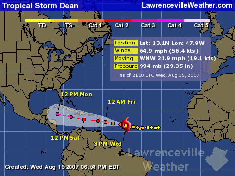
Dean has been moseying along for a few days now, but is rapidly gaining strength as he approaches the Caribbean. Expected to pass just south of Jamaica on Sunday, the real question is what happens once he reaches the Gulf of Mexico sometime Monday evening. The high pressure system that’s giving Atlanta 100 degree temperatures for the second week in a row is powerful enough at the present time to prevent the storm from recurving to the north.

If the ridge stays strong, the storm will slam into the Yucatan peninsula of Mexico, and some of the models show this to be happening. if it weakens, then the US Gulf is vulnerable to what could be a very powerful hurricane. Since whatever happens is more than five days out, even the best forecasters (and I’m not one of them) aren’t sure what will happen.

Sphere: Related Content

Tropical Depression Four Forms in Atlantic

Monday, August 13th, 2007

The National Hurricane Center has officially recognized Tropical Depression Four, which lies in the mid-Atlantic with winds of 35 MPH. It is expected to become Tropical Storm Dean sometime on Tuesday morning. and is projected to become a hurricane by the weekend, when it may be close to the Virgin Islands, headed towards Cuba.

You can view the storm’s projected path here, and view a satellite image here.

At this point, it’s too early to tell where the storm will ultimately make landfall, short of saying it will probably be somewhere in the Gulf of Mexico.

Atlanta’s hot weather got a break on Sunday, when a summertime version of the wedge brought east winds, and cloud cover that lasted through mid afternoon, and kept high temperatures in the 80s. After four days of record-setting heat (another temperature record was broken on Saturday), I’m sure everyone enjoyed the break. We could see more records broken this week, with high temperatures in the upper 90s through Friday. By that time, we’ll be in a better position to see what effect Dean will have on Georgia.

Sphere: Related Content

You know It’s Hurricane Season When…

Thursday, July 26th, 2007

We’re almost two months into the official hurricane season, which runs from June 1st to November 30th, and so far, we’ve had only two named storms. Given the various predictions for between 13 and 17 named storms, it may seem to some that we’re not going to make it.

Keep in mind that the strongest part of the hurricane season is from mid-August to mid-October, when the Atlantic Ocean is at its warmest. With the exception of 2005 and 2003, when we had seven storms by the end of July, for the past ten years, we’ve seen two tropical storms each year before August 1st, except for 1998 and 2004, when there weren’t any storms at all in the first two months of the season, so we’re on schedule.

The approach of the strongest part of the hurricane season brings a reminder from the Georgia State Climatologist David Stooksbury that Georgia could be severely impacted should a Katrina-like storm hit the coast. In an article posted yesterday on the Georgia FACES website, Stooksbury reports that UGA students created a model of the storm surge from Hurricane Katrina, and then projected it along the Georgia coast, where it would cause a 20-30 foot storm surge.

“A storm surge of this magnitude would wash over the barrier islands and lead to massive flooding along the coast. Almost all of Georgia east of I-95 will be under water with a category 3 hurricane. Areas west of I-95 will see major flooding, too.”

The article also explodes some Georgia hurricane myths, and offers advice on preparedness.

Next week brings updates to the hurricane forecasts by the National Weather Service and Dr. Gray’s team over at Colorado State University, and it will be interesting to see what changes, if any, we see in the predictions.

Dr. Gray has written an op-ed article for this morning’s Wall Street Journal examining if the increases we’ve seen in the intensity of hurricanes recently is being caused by global warming. He compares two long term periods from the early 20th century and late 20th/early 21st, and concludes that the number of landfalling hurricanes in the US declined, despite the increase in carbon dioxide in the air.

Instead of following the politically correct line on global warming, Dr. Gray analyzes the patterns of ocean currents and salinity in the Atlantic over time, and concludes,

“The warming theorists — most of whom, no doubt, earnestly believe that human activity has triggered nature’s wrath — have the ears of the news media. But there is another plausible explanation, supported by decades of physical observation. The spate of recent destructive hurricanes may have little or nothing to do with greenhouse gases and climate change, and everything to do with the Atlantic Ocean’s currents.”

If you’re not a Wall Street Journal Online subscriber, you can read the article via Google News. Click this link, and choose the article “Hurricanes and Hot Air”.

Sphere: Related Content

Barry Brings Little Relief to Rain-Starved Metro Atlanta

Sunday, June 3rd, 2007

Tropical Storm Barry came through Georgia on Saturday, however the storm’s path was too far east to bring any benefit to most of the metro Atlanta area. The storm barely made it into Gwinnett County, bringing less than a tenth of an inch of rain. Further south, however, the area between Macon and Statesboro received two months worth of rain in a single day.

This map shows estimated precipitation amounts from the storm, as of 8 AM on Sunday:

Reported rainfall ranged from a trace in Atlanta to 6.48 inches in Kite, which is north of I-16 between Wrightsville and Swainsboro. Other Georgia amounts recorded include:

Alma - 3.60 inches
Athens - 0.49 inches
Augusta - 2.59 inches
Brunswick - 3.06 inches
Covington - 0.25 inches
Dublin - 5.70 inches
Gainesville - 0.09 inches
Macon - 2.31 inches
Savannah - 5.15 inches
Washington - 1.28 inches

So, what’s the good and the bad from the storm? The south Georgia wildfires were diminished, but not put out completely. Middle Georgia farmers may be able to put out long-delayed crops. The Georgia climatologist may delay putting the entire state into a level 3 drought, which would limit outdoor water use to one weekend day per week.

This morning’s Gwinnett Daily Post reports that Gwinnett will likely be put into the extreme drought category, meaning a drought so severe that it normally occurs once every 50 years. While that designation would make official what has become increasingly obvious, it probably won’t affect water restrictions in the county, unless a statewide restriction is issued.

(We’ll give a hat tip here to Wayne Hill, who had the foresight to build a strong water infrastructure during his term as county commission chairman).

Now that Barry has passed through, though, we are going to see some changes towards a more normal summer weather pattern. The tropical system managed to move the high pressure that has been keeping all rain away for most of May out of the way, and that will allow air from the Gulf Coast into the area, bringing Georgia’s normal summertime companions, heat and humidity, into the state, along with a chance of thundershowers. This week, we’ll probably break 90 degrees for the first time in 2007, and the outlook for the next two weeks is for warmer and drier than normal weather. It’s likely to stay hot for the entire month, as well.

Sphere: Related Content

Hurricane Season Starts On Time with Tropical Storm Barry

Friday, June 1st, 2007

Tropical Storm Barry became official at 5 PM on Friday June 1st, the first day of hurricane season. The system was centered 320 miles southwest of Tampa, with 45 MPH winds, and a tropical storm warning was issued for most of the west coast of Florida.

You can follow the storm’s progress here.

Now the question is how much rain the storm will bring. It’s not likely to develop into a hurricane, but looks likely to have an impact on the south Georgia wildfires, and depending on whether it goes east or west, could help with the drought in the rest of Georgia as well.

Sphere: Related Content