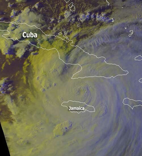
Severe Weather Strikes Early in the New Year

Monday, January 2nd, 2006

It didn’t take long for severe weather to make its presence known in 2006. Between 4 and 7 PM on January 2nd, a line of severe thunderstorms, some with tornadoes, struck the metro Atlanta area, primarily on the south side. The entire metro area was under a tornado watch, while severe thunderstorm and tornado warnings were issued in Gwinnett, Fulton, Fayette, and other metro area counties.

Early reports indicated a tornado strike in the Fayetteville/Peachtree City area. Despite Gwinnett’s tornado warning, no major damage has been reported at this time, although Channel Five tracked tornado signs on radar through Snellville, Grayson, and Loganville.

Part of the reason that the storm didn’t affect Gwinnett as heavily as it might have was the relatively cooler temperatures in the northeast part of the state. While in Alabama, highs reached 80 degrees, here, the high was kept in the low 60s due to east winds caused by mild wedging.

Looking forward, once the cold front that is approaching Atlanta and causing these storms passes through, we’ll see drier air, and more pleasant weather through the end of the week. Forecasters expect an upper-level trough to be centered well to our east, over the Atlantic, which should keep precipitation away. However, the exact positioning is still uncertain, and with colder upper air at the end of the week, if we do get some precipitation, it could be snow flurries — quite a change from the weather early in the week.

Sphere: Related Content

Hurricane Dennis Makes Landfall

Sunday, July 10th, 2005

Hurricane Dennis made landfall about 20 miles east of Pensacola, Florida about 3:30 PM EST on Sunday. Estimated wind speeds were about 115 MPH. By 6 PM, the storm had crossed into Alabama, with winds still holding at 105 MPH. Overnight the storm is expected to move into Mississippi, and reach the Tennessee border sometime around noon on Monday.

The picture below shows Dennis about 35 minutes prior to landfall.

The storm is expected to dissipate slowly, landing near Vincennes, in southwestern Indiana by 1 PM Wednesday, and staying fairly stationary through Friday afternoon and bringing about 8 inches to that rain-starved area.

In Gwinnett, Dennis has brought less than 1/4 inch of rain so far, with most falling on Saturday evening. The Metro Atlanta area hasn’t been so lucky, with possible tornadoes in Atlanta, Butts County, and, in general, south of I-20. Gwinnett remains on a flood watch through 6 AM Monday. We can also expect to see up to three and a half inches of rain through Tuesday.

Sphere: Related Content

Catching Our Breath Between Cindy and Dennis

Friday, July 8th, 2005

Atlanta should be in for a bit of better weather for the next day or two, as Cindy moves further to the North, and Dennis remains too far south to affect the area. The Weather Service has confirmed six tornadoes as a result of Cindy’s passing through the area. The strongest tornado, rated F2 on the Fujita scale, ran through Henry County for almost nine miles, and caused over $40 million worth of damage to Atlanta Motor Speedway. Additional tornadoes were observed in McDonough and Fayetteville, as well as further south in Meriwether and Coweta counties.

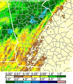
The 5.14 inches of rain that fell at Atlanta’s Hartsfield Airport was the sixth largest one day total rain amount ever recorded for that location. The worst of the rain was in a band that stretched from south Fulton county, to south DeKalb, to south Gwinnett. Additional rainfall totals for Cindy include:
Athens: 4.12 inches
Gainesville: 1.92 inches
Marietta: 2.45 inches
Rome: 1.55 inches

The map on the right shows National Weather Service estimated 24 hour rainfall totals through 8 AM Thursday.

Meanwhile, Dennis has turned into a dangerous Category 4 hurricane. Currently located south of Cuba, the storm is moving northwest at 16 MPH. Maximum sustained winds are about 135 MPH.

The current official forecast calls for Dennis to strike the Gulf Coast near the Alabama-Florida border sometime late Sunday or early Monday, and then move inland towards the northwest. However, satellite models continue to disagree about the exact landing point and path of the storm, with some models calling for a more westerly path, while others have the storm more to the east. As far as our weather goes vis a vis Dennis, if it’s to the east, we will likely see a repeat of the rain that Cindy brought, while if it’s to the west, we will miss the worst of the effects.

The picture above, courtesy of NOAA, shows a picture of Dennis as of about 7:30 PM Thursday, with the eye located just north of Jamaica.

Sphere: Related Content

Cindy Rains over North Georgia

Thursday, July 7th, 2005

Tropical storm Cindy dropped over 4 inches of rain over the Atlanta area overnight Thursday, and caused tornadoes, hail, and flooding. Many of the initial problems occurred on the south side of the city as a major storm arrived during the 7 PM hour. Peachtree City reported flooding and nickel size hail. The storm moved northeast, with Jonesboro, McDonough, and Stockbridge reporting storm damage and trees down. Flash flood warnings were declared for Fulton and DeKalb counties, while flood warnings were issued for much of the eastern part of the state of Georgia, including Gwinnett County.

Rainfall amounts varied based on location. Hartsfield Airport reported 5.14 inches of rain, with a maximum wind speed of 43 MPH. Peachtree DeKalb reported 2.86 inches of rain, and Athens reported 4.17 inches.

My weather station recorded 4.35 inches of precipitation for the storm (through 6:00 AM), with about half the rain late Wednesday evening, and the other half early Thursday morning. This is slightly less than the 4.57 inches of rain from last September’s Hurricane Ivan.

As Cindy moves out of the area, we can expect some additional light rain as the day moves on, and then we get a short break before the effects of Hurricane Dennis reach our area. Dennis was located about 225 miles south of Guantanamo, Cuba. Hurricane force winds were reported at 90 MPH.

Sphere: Related Content

Fast Moving Storm Brings Tornado Watch

Saturday, April 30th, 2005

Forecasters have been calling for the possibility of severe weather all week, and it looks like the frontal boundary is fast approaching the metro Atlanta area.

The National Weather Service has issued a tornado watch for much of central Alabama and West Georgia, but not yet including Gwinnett County from 6 AM through 1 PM. You can see the watch area in the map below, which reflected the state of the storm around 8:30 AM:

Even though we’re not in the watch area now (and I’m not saying that the watch area won’t be extended - it has been several times overnight as the front has moved eastward), there is a chance of strong thunderstorms, heavy rain and damaging hail as the front moves east.

The squall line began to pass through Gwinnett around 7:30 AM, and by 8:30 AM, the leading edge of the storm had passed through the county. Most of the bad weather appears to be to our south, and indeed at 8:10 AM, the National Weather Service issued a severe thunderstorm watch from the Florida panhandle through Augusta, well to the east and south of metro Atlanta.

By this afternoon, things will slow down, and by this evening, the skies will begin to clear, for the start of May.

Sphere: Related Content