Archive for the ‘Tropics 2005’ Category

We’re Not Done With Tropical Weather Yet

Sunday, October 9th, 2005

Looking back at the first week of October, it appears that the hurricane season hasn’t ended yet. In addition, recent storms have become curiouser than ever.

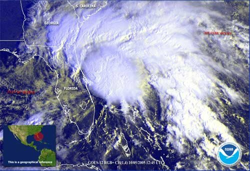
The week’s highlight, particularly here in Georgia, was Tropical Storm Tammy, which developed off of the Florida coast, and then moved across south Georgia, eventually curving to the southwest over Alabama, and back into the Gulf of Mexico. Nonetheless, it managed to bring 1.79 inches of rain to Hartsfield Airport, and almost 3 inches of rain to Lawrenceville.

The next reported storm was Subtropical Depression 22. The official reason it was a subtropical depression rather than the normal tropical depression is that much of its energy was derived from a low pressure system to its south. Originally predicted to move northwest into the New England states, within 24 hours it was history, with the Hurricane Center having decided the storm had dissipated to the point where it was no longer a cyclone.

This morning’s surprise was the appearance of Tropical Storm Vince, now Hurricane Vince. Unlike most storms tracked by the National Hurricane Center, Vince is moving towards the northeast, and is expected to weaken, and strike the Iberian coast near the northern border of Spain and Portugal sometime Tuesday morning. The forecast track as of 5 PM Sunday is below:

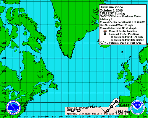
In justifying listing Vince in what is nominally an American storm warning system, the Hurricane Center claims, “If it looks like a hurricane, it probably is.” The storm has winds of 75 MPH, and a pressure of 29.15 inches, which is certainly within hurricane range. It just seems odd to track a storm that is located near the Madeira Islands.

Now that the name Vince has been claimed by a storm, what’s left. Well … it’s Wilma. Once Wilma makes her appearance — and it’s looking like a strong possibility that we may see her later this week — we’ve run out of the 20 names designated for Atlantic storms for 2005. Should there be any more (remember the tropical season doesn’t stop until the end of November), they will be named using Greek letters, starting with Alpha, and continuing with Beta, Gamma, Delta, Epsilon, and so on.

What’s the weather likely to be in Lawrenceville over the next few days? We’re on the western edge of a low pressure system extending from Florida north to Maine along the Atlantic Coast. That system is likely to bring more damp weather through Wednesday morning, although not a lot of rain. After that, our weather may be determined by what’s going on in the Atlantic. Temperatures will continue to get cooler as well, with a possibility of an overnight low below 50 degrees as soon as next weekend.

Sphere: Related Content

Tammy Pounds Georgia Coast; Takes Aim at Atlanta

Thursday, October 6th, 2005

Tropical storm Tammy came ashore about 7 PM Wednesday near Mayport, Florida, just south of the Georgia state line. With winds around 40 MPH, she remains a tropical storm whose center is located near Tifton, Georgia.

At the risk of sounding like Jim Cantore of the Weather Channel, I was able to see the storm close-up having traveled to Jekyll Island on Wednesday. After seeing a number of rain bands (and quite a bit of wind) on the way down here, the worst of the rain started around 6 PM, as lightning struck, and the winds picked up.

Driving along Beachview Drive around 7 PM, there was considerable ponding of water, and it was nearly raining sideways. By about 8:30 PM, the rain had stopped, at least temporarily, as the center of the storm began to move away. You could still see a lot of water on the roads, an in yards and the golf courses. The bellman at the hotel reported that along I-95, many cars and trucks had gone off the road due to the high winds and water. The weather service reported 4.7 inches of rain at St. Simons on Wednesday. The rain continues this morning, although with the worst of the storm to the north and east of the center, I hope that I’ll be able to get out on the golf course sometime today.

The picture above is of Tammy around 10 AM on Wednesday morning.

What’s in store for the Atlanta area? Fortunately, a break in the dry weather that we’ve seen for the last month. The outer edges of Tammy arrived late last evening, and the storm could bring up to two inches of rain by the time the storm exits on Friday night.

The weather for next week remains unsettled. The country in the midst of switching between the summer and winter weather patterns, as evidenced by the cooler weather next week, and much cooler weather this week in the Midwest - St. Louis will be 25 degrees cooler today than yesterday. There is still a chance of more tropical weather like Tammy sometime late next week.

Sphere: Related Content

Tropical Storm Tammy Headed Towards Atlanta

Wednesday, October 5th, 2005

The Weather Service has recognized Tropical Storm Tammy, which is currently near Cape Canaveral, Florida, and is expected to make landfall near Jacksonville this afternoon or this evening. The storm will then head towards the Atlanta area on Thursday as a tropical depression.

Sphere: Related Content

Nor’Easter Could Affect Atlanta Area, In Front of Cooler Weather

Wednesday, October 5th, 2005

North Georgia gets its first real chance of rain in a long time from a tropical disturbance now located over South Florida. Although it’s not officially a tropical storm, the low pressure system is expected to move slowly north over Florida today and tomorrow, then pick up speed, and connect with a low pressure system that is now bringing snow to North Dakota and Minnesota. The result is a nor’easter likely to bring 8 to 9 inches of rain to the Carolina coast, and up to 4 inches of rain to New England.

The amount of rain we’ll see in metro Atlanta is dependent on how far west the center of the storm travels. Right now, it looks like the best chance of rain will be from Thursday morning through Friday night, with likely rainfall of half an inch. This assumes that the storm’s center will move up the coast. However, a few models bring the storm’s center as far west as I-75. If that’s the case, we could see quite a bit more rain.

Once the storm does pass through, we’re likely to see some of the first real cool weather of the season, starting with low temperatures around 50 degrees by Sunday. National Weather Service guidance through the next two weeks keeps the cooler than normal temperatures in the forecast - after today, I don’t see it getting above 80 degrees in the medium term.

Sphere: Related Content

Rita Remnants Offer Best Chance of September Precipitation

Sunday, September 25th, 2005

With six days left in the month, it now looks like the remains of Rita might provide September’s only rainfall. Initial predictions had Rita stuck over the Arklatex area for several days, providing up to 20 inches of rain to the area. Now, the storm has been downgraded to a tropical depression as of this morning. The low that was Rita is predicted to move east across Tennessee on Monday, and may bring rain to North Georgia.

The weather service is predicting half an inch of rain on Monday, which would be the first rain that Gwinnett has seen since Katrina’s remnants came over the area on August 29th and 30th. Even if we get that rain, it will still put this month among the top ten driest Septembers ever. Once Rita passes through, there is only a small chance of some additional precipitation as another front passes through on Thursday.

This September has also been unusual in another way. Our mean temperature so far of 73.7 degrees is almost three degrees above the normal of 71. For the first time in three years, we’ve had 90 degree weather in Atlanta in September. Today’s normal high is 80 degrees, with a low of 61.

Sphere: Related Content