Archive for the ‘Meteorology’ Category

March 9th: Temps 15 Degrees Below Normal

Wednesday, March 9th, 2005

Today’s high of 48 degrees is 15 degrees below the normal high of 63, and this morning’s low of 29 was 13 degrees below the normal low of 42. If you’re like me, you’re probably tired of seeing January temperatures in March.

The eastern half of the country remains trapped in a weather pattern that I discussed in this post, where a warm weather in the western half of the country and a ridge over the north Atlantic contribute to cold Arctic air being pushed into the eastern half of the country.

The good news is that the Pacific North American Pattern, which is responsible for the ridge in the west, is getting ready to transition from being extremely high to dropping below normal, as seen in the following graph from the National Weather Service:


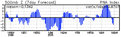
The graph shows that we had a negative PNA in the late part of December and the first part of January, corresponding to the extremely warm temperatures at the beginning of the year. A more modest drop in early February matched the slightly warmer than normal temperatures at that time. The extremely high values since March 1st match our recent January like temperatures.

If the predicted changes hold true, the arctic air intrusion will move further to the west, causing colder weather in the Dakotas, which have been unseasonably mild for this time of year, and allow the weather in the Southeast to be influenced more by the Gulf of Mexico, meaning warmer weather.

Still, I don’t see a forecast of above 70 degrees until at least March 20th, the first official day of Spring. We continue to be threatened by fast-moving weather patterns that could bring a chance of snow. It looks like we dodged the bullet for tonight, but additional short wave activity will return on Friday, and again possibly on Saturday. I’m more worried about a potential storm around St. Patrick’s day that will probably bring additional snow to the Northeast, but could affect us.

Do you realize that New York City is getting ready to experience its fourth year in a row with over 40 inches of snow — a modern record? Part of the reason for the recent concerns about high gasoline prices is due to the extremely cold weather, not only here in the United States, but in Europe as well. So much for global warming.

Sphere: Related Content

Georgia Severe Weather Awareness Week

Sunday, February 20th, 2005

This week is Severe Weather Awareness Week in Georgia. The National Weather Service holds severe weather awareness weeks in each state, usually about the time of year when that state is most vulnerable to tornadoes, hail, and thunderstorms.

The week will be highlighted by a statewide tornado drill on Wednesday morning.

In addition to tornadoes and thunderstorms, officials will be trying to draw attention to the risks of flooding, lightning, and extreme heat and cold; however for most folks, thunderstorms and tornadoes are the biggest threat, primarily because they can occur with little or no warning.

If you’ve lived in the Atlanta area for a while, you’ll probably remember the severe tornadoes that occurred on April 8th and 9th, 1998. Overnight, storms brought down trees and caused extreme destruction in Cobb County, Dunwoody, Norcross, and Duluth. Many people not in the direct path of the storms woke up the next morning to the terrible news.

At the time, I was working near Georgia 400 and Abernathy Road, near the part of Dunwoody that was largely destroyed. The storm made me think, and I realized that it might be a good idea to buy a NOAA weather radio that would automatically alert me if a tornado or thunderstorm warning was issued in the middle of the night.

Unfortunately, it seemed that there were none to be found in North Georgia. I wanted a newer radio that used SAME technology. This technology only sets off the radio’s alarm if a warning is issued in the county or counties you specify. I didn’t need to be woken up in the middle of the night for a warning that wouldn’t affect me.

I finally located one at a Radio Shack in Cambridge, Massachusetts. They only had one, a demo version. Since I was going to Cambridge on a business trip, I figured I would pick it up there and bring it home.

The punch line, if there is one, is that the unit was defective, and I ended up exchanging it for a new one once they were in stock back here in Georgia.

If there is a moral to the story, it’s be prepared. If you don’t have a weather radio, they are fairly cheap, and could potentially save your life. Go out and get one now, before the severe weather season starts.

Sphere: Related Content

Remember that Yellow Thing?

Thursday, February 3rd, 2005

It seems like forever since we’ve had a really nice day. Despite the fact a week ago yesterday, I was able to sit outside at a coffee shop downtown, enjoying a high of 68, things went downhill quickly, and I think just about everyone is willing to forget this first week of February.

The bad weather here this week is in sharp contrast to what has been happening in the rest of the country. What we’ve seen is what weather folks call a ’split flow’ pattern, where the northern jetstream doesn’t go much below the Canadian border, and the southern jetstream comes north and bothers the Southeast.

This has led to temperatures forecasts for today of 62 degrees in Billings, Montana and 64 degrees in Rapid City, South Dakota. These are places where normal highs for early February are about 25 degrees.

The weather pattern is about to change, though, and Atlanta is headed for a warm-up, at least for a few days. Over the weekend, we should see 60 and very nice weather, with a moderate possibility of rain all next week, although still warm, with daytime highs in the upper 50s to low 60s, and nighttime lows in the 40s.

This is happening as a cold air mass prepares to move down from Canada and into these same areas that are enjoying warm temperatures today. By Tuesday in Rapid City, the forecast high is 20, with a low around 8.

We start to feel the effects of this next Friday and Saturday, which will be the first time temps drop back below the freezing mark. Overall, the National Weather Service forecast calls for above normal temps through the middle of next week, normal temperatures from the 9th through the 13th, and below normal temps until the 17th.

If there’s any consolation to all of this, it’s that less than normal precipitation is predicted for the next two weeks.

Wind Speeds

Weather Forecasting 101

Wind direction can tell us a lot about what is going to happen with the weather in the short term. To the right is today’s wind direction plot, which shows a transition from mostly easterly winds before noon, to mostly westerly winds after noon. The change in wind direction meant the end of the clouds and rain was coming, and indeed, by late afternoon, the sun was shining.

Sphere: Related Content

Why Won’t It Be As Cold As Earlier Forecasts Predicted?

Saturday, January 29th, 2005

One of this blog’s readers commented on this post about how the temperatures would not be as cold this weekend as predicted previously, asking:

Any idea why the Canadian air is stalling out? Is that usually because of high pressure here?

I guess that there are two parts to the answer: first, what causes temperature changes?, and second, why do forecasts change from one prediction to another?

Ultimately, much of the weather in the United States is controlled by the flow of air in the upper atmosphere. This upper air flow is called the jet stream, and there are typically two jetstreams in North America: a polar jetstream that runs across the northern half of the hemisphere, and a subtropical jet stream that runs across the southern half of the hemisphere.

The interaction of the two streams determines much of the weather we get in the United States. If the polar jetstream moves to the south, it gets colder and dryer. If the subtropical jetstream moves north, we have warmer and wetter conditions. These intersections help create the warm fronts and cold fronts that indicate changes in the weather.

For more information on how the jetstreams work, and to see current and predicted jetstream positions, check out the Jetstream Analysis Page provided by San Francisco State University in California.

The second part of your question deals with why it isn’t expected to be as cold as was originally predicted in this entry. The reason why we are not getting well below normal temperatures this weekend is because the polar jetstream did not move as far south as originally estimated.

The extremely cold temperature predictions were based on a long range forecast created by the National Weather Service. The NWS uses several different computer models to estimate future weather patterns, and at the time I posted the forecast, the models they used indicated that the polar jet stream would move further south than what is believed now.

Long range forecasting is a tricky business. Computer models take current conditions, look into the past to find similar circumstances, and predict the weather based on what happened after similar weather in the past. Just like the “any given Sunday” type odds in Football, actual results may vary.

Sphere: Related Content